Maps of Brilon

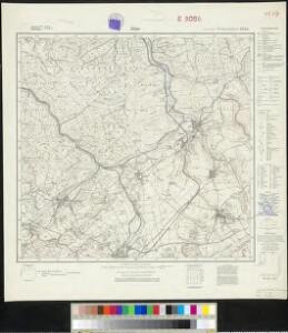
Messtischblatt 2585 : Alme, 1930 Alme
1 : 250000 Alme. - Hrsg. 1900, bericht. 1930. - 1:25000. - [Berlin]: Reichsamt für Landesaufnahme, 1930. - 1 Kt.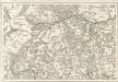
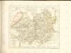
Tableau Topographique Qui comprend la Partie Septentrionale du Landgraviat de Hesse Cassel et de la Principauté de Waldeck, l'Eveché de Paderborn, Partie du Comté de Grubenhague et les Frontieres de ces Etats]
1 : 130000 Mollova mapová sbírka Julien, Roch-Joseph Julien, Roch Joseph
Waldeccensis comitatvs descriptio accvratissima
1 Karte : Kupferdruck ; 31 x 21 cm Moers; Ortelius s.n.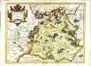
Waldeck comitatus
1 Karte : Kupferdruck ; 34 x 44 cm Hondius; Mercator Henricus Hondius
Waldeck comitatus
1 Karte : Kupferdruck ; 34 x 44 cm Mercator s.n.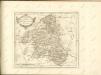

111. Arolsen, uit: Topographische Uebersichtskarte des Deutschen Reiches / herausgegeben v. d. Kartogr. Abt. d. Königl. Preuß. Landesaufnahme
1 : 200000 titelvariant: Topogr. Übersichtskarte des Deutschen Reiches; Annotatie: Titel boven bladen ook: Topogr. Übersichtskarte des Deutschen Reiches; Annotatie geografische gegevens: Op elk blad twee maatstokken: 10 Kilometer = 5,5 cm; 1 geogr. Meile = 3,6 cm; Legenda onder op elk blad Königlich Preußische Landesaufnahme. Kartographische Abtheilung [S.l : Königlich Preußische Landesaufnahme, Kartographische Abtheilung]

Waldeck Comitatvs
1 : 190000 Mollova mapová sbírka Valk, Gerhard Schenk, Peter II
Waldeck Comitatus
1 : 220000 Mollova mapová sbírka Mercator, Gerhard Mercator, Gerard
Waldecciae ac Finitimorum Dominiorum Itterani & Casteiniani nec non infertae Dioeceses Eimelrodensis accurata Tabula excusa
1 : 110000 Mollova mapová sbírka Homann, Johann Baptist Homann, Johann Baptista - dědici
Le Landgraviat de Hesse-Cassel Meridional et Septentr: avec une Partie du Landgraviat de Hesse-Darmstat et de la Vetteravie avec autres dependences
1 : 200000 Mollova mapová sbírka Carlet, Louis-François Lotter, Tobias Conrad
Waldeck Comitatus. [Karte], in: Gerardi Mercatoris et I. Hondii Newer Atlas, oder, Grosses Weltbuch, Bd. 1, S. 215.
1 Karte aus Atlas Mercator, Gerhard und Hondius, Jodocus Jansson, Jan
Landgrafiatvs Hasso-Cassellanvs typo geographico quatuor Foliorum expressus Cura Homannianorum Heredum Norimb: 1761
1 : 160000 Mollova mapová sbírka Homann, Johann Baptist Homann, Johann Baptista - dědici
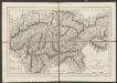
Ducatus Westphaliae Cum annexis
1 : 270000 Mollova mapová sbírka Gigas, Johann Michael Gigas, Johannes
Ducatus Westphaliae Cum annexis
1 : 270000 Mollova mapová sbírka Gigas, Johann Michael Gigas, Johannes
WALDECK | COMITATVS
Amsterdami | Apud Guiljelmum Blaeu
Waldeck Comitatus. [Karte], in: Theatrum orbis terrarum, sive, Atlas novus, Bd. 1, S. 236.
1 Karte aus Atlas Blaeu, Joan Blaeu, Willem Janszoon
Waldeck Comitatus. [Karte], in: Novus Atlas, das ist, Weltbeschreibung, Bd. 1, S. 144.
1 Karte aus Atlas Blaeu, Joan Blaeu, Willem Janszoon
Waldeck Comitatus. [Karte], in: Gerardi Mercatoris Atlas, sive, Cosmographicae meditationes de fabrica mundi et fabricati figura, S. 355.
1 Karte aus Atlas Mercator, Gerhard Montanus, Petrus
Waldeck Comitatus. [Karte], in: Novus atlas absolutissimus, Bd. 2, S. 165.
1 Karte aus Atlas Janssonius Offizin
Waldeck Comitatus. [Karte], in: Le théâtre du monde, ou, Nouvel atlas contenant les chartes et descriptions de tous les païs de la terre, Bd. 1, S. 175.
1 Karte aus Atlas Blaeu, Willem Janszoon und Blaeu, Joan Blaeu, Willem Janszoon
Delineatio Geographica generalis comprehendens VI. Foliis Singulos Principatvs Comitatvs Ditiones Dynastias omnes quotquot Imperio Serenissimi Principis Landgrafii Hasso-Darmstadiensis subsunt :
1 : 180000 Mollova mapová sbírka Bronner, Christian Maximilian Homann, Johann Baptista - dědici
PADERBORNENSIS | Episcopatus | DESCRIPTIO NOVA
Ioanne Gigante Ludense D. Med. et Math. auth. Amstelodami Judocus Hondius excudit
Episcopatvs Paderborn nec non Abbatiae Corvei Territorium seculare
1 : 190000 Mollova mapová sbírka Gigas, Johann Michael Homann, Johann Baptista - dědici
Paderbornensis Episcopatus Descriptio Nova [Karte], in: Le théâtre du monde, ou, Nouvel atlas contenant les chartes et descriptions de tous les païs de la terre, Bd. 1, S. 169.
1 Karte aus Atlas Blaeu, Willem Janszoon und Blaeu, Joan Blaeu, Willem Janszoon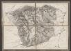
Episcopatus Paderbornensis descriptio nova [Karte], in: Gerardi Mercatoris et I. Hondii Newer Atlas, oder, Grosses Weltbuch, Bd. 1, S. 167.
1 Karte aus Atlas Mercator, Gerhard und Hondius, Jodocus Jansson, Jan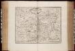
Episcopatus Paderbornensis descriptio nova / Iohanne Gigante Ludense ; [Henricus Hondius]
1 : 225000 Annotatie: Het eerst verschenen in: Novus Atlas ... Ersten Theils, Ander Stück. - Amstelodami : apud Ioannem Ianssonium, 1644; 1e staat: Amstelodami : Henricus Hondius, [1630]; Origineel is Blad 75 in atlas factice Gigas, Joannes (1580-1650); Hondius, Henricus Amstelodami : Joannes Janssonius excudit