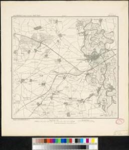
Maps of Eilenburg

Meßtischblatt 4541 : Eilenburg, 1937
1 : 250000 Eilenburg. - Aufgen. 1905, hrsg. 1907, berichtigt 1923, einz. Nachtr. 1935. - 1:25000. - Leipzig, 1937. - 1 Kt.
Meßtischblatt 3.(2609) : Eilenburg, 1930
1 : 250000 Eilenburg. - Aufgen. 1905, hrsg. 1907, berichtigt 1923, einz. Nachtr. 1930. - 1:25000. - Leipzig, 1930. - 1 Kt.
Meßtischblatt 3.(2609) : Pönitz (Sächs.) - Eilenburg (Preuß.), 1917
1 : 250000 Pönitz (Sächs.) - Eilenburg (Preuß.). - Aufgen. 1905, hrsg. 1907, einz. Nachtr. 1917. - 1:25000. - Leipzig, 1917. - 1 Kt.
Meßtischblatt 3.(2609) : Pönitz (Sächs.) - Eilenburg (Preuß.), 1912
1 : 250000 Pönitz (Sächs.) - Eilenburg (Preuß.). - Aufgen. 1905, hrsg. 1907, einz. Nachtr. 1912. - 1:25000. - Leipzig, 1912. - 1 Kt.
Messtischblatt 2609 : Eilenburg, 1874 Eilenburg
1 : 250000 Eilenburg. - Aufn. 1851. - 1:25000. - [Berlin]: Reichsamt für Landesaufnahme, 1874. - 1 Kt.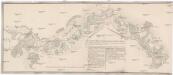
Mulda Fluss
1 : 35000 Mulda (Německo : řeka)
Plan des Schlachtfeldes um Leipzig
1 : 220000 Lipsko-oblast (Německo) Aster, Friedrich Bach, Joseph Academie der bildenden Künste
Accurate Geographische Delineation des Stiffts Ambts Wurtzen nebst dem Aembtern Eilenburg und Düben
1 : 120000 Mollova mapová sbírka Schenk, Pieter Schenk, Peter II
Praefecturae Saxonicae Wurcensis Eilenburgensis Dubensis Geographica accuratione, secundum oppida vicos pagos, vicinias descriptae
1 : 110000 Mollova mapová sbírka Seutter, Matthäus Lotter, Tobias Conrad Seutter, Matthäus
Anmarsch des Königs von Preussen aus dem Lager bei Schilda zur Schlacht bei Torgau den 3ten November 1760
1 : 133000
115. Leipzig, uit: Topographische Uebersichtskarte des Deutschen Reiches / herausgegeben v. d. Kartogr. Abt. d. Königl. Preuß. Landesaufnahme
1 : 200000 titelvariant: Topogr. Übersichtskarte des Deutschen Reiches; Annotatie: Titel boven bladen ook: Topogr. Übersichtskarte des Deutschen Reiches; Annotatie geografische gegevens: Op elk blad twee maatstokken: 10 Kilometer = 5,5 cm; 1 geogr. Meile = 3,6 cm; Legenda onder op elk blad Königlich Preußische Landesaufnahme. Kartographische Abtheilung [S.l : Königlich Preußische Landesaufnahme, Kartographische Abtheilung]
Accurate geographische delineatio des Creis Ammtes Leipzig, nebst allen dar angrentzenden Aemtern und Gegenden
1 : 121000 Lipsko-oblast (Německo) Schenk, Pieter Lotter, Tobias Conrad P. Schenk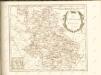

Leipzig 74, uit: Special-Karte von Mittel-Europa / nach amtlichen Quellen bearbeitet von W. Liebenow
1 : 300000 titelvariant: W. Liebenow's Mittel-Europa; Annotatie: Titel boven de bladen: W. Liebenow's Mittel-Europa Johannes Wilhelm Liebenow 1822-1897 Frankfurt a. M. : Ludwig Ravenstein
Regiae celsitvdini sereniss. principi ac domino Frieder. Christiano Leopoldo [...] consistorii Wittebergensis tabvlam hanc geographicam svmma mentis pietate consecravit
1 : 250000 Braniborsko (Německo) Vierenklee, Johann Ehrenfried Homannianos Heredes

Regiae Celsitvdini Sereniss. Principi ac Dno. Frider. Christiano Leopoldo Princ. Pol. et Lith. Reg. Princ. Elect. ac Dvci Sax. Dno. Svo Longe Clementiss. Consistorii Wittebergensis Tabvlam Hanc Geographicam Svmma Mentis Pietate Consecravit Svbiectissimvs
1 : 250000 Mollova mapová sbírka Vierenklee, Johann Ehrenfried Homann, Johann Baptista - dědici
Saxonia Svperior.
1 : 350000 Mollova mapová sbírka Janssonius van Waesberge, Johannes Pitt, Moses
Saxonia Svperior & Hall Episcopatvs
1 : 300000 Mollova mapová sbírka Blaeu, Joan Blaeu, Joan I.
SAXONIA | SVPERIOR, & | HALL EPISCOPATVS.
Amstelædami J. Blaeu excudebat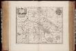
Saxonia svperior
1 : 350000 Annotatie: Origineel is Blad 98 in atlas factice; Annotatie geografische gegevens: Schaalvermelding op de kaart: 2 Milliaria Germanica communia; Rechtsboven binnen kader: XXI; De kaart toont Ober Sachsen met het bisdom Halle, het vorstendom Anhalt en het graafschap Barby Johannes Janssonius van Waesberge -1681?; Moses Pitt ca. 1654-1696; Stephanus Swart [Oxford : apud Janssonio-Waesbergios, Mosem Pitt et Stephanum Swart]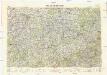
Neubertova generální automapa Republiky československé
1 : 200000 Lipsko (Německo : oblast) Soukup, Jan V. Neubert a synové
Marchionatus Lusatiae superioris felicissimo Poloniae regis, electoris Saxoniae, sceptro florens, dynastiis et praefecturis suis distributus
Horní Lužice (Německo) Lotter, Tobias Conrad T. C. Lotter
Marchionatus Lusatiae superioris felicissimo Poloniae regis, electoris Saxoniae, sceptro florens, dynastiis et praefecturis suis distributus
Horní Lužice (Německo) Lotter, Tobias Conrad Lotter, Tobias Conrad T. C. Lotter
Marchionatus Lusatiae superioris felicissimo Poloniae regis, electoris Saxoniae, sceptro florens, dynastiis et praefecturis suis distributus
Horní Lužice (Německo) Lotter, Tobias Conrad Tob. Con. Lotter
Marchionatus Lusatiae superioris felicissimo Poloniae regis, electoris Saxoniae, sceptro florens, dynastiis et praefecturis suis distributus nova accuratione
Horní Lužice (Německo) Lotter, Tobias Conrad T. C. Lotter
Saxonia Superior [Karte], in: Novus atlas absolutissimus, Bd. 2, S. 66.
1 Karte aus Atlas Janssonius Offizin
Geographische Charte des Hertzogthums und Halle Nebst etlichen angräntzende Orthen und Fürstenthume Gestochen
1 : 310000 Mollova mapová sbírka Schenk, Pieter Schenk, Peter II
Ducatus Magdeburgensis et Halensis cum finitimis Delineatio geographica curante
1 : 320000 Mollova mapová sbírka Seutter, Matthäus Lotter, Tobias Conrad Seutter, Matthäus