Maps of Oechlitz

Meßtischblatt 4636 : Schafstädt, 1941
1 : 250000 Schafstädt. - Aufn. 1903, hrsg. 1905, bericht. 1930, letzte Nachtr. 1938. - 1:25000. - [Berlin]: Reichsamt für Landesaufnahme, 1941. - 1 Kt.
Meßtischblatt 2678 : Schafstedt, 1912
1 : 250000 Schafstedt. - Aufn. 1903, hrsg. 1905, einz. Nachtr. 1912. - 1:25000. - [Berlin]: Reichsamt für Landesaufnahme, 1912. - 1 Kt.
Meßtischblatt 2678 : Schafstaedt, 1872
1 : 250000 Schafstaedt. - Aufn. 1852. - 1:25000. - [Berlin]: Reichsamt für Landesaufnahme, 1872. - 1 Kt.
Plan de la Bataille, Gagnée par Sa Majesté le Roi de Prusse, contre les Armées combinées de l'Empire & de France, près de Rosbach, le 5. Novembre, 1757
1 : 95000 Mollova mapová sbírka Schley, Jacobus van der Hondt, Pierre de
Plan de la bataille, gagnée par Sa Majesté le roi de Prusse, contre les armées combinées de l'empire & de France, prés de Rosbach, le 5. novembre 1757
Rossbach (Německo) Schley, Jacobus van der Hondt, Pierre de Pierre de Hondt
Delineatio geographica Ditionis Martisburgensis...

114. Halle, uit: Topographische Uebersichtskarte des Deutschen Reiches / herausgegeben v. d. Kartogr. Abt. d. Königl. Preuß. Landesaufnahme
1 : 200000 titelvariant: Topogr. Übersichtskarte des Deutschen Reiches; Annotatie: Titel boven bladen ook: Topogr. Übersichtskarte des Deutschen Reiches; Annotatie geografische gegevens: Op elk blad twee maatstokken: 10 Kilometer = 5,5 cm; 1 geogr. Meile = 3,6 cm; Legenda onder op elk blad Königlich Preußische Landesaufnahme. Kartographische Abtheilung [S.l : Königlich Preußische Landesaufnahme, Kartographische Abtheilung]
Mansfeldiae comitatvs descriptio
1 Karte : Kupferdruck ; 36 x 41 cm Stella; Ortelius; Hogenberg s.n.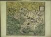
Mansfeldiae comitatvs descriptio
1 Karte : Kupferdruck ; 36 x 41 cm Stella; Ortelius; Hogenberg s.n.
Accurate Geographische Delineation der Graffschafft Mannsfelt Sowohl Char Sächsisch: als Brandenb. Hoheit
1 : 120000 Mollova mapová sbírka Mol, Pieter Schenk, Peter II
Delineatio geographica Comitatus Mansfeldensis
1 : 120000 Mollova mapová sbírka Seutter, Matthäus Seutter, Matthäus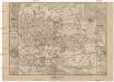
Mansfeldici comitatus typus chorographicus
1 : 180000 Halle an der Saale-oblast (Německo) Stella, Tilemann Mansfeld, Bruno a M. Iohanne Mellingero
Comitatvs Mansfeldiae Descriptio
1 : 210000 Mollova mapová sbírka Stella, Tilemann Schenk, Peter I
Comitatvs Mansfeldiae Descriptio
1 : 210000 Mollova mapová sbírka Stella, Tilemann Janssonius, Johannes I
Mansfeldiae Comitatvs descriptio auctore Tilemanno Stella Sig.
1 : 180000 Mollova mapová sbírka Stella, Tilemann Hogenberg, Franz Braun, Georg
Mansfeldia Comitatvs
1 : 170000 Mollova mapová sbírka Stella, Tilemann Blaeu, Joan I.
Mansfeldia Comitatvs
1 : 240000 Mollova mapová sbírka Merian, Matthaeus Merian, Matthäus

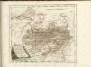
Sectio Inferior, Dvcatvs Vinariensem, nec non Isenacensis Partes Boreales et Orientales, Principatvm Qverfvrtensem, ut et Territorium Erfvrtense, Comitatvm Beichlingen, Balifiatum Thvringiae et alia repraesentans
1 : 200000 Mollova mapová sbírka Zollmann, Johann Wilhelm Oetinger, Christ. Friedrich Homann, Johann Baptista - dědici
MANSFELDIA | COMITATVS
Auctore Tilemanno Stella Sig. Apud Guiljelm. Blaeu.
Mansfeldiae Comitatus Descriptio. [Karte], in: Theatrum orbis terrarum, S. 130.
1 Karte aus Atlas Ortelius, Abraham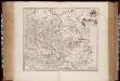
Mansfeldia comitatvs / auctore Tilemanno Stella sig
1 : 170000 Annotatie: Origineel is Blad 99 in atlas factice; Annotatie geografische gegevens: Schaalvermelding op kaart: 2 Milliaria Germanica communia; Kaart toont het graafschap Mansfeld in het gebied tussen Aschersleben, Halle an der Saale, Wiehe Unstruttal en Stolberg Tilemann Stella 1525-1589 [Amsterdami : apud Guiljelm. Blaeu]
Mansfeldiae Comitatus Descriptio. [Karte], in: Theatrum orbis terrarum, S. 222.
1 Karte aus Atlas Ortelius, Abraham Vrients, Jan Baptista
Mansfeldia Comitatus [Karte], in: Theatrum orbis terrarum, sive, Atlas novus, Bd. 1, S. 245.
1 Karte aus Atlas Blaeu, Joan Blaeu, Willem Janszoon
Comitatus Mansfeldia [Karte], in: Gerardi Mercatoris et I. Hondii Newer Atlas, oder, Grosses Weltbuch, Bd. 1, S. 289.
1 Karte aus Atlas Mercator, Gerhard und Hondius, Jodocus Jansson, Jan
Mansfeldia Comitatus [Karte], in: Novus Atlas, das ist, Weltbeschreibung, Bd. 1, S. 162.
1 Karte aus Atlas Blaeu, Joan Blaeu, Willem Janszoon
Comitatus Mansfeldiae Descriptio. [Karte], in: Novus atlas absolutissimus, Bd. 2, S. 75.
1 Karte aus Atlas Janssonius Offizin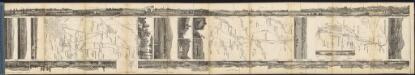
Mansfeldia Comitatus [Karte], in: Le théâtre du monde, ou, Nouvel atlas contenant les chartes et descriptions de tous les païs de la terre, Bd. 1, S. 193.
1 Karte aus Atlas Blaeu, Willem Janszoon und Blaeu, Joan Blaeu, Willem Janszoon