Maps of Eslohe

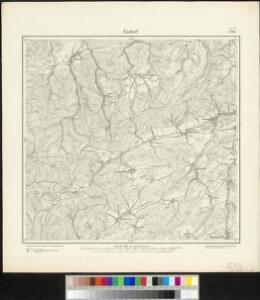
Meßtischblatt 2726 : Endorf, 1896
1 : 250000 Endorf. - Aufn. 1894. - 1:25000. - [Berlin]: Reichsamt für Landesaufnahme, 1896. - 1 Kt.
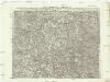
110. Arnsberg, uit: Topographische Uebersichtskarte des Deutschen Reiches / herausgegeben v. d. Kartogr. Abt. d. Königl. Preuß. Landesaufnahme
1 : 200000 titelvariant: Topogr. Übersichtskarte des Deutschen Reiches; Annotatie: Titel boven bladen ook: Topogr. Übersichtskarte des Deutschen Reiches; Annotatie geografische gegevens: Op elk blad twee maatstokken: 10 Kilometer = 5,5 cm; 1 geogr. Meile = 3,6 cm; Legenda onder op elk blad Königlich Preußische Landesaufnahme. Kartographische Abtheilung [S.l : Königlich Preußische Landesaufnahme, Kartographische Abtheilung]
Waldeck Comitatvs
1 : 190000 Mollova mapová sbírka Valk, Gerhard Schenk, Peter II
Waldeck Comitatus
1 : 220000 Mollova mapová sbírka Mercator, Gerhard Mercator, Gerard
Ducatus Westphaliae Cum annexis
1 : 270000 Mollova mapová sbírka Gigas, Johann Michael Gigas, Johannes
Ducatus Westphaliae Cum annexis
1 : 270000 Mollova mapová sbírka Gigas, Johann Michael Gigas, Johannes
Delineatio Geographica generalis comprehendens VI. Foliis Singulos Principatvs Comitatvs Ditiones Dynastias omnes quotquot Imperio Serenissimi Principis Landgrafii Hasso-Darmstadiensis subsunt :
1 : 180000 Mollova mapová sbírka Bronner, Christian Maximilian Homann, Johann Baptista - dědici

Ducatus Westphalia
1 : 227000 Vestfálsko (Německo) Seutter, Matthäus sumtibus Matthaei Seutteri
Le Comté de la Marck, Les Seigneuries des Abbayes de Werden, d'Essen, et la Ville Imperiale de Dortmundt
1 : 230000 Mollova mapová sbírka Sanson, Guillaume Ottens, Josua
Le Comté de la Marck, Les Seigneuries des Abbayes de Werden, d'Essen, et la Ville Imperiale de Dortmundt
1 : 230000 Mollova mapová sbírka Sanson, Guillaume Jaillot, Alexis Hubert
Westphalia Dvcatvs
1 : 270000 Mollova mapová sbírka Valk, Gerhard Schenk, Peter I
Westphalia Dvcatvs
1 : 270000 Mollova mapová sbírka Janssonius, Johannes Janssonius, Johannes I

WESTPHALIA | Ducatus
[Amsterdam : Joan Blaeu]
Carte du Comté de la Marck
1 : 160000 Mollova mapová sbírka Le Rouge, Georges-Louis Le Rouge, Georges-Louis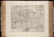
Westfalia ducatus / [Joannes Janssonius]
1 : 290000 Annotatie: Rechtsboven: XXIX; Verschenen in: The English atlas volume III ... - Amsterdam : J. Jansonius a Waesberg and S. Swart, 1683; Origineel is Blad 74 in atlas factice; Oorspr. uitg.: Amstelodami : excudebat Ioannes Ianssonius, [1630] Janssonius, Joannes (jr.) (1588-1664) [Amsterdam : J. Jansonius van Waesberge etc.]
Westphalia ducatus
1 : 276000 Vestfálsko (Německo) Gigas, Johann Michael Blaeu, Willem Janszoon Guiljelmus Blaeuw excudit
COMITATVS | MARCHIA | ET | RAVENSBERG
[Amsterdam : Joan Blaeu]
Le Comté De La Marck, Les Seigneuries Des Abbayes De Werden, D'Essen, Et La Ville Imperiale De Dortmundt. [Karte], in: Atlas nouveau, contenant toutes les parties du monde [...], Bd. 1, S. 226.
1 Karte aus Atlas Sanson, Nicolas Jaillot, Alexis Hubert und Mortier, Pieter
Nova Ducatus Westphaliae Tabula Accurate descripta et in Satrapias et Dynastias distincte divisa
1 : 220000 Mollova mapová sbírka Ottens, Reinier Ottens, Josua
Le Duché de Westphalie
1 : 250000 Mollova mapová sbírka Sanson, Guillaume Covens, Johannes I
Le Duché de Westphalie
1 : 250000 Mollova mapová sbírka Sanson, Guillaume Jaillot, Alexis Hubert
Le Duché de Westphalie
1 : 250000 Mollova mapová sbírka Sanson, Guillaume Jaillot, Alexis Hubert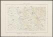
Westphalia Ducatus [Karte], in: Theatrum orbis terrarum, sive, Atlas novus, Bd. 1, S. 215.
1 Karte aus Atlas Blaeu, Joan Blaeu, Willem Janszoon
Westphalia Ducatus [Karte], in: Novus Atlas, das ist, Weltbeschreibung, Bd. 1, S. 141.
1 Karte aus Atlas Blaeu, Joan Blaeu, Willem Janszoon
Westphalia Ducatus [Karte], in: Novus atlas absolutissimus, Bd. 2, S. 127.
1 Karte aus Atlas Janssonius Offizin
Westphalia Ducatus [Karte], in: Le théâtre du monde, ou, Nouvel atlas contenant les chartes et descriptions de tous les païs de la terre, Bd. 1, S. 172.
1 Karte aus Atlas Blaeu, Willem Janszoon und Blaeu, Joan Blaeu, Willem Janszoon
Westphalia Ducatus [Karte], in: Gerardi Mercatoris et I. Hondii Newer Atlas, oder, Grosses Weltbuch, Bd. 1, S. 191.
1 Karte aus Atlas Mercator, Gerhard und Hondius, Jodocus Jansson, Jan