Maps of Berkatal

Meßtischblatt 2737, neue Nr. 4725 : Bad Sooden- Allendorf, 1936
1 : 250000 Bad Sooden - Allendorf. - Hrsg. 1909, einz. Nachtr. 1936. - 1:25000. - [Berlin]: Reichsamt für Landesaufnahme, 1936. - 1 Kt.
Meßtischblatt 2737 : Allendorf- Sooden, 1913
1 : 250000 Allendorf- Sooden. - [Hrsg. 1909, gedr. 19]13. - 1:25000. - [Berlin]: Reichsamt für Landesaufnahme, 1913. - 1 Kt.
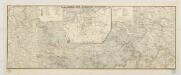
Les Environs de Cassel en Hesse et le Plan de la Battaille entre Sandershausen et Lutternberg le 10. Octobre 1758
Mollova mapová sbírka Back, Jakob Conrad
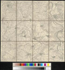
Composite: 75. Friedland a. d. Alle. (Germany)
1 : 100000 Reichsamt fur Landesaufnahme
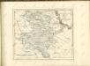
Landgraviatus Hassiae Inferioris Comitatvs Waldeciae Eichsfeldiae Tabvla Geographica
1 : 140000 Mollova mapová sbírka Berger, Daniel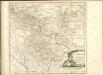
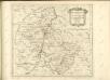

Le Landgraviat de Hesse-Cassel Meridional et Septentr: avec une Partie du Landgraviat de Hesse-Darmstat et de la Vetteravie avec autres dependences
1 : 200000 Mollova mapová sbírka Carlet, Louis-François Lotter, Tobias Conrad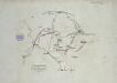
Verproviantirung von Göttingen im Januar 1761
Landgrafiatvs Hasso-Cassellanvs typo geographico quatuor Foliorum expressus Cura Homannianorum Heredum Norimb: 1761
1 : 160000 Mollova mapová sbírka Homann, Johann Baptist Homann, Johann Baptista - dědici
Landt Tafel des Eyßfeldts
1 : 180000 Mollova mapová sbírka Fluck, Johann Merian, Matthäus
Tractvs Eichsfeldiae in suas Praefecturas divisae nec non Territorii Mvlhvsani Chorographia
1 : 160000 Mollova mapová sbírka Homann, Johann Baptist Homann, Johann Baptista - dědici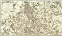
Carte Demi-Topo-Graphique De La Partie Septentrionale du Landgraviat de Hesse-Cassel
1 : 190000 Mollova mapová sbírka Carlet, Louis-François Beaurain, Jean de
112. Cassel, uit: Topographische Uebersichtskarte des Deutschen Reiches / herausgegeben v. d. Kartogr. Abt. d. Königl. Preuß. Landesaufnahme
1 : 200000 titelvariant: Topogr. Übersichtskarte des Deutschen Reiches; Annotatie: Titel boven bladen ook: Topogr. Übersichtskarte des Deutschen Reiches; Annotatie geografische gegevens: Op elk blad twee maatstokken: 10 Kilometer = 5,5 cm; 1 geogr. Meile = 3,6 cm; Legenda onder op elk blad Königlich Preußische Landesaufnahme. Kartographische Abtheilung [S.l : Königlich Preußische Landesaufnahme, Kartographische Abtheilung]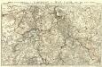
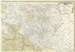
Partie Septentrionale du Landgraviat de Hesse-Cassel avec les Pays Voisins
1 : 130000 Mollova mapová sbírka Carlet, Louis-François Back, Jakob Conrad Broenner, Heinrich Ludwig II.
Cassel
1 : 300000 R. Mittelbach
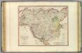
Eveché de Paderborn
1 : 230000 Mollova mapová sbírka Le Rouge, Georges-Louis Baisiez Le Rouge, Georges-Louis
Recens et Accurata Designatio Episcopatus Paderbornensis in suas Dioecenses et Praefect. Exacte Distincti
1 : 230000 Mollova mapová sbírka Seutter, Matthäus Seutter, Matthäus
Special Charte von dem Harz-Gebirge und den umliegenden Ländern
Harz-oblast (Německo) von dem Geographischen Institute
Le Theatre de Bellone :
Mollova mapová sbírka Schenk, Pieter Braakman, Adriaan
Herzogtum Sachsen-Coburg und Gotha 1830 Verwaltungsstruktur
Sachsen-Coburg-Gotha Verwaltung Kunz, Andreas ; Moeschl, Joachim Robert
Herzogtum Sachsen-Coburg und Gotha 1826 Verwaltungsstruktur
Sachsen-Coburg-Gotha Verwaltung Kunz, Andreas ; Moeschl, Joachim Robert
Herzogtum Sachsen-Coburg und Gotha 1834 Verwaltungsstruktur
Sachsen-Coburg-Gotha Verwaltung Kunz, Andreas ; Moeschl, Joachim Robert
Hassia Landgraviatus
1 : 350000 Mollova mapová sbírka Hondius, Henricus Janssonius, Johannes I
Holstein.
1 : 270000 Faden, William, 1750?-1836
Turingiae Noviss. Descript. [Karte], in: Theatrum orbis terrarum, S. 137.
1 Karte aus Atlas Ortelius, Abraham