Maps of Prawików

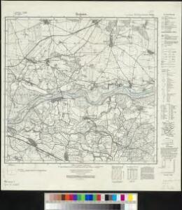
Meßtischblatt 4765 : Regnitz, 1943
1 : 250000 Regnitz. - Aufn. 1887, hrsg. 1889, bericht. 1940. - 1:25000. - [Berlin]: Reichsamt für Landesaufnahme, 1943. - 1 Kt.
Meßtischblatt 2764 : Regnitz, 1937
1 : 250000 Regnitz. - Hrsg. 1889, bericht. 1927, einz. Nachtr. 1937. - 1:25000. - [Berlin]: Reichsamt für Landesaufnahme, 1937. - 1 Kt.
Plan der Bataille von Leuthen ohnweit Lissa in Schlesien zwischen der Kayserl. Königl. und Königl. Preusischen Armee den 5. Dec. 1757 vorgefallen
1 : 50000 Back, Jakob Conrad; Brönner, Heinrich Ludwig zu finden bey H. L. Brönner auf dem Pfareyssen

Wege - Karte der Gegend um Breslau

119. Breslau, uit: Topographische Uebersichtskarte des Deutschen Reiches / herausgegeben v. d. Kartogr. Abt. d. Königl. Preuß. Landesaufnahme
1 : 200000 titelvariant: Topogr. Übersichtskarte des Deutschen Reiches; Annotatie: Titel boven bladen ook: Topogr. Übersichtskarte des Deutschen Reiches; Annotatie geografische gegevens: Op elk blad twee maatstokken: 10 Kilometer = 5,5 cm; 1 geogr. Meile = 3,6 cm; Legenda onder op elk blad Königlich Preußische Landesaufnahme. Kartographische Abtheilung [S.l : Königlich Preußische Landesaufnahme, Kartographische Abtheilung]
Ducatus | SILESIÆ | WOLANVS
Authore Jona Sculteto | Sprotta Silesio. Amstelædami | J. Blaeu excudebat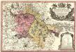
Principtus Silesiae Wratislaviensis exactissima Tabula Geographica sistens simul Circulum Neoforensem et Districtum Cantiensem, ac status minores vulgo Burglehn dictos Lissa, Kraicka, Weigwitz, Rommenau, Krolkwitz, Bogenau, Malckwitz, Auras, Gr. Peterwitz et Halt Grosburg
1 : 120000 Mollova mapová sbírka Wieland, Johann Wolfgang Homann, Johann Christoph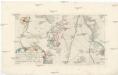
Plan der Bataille zwischen Lissa und Neumarck ohnweit Breslau, da die königl. preuss. Armee die kayserl. königl. Armee den 5 Dec. 1757. angegriffen, und nach einem scharfen Gefechte aus dem Felde geschlagen
Vratislav-oblast (Polsko)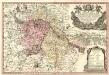
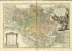
Principatus Silesiae Wratislaviensis :
1 : 120000 Mollova mapová sbírka Wieland, Johann Wolfgang Homann, Johann Baptista - dědici
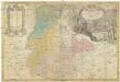
Ducatus Breslanus sive Wratislaviensis
1 : 240000 Mollova mapová sbírka Aveele, Johannes van den Schenk, Peter I
Dvcatvs Breslanvs sive Wratislaviensis
1 : 220000 Mollova mapová sbírka Vechner, Georg Blaeu, Joan I.
DVCATVS | SILESIÆ | LIGNICIENSIS
Auctore | Iona Sculteto Sprotta Silesio Amstelædami J. Blaeu excud.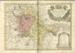

Ducatus Silesiae Ligniciensis. [Karte], in: Novus atlas absolutissimus, Bd. 2, S. 267.
1 Karte aus Atlas Janssonius Offizin
Generální mapa ČSR

Ducatus Silesiae Wolanus [Karte], in: Novus atlas absolutissimus, Bd. 2, S. 261.
1 Karte aus Atlas Janssonius Offizin
Ducatuum Silesiae Svidnicensis et Iavraviensis Delineatio :
1 : 208000 Mollova mapová sbírka Köhler, Gottfried Posch, C.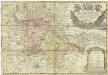
Principatus Silesiae Wratislaviensis
1 : 129000 Vratislav-oblast (Polsko) Wieland, Johann Wolfgang Schubarth, Matthäus Haeredibus Homannianis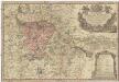
Principatus Silesiae Wratislaviensis
1 : 130000 Vratislav-oblast (Polsko) Wieland, Johann Wolfgang Schubarth, Matthäus ab Haeredibus Homannianis
DVCATVS | BRESLANVS | sive | WRATISLAVIENSIS
Amstelædami, Apud Joan. Blaeu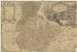
Principatvs Silesiae Iavoricensis in 4 circulos, Iaver, Hirschberg, Lemberg und Bvntzlav divisi
1 : 150000 Bolesławiec (Polsko) Wieland, Johann Wolfgang Schubarth, Matthäus Homannianos Heredes
Liegnitz 76, uit: Special-Karte von Mittel-Europa / nach amtlichen Quellen bearbeitet von W. Liebenow
1 : 300000 titelvariant: W. Liebenow's Mittel-Europa; Annotatie: Titel boven de bladen: W. Liebenow's Mittel-Europa Johannes Wilhelm Liebenow 1822-1897 Frankfurt a. M. : Ludwig Ravenstein
PRINCIP. SILESIAE IAVORIENSIS in IV. CIRCULOS, IAVER, HIRSCHBERG, LEMBERG und BVNTZLAV DIVISI
1 : 150000 Jelení Hora-oblast (Polsko) Wieland, Johann Wolfgang Schubarth, Matthaeus ab Hered. Homannianis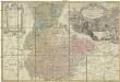
Princip. Silesiae Iavoriensis in IV. circulos, Iaver, Hirschberg, Lemberg und Bvntzlau divisi ac a I. W. Wieland
1 : 150000 Jawor (Polsko) Schubart, Mathaeum Hered. Homannianis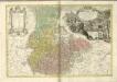

Ducatus Breslanus sive Wratislaviensis. [Karte] Breslaw totius Silesiae Metropolis. [Nebenkarte], in: Novus atlas absolutissimus, Bd. 2, S. 264.
1 Karte aus Atlas Janssonius Offizin