Maps of Juszczyn

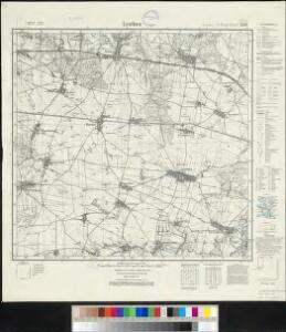
Meßtischblatt 2826 : Leuthen, 1938
1 : 250000 Leuthen. - Hrsg. 1889, bericht. 1927, einz. Nachtr. 1932, redakt. Änd. [19]38. - 1:25000. - [Berlin]: Reichsamt für Landesaufnahme, 1938. - 1 Kt.
Meßtischblatt 2826 : Leuthen, 1889
1 : 250000 Leuthen. - Aufn. 1887. - 1:25000. - [Berlin]: Reichsamt für Landesaufnahme, 1889. - 1 Kt.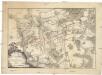
Bataille de Leuthen, en Silesie, gagnée par le roi de Prusse sur l'armée impériale, aux ordres du prince Charles de Lorraine, le 5. decembre 1757
1 : 50000 Lutynia (Polsko)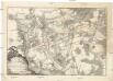
Schlacht bey Leuthen, in Schlesien, welche den 5.ten December 1757. von dem Koenig von Preussen, wieder die kayserliche Armée, unter Anführung des Printzen Carl von Lothringen gewonnen worden
1 : 50000 Lutynia (Polsko)
Plan de la bataille pres de Leuthen en Silesie le 5. decembre 1757
Lutynia (Polsko) Beaulieu Trattner, Johann Thomas Jean Thomas Trattner
Plan der Bataille von Leuthen ohnweit Lissa in Schlesien zwischen der Kayserl. Königl. und Königl. Preusischen Armee den 5. Dec. 1757 vorgefallen
1 : 50000 Back, Jakob Conrad; Brönner, Heinrich Ludwig zu finden bey H. L. Brönner auf dem Pfareyssen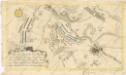
Plan der Bataille bey Breslau...

Plan de la bataille, gagnée par Sa Majesté le roi de Prusse, sur l'armée autrichienne, aux ordres de S. A. R. le duc Charles de Lorraine, prés de Leuthen, ou Lissa, en Silesie, le 5 decembre 1757
Lutynia (Polsko) Schley, Jacobus van der Hondt, Pierre de Pierre de Hondt
Grundriß der schlesischen Hauptstadt Bresslau
1 : 142000 Vratislav-oblast (Polsko) Trattner, Johann Thomas Johann Thomas Trattner
151 Breslau, uit: Topographische Special-Karte von Deutschland (von Central-Europa) / begründet von D.G. Reymann ; [entworfen und gezeichn. von Heinrich Berghaus... [et al.]]
1 : 200000 Annotatie: Lit.: Daniel Gottlob Reymann und die "Topographische Special-Karte von Deutschland" / von Wolfgang Scharfe, in: Kartographische Nachrichten, 39 (1989), Heft I, p. 1-10; Handgeschreven titel: Reymann's Deutschland : 24 Sectionen: Jena, Penig, Dresden, Zittau, Hirschberg, Breslau, Brieg, Andernach, Coblenz, Giessen, Fulda, Schleusingen, Plauen, Zwickau, Teplitz, Jung Bunzlau, Hohenelbe, Glatz, Neisse, Simmern, Prag, Luxemburg, Birkenfeld; Aanwezig: 23 bladen Reymann, Daniel Gottlob; Berghaus, Heinrich [Berlin : 2. Departement des Kriegsministeriums, Bureau für Plan- und Kartenzeichnung]
Wege - Karte der Gegend um Breslau

119. Breslau, uit: Topographische Uebersichtskarte des Deutschen Reiches / herausgegeben v. d. Kartogr. Abt. d. Königl. Preuß. Landesaufnahme
1 : 200000 titelvariant: Topogr. Übersichtskarte des Deutschen Reiches; Annotatie: Titel boven bladen ook: Topogr. Übersichtskarte des Deutschen Reiches; Annotatie geografische gegevens: Op elk blad twee maatstokken: 10 Kilometer = 5,5 cm; 1 geogr. Meile = 3,6 cm; Legenda onder op elk blad Königlich Preußische Landesaufnahme. Kartographische Abtheilung [S.l : Königlich Preußische Landesaufnahme, Kartographische Abtheilung]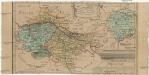
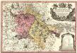
Das Fürstenthum Bresslau in Nieder-Schlesien
1 : 720000 Vratislav-oblast (Polsko) Schleuen, Johann David Schleuen
Das Fürstenthum Bresslau in Nieder-Schlesien
1 : 458300 Mollova mapová sbírka Schleuen, Johann David
Principtus Silesiae Wratislaviensis exactissima Tabula Geographica sistens simul Circulum Neoforensem et Districtum Cantiensem, ac status minores vulgo Burglehn dictos Lissa, Kraicka, Weigwitz, Rommenau, Krolkwitz, Bogenau, Malckwitz, Auras, Gr. Peterwitz et Halt Grosburg
1 : 120000 Mollova mapová sbírka Wieland, Johann Wolfgang Homann, Johann Christoph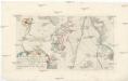
Plan der Bataille zwischen Lissa und Neumarck ohnweit Breslau, da die königl. preuss. Armee die kayserl. königl. Armee den 5 Dec. 1757. angegriffen, und nach einem scharfen Gefechte aus dem Felde geschlagen
Vratislav-oblast (Polsko)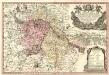
Principatus Silesiae Wratislaviensis :
1 : 120000 Mollova mapová sbírka Wieland, Johann Wolfgang Homann, Johann Baptista - dědici
Ducatus Breslanus sive Wratislaviensis
1 : 240000 Mollova mapová sbírka Aveele, Johannes van den Schenk, Peter I
Dvcatvs Breslanvs sive Wratislaviensis
1 : 220000 Mollova mapová sbírka Vechner, Georg Blaeu, Joan I.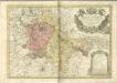

Generální mapa ČSR

Ducatus Silesiae Wolanus [Karte], in: Novus atlas absolutissimus, Bd. 2, S. 261.
1 Karte aus Atlas Janssonius Offizin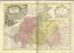

Ducatuum Silesiae Svidnicensis et Iavraviensis Delineatio :
1 : 208000 Mollova mapová sbírka Köhler, Gottfried Posch, C.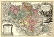
Principatvs Silesiae Oelsnensis :
1 : 154000 Mollova mapová sbírka Wieland, Johann Wolfgang Homann, Johann Baptista - dědici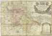
Principatus Silesiae Wratislaviensis
1 : 129000 Vratislav-oblast (Polsko) Wieland, Johann Wolfgang Schubarth, Matthäus Haeredibus Homannianis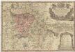
Principatus Silesiae Wratislaviensis
1 : 130000 Vratislav-oblast (Polsko) Wieland, Johann Wolfgang Schubarth, Matthäus ab Haeredibus Homannianis
DVCATVS | BRESLANVS | sive | WRATISLAVIENSIS
Amstelædami, Apud Joan. Blaeu