Maps of gmina Sulików

Meßtischblatt 4956 : Seidenberg, 1939
1 : 250000 Seidenberg. - Aufgen. sächs. Teil 1902, preuß. Teil 1886, hrsg. sächs. Teil 1906, preuß. Teil 1888, bericht. 1930, einz, Nachtr. 1936, Umdruckausg.. - 1:25000. - Leipzig, 1939. - 1 Kt.
Meßtischblatt 74 (2880) : Seidenberg, 1934
1 : 250000 Seidenberg. - Umdr.-Ausg., aufgen. sächs. Teil 1902, preuß. Te. - 1:25000. - Leipzig, 1934. - 1 Kt.
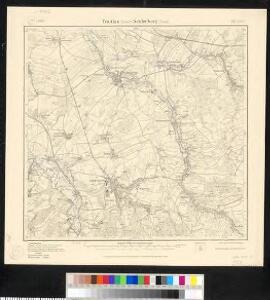
Meßtischblatt 74.(2880) : Trattlau (Sächs.) - Seidenberg (Preuß.), 1922
1 : 250000 Trattlau (Sächs.) - Seidenberg (Preuß.). - Aufgen. 1902, hrsg. 1915, einz. Nachtr. 1922. - 1:25000. - Leipzig, 1922. - 1 Kt.
Meßtischblatt 74.(2880) : Trattlau (Sächs.) - Seidenberg (Preuß.), 1915
1 : 250000 Trattlau (Sächs.) - Seidenberg (Preuß.). - Aufgen. 1902. - 1:25000. - Leipzig, 1915. - 1 Kt.
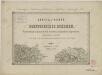
Plan de la Position du corps de S. [...] monsigneur le Prince de Durlach
1 : 30000 Sulików (Polsko)
III. vojenské mapování 3554/3
1 : 25000
III. vojenské mapování 3554/3
1 : 25000
III. vojenské mapování 3554/3
1 : 25000
[Gradkartenblatt]
1 : 25000 Čechy (Česko) Vojenský zeměpisný ústav
III. vojenské mapování 3554/4
1 : 25000
III. vojenské mapování 3554/4
1 : 25000
[Gradkartenblatt]
1 : 25000 Habartice (Liberec, Česko) Vojenský zeměpisný ústav
Wiese - c8494-1-001 - Kaiserpflichtexemplar der Landkarten des stabilen Katasters
1 : 2880
Wiese - c8494-1-002 - Kaiserpflichtexemplar der Landkarten des stabilen Katasters
1 : 2880
Ebersdorf - c1729-1-002 - Kaiserpflichtexemplar der Landkarten des stabilen Katasters
1 : 2880
Ebersdorf - c1729-1-001 - Kaiserpflichtexemplar der Landkarten des stabilen Katasters
1 : 2880
Göhe - c1747-1-002 - Kaiserpflichtexemplar der Landkarten des stabilen Katasters
1 : 2880
Göhe - c1747-1-001 - Kaiserpflichtexemplar der Landkarten des stabilen Katasters
1 : 2880
Bunzendorf - c0345-2-001 - Kaiserpflichtexemplar der Landkarten des stabilen Katasters
1 : 2880
Bunzendorf - c0345-2-002 - Kaiserpflichtexemplar der Landkarten des stabilen Katasters
1 : 2880
III. vojenské mapování 3554/4
1 : 25000
[Kartenblatt]
1 : 25000 Dolní Oldřiš (Bulovka, Liberec, Česko) Reichsamt für Landesaufnahme
Tschernhausen - c0907-1-002 - Kaiserpflichtexemplar der Landkarten des stabilen Katasters
1 : 2880
Tschernhausen - c0907-1-003 - Kaiserpflichtexemplar der Landkarten des stabilen Katasters
1 : 2880
Tschernhausen - c0907-1-001 - Kaiserpflichtexemplar der Landkarten des stabilen Katasters
1 : 2880
Nieder Ullersdorf - c1353-1-002 - Kaiserpflichtexemplar der Landkarten des stabilen Katasters
1 : 2880
Nieder Ullersdorf - c1353-1-004 - Kaiserpflichtexemplar der Landkarten des stabilen Katasters
1 : 2880
Nieder Ullersdorf - c1353-1-003 - Kaiserpflichtexemplar der Landkarten des stabilen Katasters
1 : 2880
Nieder Ullersdorf - c1353-1-001 - Kaiserpflichtexemplar der Landkarten des stabilen Katasters
1 : 2880