Maps of gmina Platerówka

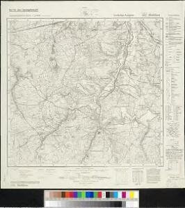
Meßtischblatt 4957 : Marklissa, 1940
1 : 250000 Marklissa. - Aufn. 1886, hrsg. 1888, bericht. 1937. - 1:25000. - [Berlin]: Reichsamt für Landesaufnahme, 1940. - 1 Kt.
Meßtischblatt 2881 : Marklissa, 1888
1 : 250000 Marklissa. - Aufn. 1886. - 1:25000. - [Berlin]: Königl. Preuss. Landesaufnahme, 1888. - 1 Kt.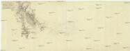
Lager der k. k. Armée, im Jahr 1759 im Fruh-Jahr, bey Marcklissa in Schleßien anaus gearbeitet. Da der König aus Preußen das Lager bey [Schmotseihfen] besetzte
Leśna-oblast (Polsko)
[Kartenblatt]
1 : 25000 Dolní Oldřiš (Bulovka, Liberec, Česko) Reichsamt für Landesaufnahme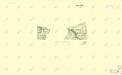
III. vojenské mapování 3554/4
1 : 25000
Tschernhausen und Preuss. Cörlitz [sic]
1 : 75000 Görlitz-oblast (Německo) K. u. k. Militärgeographisches Institut
III. vojenské mapování 3554
1 : 75000

Podrobná mapa Království českého
1 : 100000 Frýdlant (Česko : oblast) Srp, Jan Jos. R. Vilímek
Karte der Bezirkshauptmannschaft Friedland
1 : 100000 Frýdlant-oblast (Česko) Erben, Josef Karl Janský
Bezirk Friedland

III. vojenské mapování 3654/2, 3554/4
1 : 25000
III. vojenské mapování 3654/2, 3554/4
1 : 25000
III. vojenské mapování 3654/2, 3554/4
1 : 25000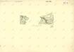
III. vojenské mapování 3554/4
1 : 25000
Nieder Ullersdorf - c1353-1-002 - Kaiserpflichtexemplar der Landkarten des stabilen Katasters
1 : 2880
Nieder Ullersdorf - c1353-1-004 - Kaiserpflichtexemplar der Landkarten des stabilen Katasters
1 : 2880
Nieder Ullersdorf - c1353-1-003 - Kaiserpflichtexemplar der Landkarten des stabilen Katasters
1 : 2880
Nieder Ullersdorf - c1353-1-001 - Kaiserpflichtexemplar der Landkarten des stabilen Katasters
1 : 2880
III. vojenské mapování 3554/4
1 : 25000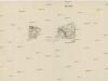
[Gradkartenblatt]
1 : 25000 Čechy (Česko) Vojenský zeměpisný ústav
Tschernhausen und Preuss. Corlitz.
from Spezialkarte der osterreichisch-ungarischen Monarchie.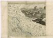
Müllerova mapa Čech
1 : 132000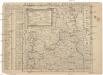
Mappa vicariatus Fridlandensis
Frýdlant-oblast (Česko) Kreibich, František Jakub Jindřich
117. Görlitz, uit: Topographische Uebersichtskarte des Deutschen Reiches / herausgegeben v. d. Kartogr. Abt. d. Königl. Preuß. Landesaufnahme
1 : 200000 titelvariant: Topogr. Übersichtskarte des Deutschen Reiches; Annotatie: Titel boven bladen ook: Topogr. Übersichtskarte des Deutschen Reiches; Annotatie geografische gegevens: Op elk blad twee maatstokken: 10 Kilometer = 5,5 cm; 1 geogr. Meile = 3,6 cm; Legenda onder op elk blad Königlich Preußische Landesaufnahme. Kartographische Abtheilung [S.l : Königlich Preußische Landesaufnahme, Kartographische Abtheilung]
Wegekarte vom Riesen- und Iser-Gebirge
1 : 150000 Jizerské hory-oblast (Česko a Polsko) Straube, Julius Geograph. Inst. u. Landkarten-Verlag v. Jul. Straube
Geographische Verzeichnung des GOERLIZER CREISES mit dem QVEISS-CREISE welches zusammen ist der Ostliche Theil von dem Marggrafthum OBER LAVSITZ
1 : 180000 Görlitz (Německo) vom Homaennischen Erben
Geographische Verzeichnung des Goerlizer Creises mit dem Qveiss-Creise
1 : 176200 Görlitz (Německo) Homaennischen Erben
Geographische Verzeichnung des Goerlizer Creises mit dem Qveiss-Creise welches zusammen ist der Ostliche Theil von dem Marggrafthum Ober Lavsiz
1 : 180000 Mollova mapová sbírka Homann, Johann Baptist Homann, Johann Baptista - dědici