Maps of Oderwitz

Meßtischblatt 5054 : Zittau (Nord), 1942
1 : 250000 Zittau (Nord). - Aufn. 1928, hrsg. 1931, letzte Nachtr. 1937, Aus. - 1:25000. - Leipzig, 1942. - 1 Kt.
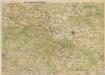
Meßtischblatt 88 : Zittau (Nord), 1934
1 : 250000 Zittau (Nord). - Umdr.-Ausg., aufgen. 1928, hrsg. 1931, einz. Nachtr. 1934. - 1:25000. - Leipzig, 1934. - 1 Kt.
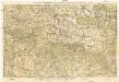
Meßtischblatt 88 : Zittau (Nord), 1931
1 : 250000 Zittau (Nord). - Aufgen. 1928. - 1:25000. - Leipzig, 1931. - 1 Kt.
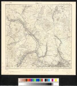
Meßtischblatt 88 : Oderwitz, 1913
1 : 250000 Oderwitz. - Aufgen. 1899, rev. 1906, hrsg. 1908, kurrentgest. 1913. - 1:25000. - Leipzig, 1913. - 1 Kt.
[Kartenblatt]
1 : 25000 Varnsdorf (Česko : oblast) Reichsamt für Landesaufnahme

Plan von Zittau
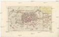
Grund-Riss der ruinirten Stadt Zittau
Žitava (Německo) in der Raspischen Buchhandlung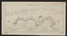
Karte der Löbau-Zittauer Eisenbahn
1 : 57000 Lith. v. F.A. Renner
III. vojenské mapování 3653
1 : 75000
Varnsdorf
1 : 75000 Varnsdorf-oblast (Česko) Vojenský zeměpisný ústav
Section Zittau

Soubor přehledných map pro plánování a statistiku: Šluknov 3553

Soubor přehledných map pro plánování a statistiku: 3553 – Šluknov

Varnsdorf
1 : 75000 Cvikov (Česko : oblast) Vojenský zeměpisný ústav
Rumburg und Warnsdorf
1 : 75000 Rumburk (Česko : oblast) Lampe K. u. k. militär-geographisches Institut
Rumburg und Warnsdorf
1 : 75000 Rumburk (Česko : oblast) Lampe K. u. k. Militärgeographisches Institut
Rumburg und Warnsdorf
1 : 75000 Rumburk (Česko : oblast) K. u. k. Militärgeographisches Institut

III. vojenské mapování 3653/2
1 : 25000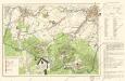
Wanderkarte Zittauer Gebirge

Die Statt Zittaw in Ober Lausitz, wie sie A°. 1632 vom Obr. Bolzen fortificirt worden, sampt der Belägerung A°. 1643
Žitava (Německo) Pezold, Daniel Mentzel, J. G.
Rumburg und Warnsdorf.
from Spezialkarte der osterreichisch-ungarischen Monarchie.
Generalkarte der Bezirkshauptmannschaft Rumburg
1 : 220000 Rumburk-oblast (Česko) Wagner, Jan Eduard F. Kytka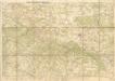
Wanderkarte durch Nordböhmen
Das nördlichste Böhmen
Neue Karte von Nordböhmen, der Oberlausitz und der Sächsischen Schweiz
1 : 75000 Horní Lužice (Německo) Heinrich Pfeifer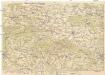
Das nördlichste Böhmen
1 : 75000 Čechy severní (Česko) Richter, A. Oesfeld, C. W.
Spezial-Karte der Sächsischen u Böhmischen Schweiz so wie der Umgegend von Dresden und dem Plauenschen Grunde
České Švýcarsko (Česko) Schmidt, Eduard Fort, L. L. Fort