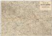
Maps of gmina Żórawina

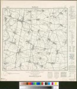
Meßtischblatt 5068 : Rothbach, 1941
1 : 250000 Rothbach. - Aufn. 1883, hrsg. 1885, bericht. 1930, letzte Nachtr. 1938. - 1:25000. - [Berlin]: Reichsamt für Landesaufnahme, 1941. - 1 Kt.
Meßtischblatt 2955 : Rothbach, 1937
1 : 250000 Rothbach. - Hrsg. 1885, bericht. 1930, einz. Nachtr. 1932, gedr. [19]37. - 1:25000. - [Berlin]: Reichsamt für Landesaufnahme, 1937. - 1 Kt.
[Manoeuvre bey Ohlau]

Grundriß der schlesischen Hauptstadt Bresslau
1 : 142000 Vratislav-oblast (Polsko) Trattner, Johann Thomas Johann Thomas Trattner
151 Breslau, uit: Topographische Special-Karte von Deutschland (von Central-Europa) / begründet von D.G. Reymann ; [entworfen und gezeichn. von Heinrich Berghaus... [et al.]]
1 : 200000 Annotatie: Lit.: Daniel Gottlob Reymann und die "Topographische Special-Karte von Deutschland" / von Wolfgang Scharfe, in: Kartographische Nachrichten, 39 (1989), Heft I, p. 1-10; Handgeschreven titel: Reymann's Deutschland : 24 Sectionen: Jena, Penig, Dresden, Zittau, Hirschberg, Breslau, Brieg, Andernach, Coblenz, Giessen, Fulda, Schleusingen, Plauen, Zwickau, Teplitz, Jung Bunzlau, Hohenelbe, Glatz, Neisse, Simmern, Prag, Luxemburg, Birkenfeld; Aanwezig: 23 bladen Reymann, Daniel Gottlob; Berghaus, Heinrich [Berlin : 2. Departement des Kriegsministeriums, Bureau für Plan- und Kartenzeichnung]
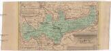
Wege - Karte der Gegend um Breslau

133. Schweidnitz, uit: Topographische Uebersichtskarte des Deutschen Reiches / herausgegeben v. d. Kartogr. Abt. d. Königl. Preuß. Landesaufnahme
1 : 200000 titelvariant: Topogr. Übersichtskarte des Deutschen Reiches; Annotatie: Titel boven bladen ook: Topogr. Übersichtskarte des Deutschen Reiches; Annotatie geografische gegevens: Op elk blad twee maatstokken: 10 Kilometer = 5,5 cm; 1 geogr. Meile = 3,6 cm; Legenda onder op elk blad Königlich Preußische Landesaufnahme. Kartographische Abtheilung [S.l : Königlich Preußische Landesaufnahme, Kartographische Abtheilung]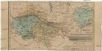
Das Fürstenthum Bresslau in Nieder-Schlesien
1 : 720000 Vratislav-oblast (Polsko) Schleuen, Johann David Schleuen
Das Fürstenthum Bresslau in Nieder-Schlesien
1 : 458300 Mollova mapová sbírka Schleuen, Johann David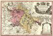
Principtus Silesiae Wratislaviensis exactissima Tabula Geographica sistens simul Circulum Neoforensem et Districtum Cantiensem, ac status minores vulgo Burglehn dictos Lissa, Kraicka, Weigwitz, Rommenau, Krolkwitz, Bogenau, Malckwitz, Auras, Gr. Peterwitz et Halt Grosburg
1 : 120000 Mollova mapová sbírka Wieland, Johann Wolfgang Homann, Johann Christoph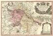
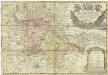
Principatus Silesiae Wratislaviensis :
1 : 120000 Mollova mapová sbírka Wieland, Johann Wolfgang Homann, Johann Baptista - dědici
Ducatus Breslanus sive Wratislaviensis
1 : 240000 Mollova mapová sbírka Aveele, Johannes van den Schenk, Peter I
Dvcatvs Breslanvs sive Wratislaviensis
1 : 220000 Mollova mapová sbírka Vechner, Georg Blaeu, Joan I.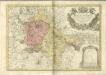
Das Fürstenthum Brieg in Nieder-Schlesien
1 : 460000 Dolní Slezsko Schleuen, Johann David I.D. Schleuen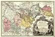
Principatvs Silesiae Bregensis
1 : 145000 Mollova mapová sbírka Wieland, Johann Wolfgang Homann, Johann Baptista - dědici
Principatus Silesiae Wratislaviensis
1 : 129000 Vratislav-oblast (Polsko) Wieland, Johann Wolfgang Schubarth, Matthäus Haeredibus Homannianis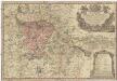
Principatus Silesiae Wratislaviensis
1 : 130000 Vratislav-oblast (Polsko) Wieland, Johann Wolfgang Schubarth, Matthäus ab Haeredibus Homannianis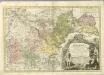

DVCATVS | BRESLANVS | sive | WRATISLAVIENSIS
Amstelædami, Apud Joan. Blaeu

Neisse 91, uit: Special-Karte von Mittel-Europa / nach amtlichen Quellen bearbeitet von W. Liebenow
1 : 300000 titelvariant: W. Liebenow's Mittel-Europa; Annotatie: Titel boven de bladen: W. Liebenow's Mittel-Europa Johannes Wilhelm Liebenow 1822-1897 Frankfurt a. M. : Ludwig Ravenstein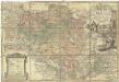
Principatvs Silesiae Oelsnensis in suos districtus Oels Bernstadt et Trebnitz divisi exactissima tabula geographica, exhibens insimul circumjacentes dynastias liberas Trachenberg et Militsch, cum statibus minoribus Freyhain Nevschlos, Goschvtz et Zvlavf
1 : 154000 Oleśnica (Vratislav, Polsko) Wieland, Johann Wolfgang Schubarth, Matthäus Haeretibus Homannianis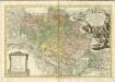

Ducatus Breslanus sive Wratislaviensis. [Karte] Breslaw totius Silesiae Metropolis. [Nebenkarte], in: Novus atlas absolutissimus, Bd. 2, S. 264.
1 Karte aus Atlas Janssonius Offizin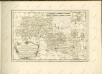

Operations Charte für die ersten Ereignisse des Feldzuges von 1761 in Schlesien
1 : 400000