Maps of Porz

Meßtischblatt 5108 : Wahn im Rheinland, 1948
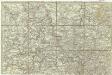
1 : 250000 Wahn im Rheinland. - Aufn. 1893, hrsg. 1895, bericht. 1938, Ausg. 1940. - 1:25000. - Bad Godesberg : HVA, [19]48. - 1 Kt.
Descriptio agri civitatis Coloniensis : cum suis limitibus, terminis, viis, confiniis, interjacentibus, et adjacentibus pagis, villis, castris etc
1 : 60000 Cóvens et Mortier apud I. Cóvens et C. Mortier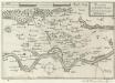
Accurata Territorii Coloniensis Descriptio
Mollova mapová sbírka Person, Nikolaus Person, Nicolas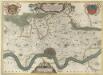
Descriptio Agri Civitatis Coloniensis
1 : 55000 Mollova mapová sbírka Blaeu, Joan Mortier, Pierre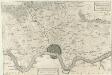
Descritione del distretto della Citta di Colonia con li suoi termini Confini, Villaggi, e Terre &
1 : 55000 Mollova mapová sbírka Hacque, Johann Baptist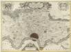
Descriptio Agri Civitatis Coloniensis
1 : 55000 Mollova mapová sbírka Blaeu, Joan Blaeu, Joan I.
DESCRIPTIO AGRI | CIVITATIS COLONIENSIS, | Cum suis limitibus, terminis, viis, confiniis, interjacen- | tibus et adjacentibus Pagis, Villis, Castris, etc.
[Amsterdam : Joan Blaeu]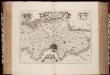
Descriptio agri civitatis Coloniensis : cum suis limitibus, terminis, viis, confiniis, interjacentibus et adjacentibus pagis, villis, castris, etc. / [Joan Blaeu]
1 : 25000 Annotatie: Het eerst verschenen in: Atlas maior, sive Cosmographia Blaviana ... - Amstelaedami : sumptibus Ioannis Blaeu, 1662; Origineel is Blad 72 in atlas factice; Annotatie geografische gegevens: West boven Blaeu, Joan [Amsterdam : Joan Blaeu]
Plan von Coeln u. Umgegend
1 : 25000 Roos Lengfeld
[20] Sect. Cöln, uit: Geologische Karte der Rheinprovinz und der Provinz Westphalen / ausgeführt durch H. von Dechen
1 : 80000 titelvariant: Dechen's geologische Karte vom Rheinland und Westphalen; Annotatie: Titel op bladoverzicht; Incompleet Heinrich von Dechen Berlin : Schropp
123. Cöln a. Rh., uit: Topographische Uebersichtskarte des Deutschen Reiches / herausgegeben v. d. Kartogr. Abt. d. Königl. Preuß. Landesaufnahme
1 : 200000 titelvariant: Topogr. Übersichtskarte des Deutschen Reiches; Annotatie: Titel boven bladen ook: Topogr. Übersichtskarte des Deutschen Reiches; Annotatie geografische gegevens: Op elk blad twee maatstokken: 10 Kilometer = 5,5 cm; 1 geogr. Meile = 3,6 cm; Legenda onder op elk blad Königlich Preußische Landesaufnahme. Kartographische Abtheilung [S.l : Königlich Preußische Landesaufnahme, Kartographische Abtheilung]
84. North Rhine-Westphalia. The World Atlas.
1 : 250000 USSR (Union of Soviet Socialist Republics).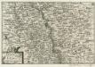
Bonn und Cöln.
1 : 300000 Mollova mapová sbírka Person, Nikolaus Person, Nicolas
Coloniensis archiepiscopatus
1 : 350000 Kolín nad Rýnem-oblast (Německo) Hondius, Henricus apud Henricum Hondium
Carte Nouvelle de la Haute Partie de l'Archevesché et Eslectorat de Cologne Avec ses Enclaves dans les Pays Circomvoisins.
1 : 170000 Mollova mapová sbírka Sanson, Guillaume Ottens, Josua
Le Duché de Berg, le Comté de Homberg, les Seugneries de Hardenberg, et de Wildenborg
1 : 230000 Mollova mapová sbírka Sanson, Guillaume Covens, Johannes I
Le Duché de Berg, le Comté de Homberg, les Seugneries de Hardenberg, et de Wildenborg
1 : 230000 Mollova mapová sbírka Sanson, Guillaume Jaillot, Alexis Hubert
Archiepiscopatus Coloniensis Pars Australis
1 : 260000 Mollova mapová sbírka Gigas, Johann Michael
Archiepiscopatus Coloniensis Pars Australis
1 : 260000 Mollova mapová sbírka Gigas, Johann Michael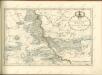

Cöln 84, uit: [W. Liebenow's Special-Karte von Mittel-Europa]
1 : 300000 titelvariant: W. Liebenow's Mittel-Europa; Annotatie: Titel boven de bladen: W. Liebenow's Mittel-Europa Johannes Wilhelm Liebenow 1822-1897 Hannover : Hermann Oppermann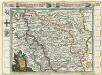
Das Herzogthum Berg hat in die Länge 15 teutsche Meilen und in die dreite 7 =
1 : 690000 Mollova mapová sbírka Baeck, Elias Bäck, Elias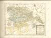

Köln 84, uit: Special-Karte von Mittel-Europa / nach amtlichen Quellen bearbeitet von W. Liebenow
1 : 300000 titelvariant: W. Liebenow's Mittel-Europa; Annotatie: Titel boven de bladen: W. Liebenow's Mittel-Europa Johannes Wilhelm Liebenow 1822-1897 Frankfurt a. M. : Ludwig Ravenstein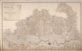
Topographisch-Militairische Karte Des Herzogthums Berg
Wiebeking, Carl Friedrich von; Bechstatt, I. C.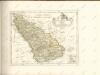

Berge Ducatus Marck Comitatus
1 : 240000 Mollova mapová sbírka Schenk, Pieter Schenk, Peter I
Le Duché De Berg, Le Comté De Homberg, Les Seigneuries De Hardenberg, Et De Wildenborg [Karte], in: Atlas nouveau, contenant toutes les parties du monde [...], Bd. 1, S. 222.
1 Karte aus Atlas Sanson, Nicolas Jaillot, Alexis Hubert und Mortier, Pieter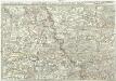
Exactissima totius Vederoviae late sumtae tabula, cujus pars prima est Vederovia stricte sic dicta versus meridiem
1 : 148000 Jülich (Německo) Buna, Wilhelm C.