Maps of Lahntal

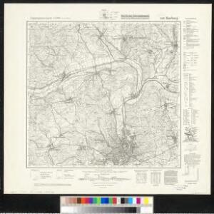
Meßtischblatt 5118 : Marburg, 1942
1 : 250000 Marburg. - Aufn. 1906, hrsg. 1908, letzte Nachtr. 1937, Aus. - 1:25000. - [Berlin]: Reichsamt für Landesaufnahme, 1942. - 1 Kt.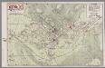
Pharus-Plan Marburg
1 : 8000 Marburg : Elwert [etc.]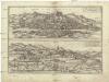
Martpvrgvm vrbs Hassiae metropolis, vniversitate clara
Kassel (Německo) Braun, Georg Hogenberg, Franz
Bewegungen der Alliirten, und Französischen Armee zwischen dem 19ten und 21ten März 1761, nebst Aufstellung und Rückzug der Alliirten am 23ten und 24ten

125. Marburg, uit: Topographische Uebersichtskarte des Deutschen Reiches / herausgegeben v. d. Kartogr. Abt. d. Königl. Preuß. Landesaufnahme
1 : 200000 titelvariant: Topogr. Übersichtskarte des Deutschen Reiches; Annotatie: Titel boven bladen ook: Topogr. Übersichtskarte des Deutschen Reiches; Annotatie geografische gegevens: Op elk blad twee maatstokken: 10 Kilometer = 5,5 cm; 1 geogr. Meile = 3,6 cm; Legenda onder op elk blad Königlich Preußische Landesaufnahme. Kartographische Abtheilung [S.l : Königlich Preußische Landesaufnahme, Kartographische Abtheilung]
Landgrafiatvs Hasso-Cassellanvs typo geographico quatuor Foliorum expressus Cura Homannianorum Heredum Norimb: 1761
1 : 160000 Mollova mapová sbírka Homann, Johann Baptist Homann, Johann Baptista - dědici
Delineatio Geographica generalis comprehendens VI. Foliis Singulos Principatvs Comitatvs Ditiones Dynastias omnes quotquot Imperio Serenissimi Principis Landgrafii Hasso-Darmstadiensis subsunt :
1 : 180000 Mollova mapová sbírka Bronner, Christian Maximilian Homann, Johann Baptista - dědici
Le Landgraviat de Hesse-Cassel Meridional et Septentr: avec une Partie du Landgraviat de Hesse-Darmstat et de la Vetteravie avec autres dependences
1 : 200000 Mollova mapová sbírka Carlet, Louis-François Lotter, Tobias Conrad
Landgraviatus Hassiae Inferioris Comitatvs Waldeciae Eichsfeldiae Tabvla Geographica
1 : 140000 Mollova mapová sbírka Berger, Daniel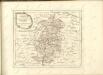

Wetzlar 85, uit: [W. Liebenow's Special-Karte von Mittel-Europa]
1 : 300000 titelvariant: W. Liebenow's Mittel-Europa; Annotatie: Titel boven de bladen: W. Liebenow's Mittel-Europa Johannes Wilhelm Liebenow 1822-1897 Hannover : Hermann Oppermann
Wetzlar 85, uit: Special-Karte von Mittel-Europa / nach amtlichen Quellen bearbeitet von W. Liebenow
1 : 300000 titelvariant: W. Liebenow's Mittel-Europa; Annotatie: Titel boven de bladen: W. Liebenow's Mittel-Europa Johannes Wilhelm Liebenow 1822-1897 Frankfurt a. M. : Ludwig Ravenstein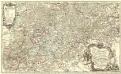
Partie Méridionale du Langraviat de Hesse-Cassel avec une Partie de la Vetteravie
1 : 200000 Mollova mapová sbírka Carlet, Louis-François Coentgen, Heinrich Hugo Broenner, Heinrich Ludwig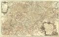
Partie Méridionale du Langraviat de Hesse-Cassel avec une Partie de la Vetteravie
1 : 200000 Mollova mapová sbírka Carlet, Louis-François Coentgen, Heinrich Hugo Broenner, Heinrich Ludwig
Partie méridionale du langraviat de Hesse-Cassel
Hesensko (Německo) Carlet, Louis-François Broglie, Victor-François de chez Henrii Louis Broenner
Das Herzogthum Nassau
1 : 438000 Weimar : Verlag des Geographischen Instituts

Herzogthum Nassau, Landgrafschaft Hessen Homburg und die Freie Stadt Frankfurt
Grosser Hand-Atlas über alle Theile der Erde in 170 Karten Meyer, J. Verlag des Bibliographischen Instituts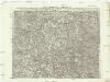
Carte topographique
1 : 215000 Hesensko (Německo) Coentgen, Heinrich Hugo chez I.W.A. Iaeger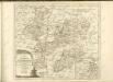

Herzogthum Nassau
1 : 538200 Nasavsko Hoeckner, Carl aus der Schweinfurten Geographischen Gravirsanstalt des Bibliographischen Instituts
NASSOVIA | Comitatus
Salomon Rogiers sculpsit [Amsterdam : Joan Blaeu]
Vestrovaldia ad septentrionem sita in IV. mappis geogr. proposita cum adiac. regionibus cum plurim. privil
1 : 171000 Fulda (Německo) Buna, Wilhelm C. Reinhardt, Andreas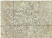
[La baße partie du cercle du Haut-Rhein, divisé en tous ses etats et souverainetes, ou sont le landgraviat de Hesse, les Abbayes de Fulde, et d' Hirschfeld, avec les seigneuries de Wetteravie] et une partie de Westerwald
1 : 171000 Bad Hersfeld (Německo) Buna, Wilhelm C.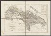
Nassovia Comitatus [Karte], in: Gerardi Mercatoris et I. Hondii Newer Atlas, oder, Grosses Weltbuch, Bd. 1, S. 200.
1 Karte aus Atlas Mercator, Gerhard und Hondius, Jodocus Jansson, Jan
Vestrovaldia ad Septentrionem sita in IV. Mappis Geogr: Proposita cum adiac: Regionibus. cum Plurim: Privil:
1 : 210000 Mollova mapová sbírka Buna, Wilhelm C. Broenner, Heinrich Ludwig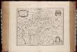
Nassovia comitatus / Salomon Rogiers sculpsit ; Guiljelm. Blaeuw excudit
1 : 300000 Annotatie: Origineel is Blad 104 in atlas factice; Annotatie geografische gegevens: Schaalstokken op de kaart: Miliaria Germanica communia, en: Horae itineris Salomon Rogiers ca 1592- v. 1640; Willem Jansz Blaeu 1571-1638 Amstelodami : Guiljelm. Blaeuw
Nassovia Comitatus. [Karte], in: Theatrum orbis terrarum, sive, Atlas novus, Bd. 1, S. 254.
1 Karte aus Atlas Blaeu, Joan Blaeu, Willem Janszoon
Hassia Landgraviatus
1 : 350000 Mollova mapová sbírka Hondius, Henricus Janssonius, Johannes I