Maps of Hohenroda

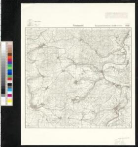
Meßtischblatt 5125 : Friedewald, 1941
1 : 250000 Friedewald. - [Hrsg. 1907, letzte Nachtr. 1939, Ausg. 1941]. - 1:25000. - [Berlin]: Reichsamt für Landesaufnahme, [1941]. - 1 Kt.
Meßtischblatt 2989 : Friedewald, 1872
1 : 250000 Friedewald. - Aufn. 1857. - 1:25000. - [Berlin]: Kgl. Preuss. Landesaufnahme, 1872. - 1 Kt.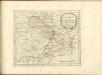

Landgraviatus Hassiae Inferioris Comitatvs Waldeciae Eichsfeldiae Tabvla Geographica
1 : 140000 Mollova mapová sbírka Berger, Daniel
126. Fulda, uit: Topographische Uebersichtskarte des Deutschen Reiches / herausgegeben v. d. Kartogr. Abt. d. Königl. Preuß. Landesaufnahme
1 : 200000 titelvariant: Topogr. Übersichtskarte des Deutschen Reiches; Annotatie: Titel boven bladen ook: Topogr. Übersichtskarte des Deutschen Reiches; Annotatie geografische gegevens: Op elk blad twee maatstokken: 10 Kilometer = 5,5 cm; 1 geogr. Meile = 3,6 cm; Legenda onder op elk blad Königlich Preußische Landesaufnahme. Kartographische Abtheilung [S.l : Königlich Preußische Landesaufnahme, Kartographische Abtheilung]
Landgraviatus Hassiae Inferioris Comitatvs Waldeciae Eichsfeldiae Tabvla Geographica
1 : 140000 Mollova mapová sbírka Berger, Daniel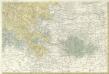
Landgrafiatvs Hasso-Cassellanvs typo geographico quatuor Foliorum expressus Cura Homannianorum Heredum Norimb: 1761
1 : 160000 Mollova mapová sbírka Homann, Johann Baptist Homann, Johann Baptista - dědici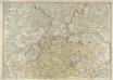
S. R. I. Principatvs Fvldensis in Bvchonia
1 : 210000 Mollova mapová sbírka Homann, Johann Baptist Homann, Johann Baptista
Carte pour servir de suite a la partie meridionale du landgraviat de Hesse-Cassel avec les pays voisins de la Thuringe
Durynsko (Německo) Brönner, Heinrich Ludwig chez Henry Louis Broenner
Le Landgraviat de Hesse-Cassel Meridional et Septentr: avec une Partie du Landgraviat de Hesse-Darmstat et de la Vetteravie avec autres dependences
1 : 200000 Mollova mapová sbírka Carlet, Louis-François Lotter, Tobias Conrad
Eisenach 86, uit: [W. Liebenow's Special-Karte von Mittel-Europa]
1 : 300000 titelvariant: W. Liebenow's Mittel-Europa; Annotatie: Titel boven de bladen: W. Liebenow's Mittel-Europa Johannes Wilhelm Liebenow 1822-1897 Hannover : Hermann Oppermann
112. Cassel, uit: Topographische Uebersichtskarte des Deutschen Reiches / herausgegeben v. d. Kartogr. Abt. d. Königl. Preuß. Landesaufnahme
1 : 200000 titelvariant: Topogr. Übersichtskarte des Deutschen Reiches; Annotatie: Titel boven bladen ook: Topogr. Übersichtskarte des Deutschen Reiches; Annotatie geografische gegevens: Op elk blad twee maatstokken: 10 Kilometer = 5,5 cm; 1 geogr. Meile = 3,6 cm; Legenda onder op elk blad Königlich Preußische Landesaufnahme. Kartographische Abtheilung [S.l : Königlich Preußische Landesaufnahme, Kartographische Abtheilung]
Eisenach 86, uit: Special-Karte von Mittel-Europa / nach amtlichen Quellen bearbeitet von W. Liebenow
1 : 300000 titelvariant: W. Liebenow's Mittel-Europa; Annotatie: Titel boven de bladen: W. Liebenow's Mittel-Europa Johannes Wilhelm Liebenow 1822-1897 Frankfurt a. M. : Ludwig Ravenstein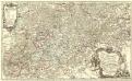
Partie Méridionale du Langraviat de Hesse-Cassel avec une Partie de la Vetteravie
1 : 200000 Mollova mapová sbírka Carlet, Louis-François Coentgen, Heinrich Hugo Broenner, Heinrich Ludwig
Cassel
1 : 300000 R. Mittelbach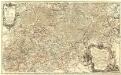
Partie Méridionale du Langraviat de Hesse-Cassel avec une Partie de la Vetteravie
1 : 200000 Mollova mapová sbírka Carlet, Louis-François Coentgen, Heinrich Hugo Broenner, Heinrich Ludwig
Partie méridionale du langraviat de Hesse-Cassel
Hesensko (Německo) Carlet, Louis-François Broglie, Victor-François de chez Henrii Louis Broenner
Buchaviae, sive Fuldensis Ditionis Typus. [Karte], in: Theatrum orbis terrarum, S. 236.
1 Karte aus Atlas Ortelius, Abraham Vrients, Jan Baptista

COMITATVS | HENNEBER- | GENSIS.
[Amsterdam : Joan Blaeu]
Buchaviae, sive Fuldensis Ditionis Typus. [Karte], in: Theatrum orbis terrarum, S. 144.
1 Karte aus Atlas Ortelius, Abraham
Carte pour Servir de Suite à la Partie Meridionale du Landgraviat de Hesse-Cassel avec les pays voisins de la Thüringe
1 : 200000 Mollova mapová sbírka Brönner, Heinrich Ludwig Broenner, Heinrich Ludwig
Hennebergensis Ditionis. vera delineatio [Karte], in: Theatrum orbis terrarum, S. 225.
1 Karte aus Atlas Ortelius, Abraham Vrients, Jan Baptista
Herzogtum Sachsen-Coburg und Gotha 1830 Verwaltungsstruktur
Sachsen-Coburg-Gotha Verwaltung Kunz, Andreas ; Moeschl, Joachim Robert
Herzogtum Sachsen-Coburg und Gotha 1826 Verwaltungsstruktur
Sachsen-Coburg-Gotha Verwaltung Kunz, Andreas ; Moeschl, Joachim Robert
Herzogtum Sachsen-Coburg und Gotha 1834 Verwaltungsstruktur
Sachsen-Coburg-Gotha Verwaltung Kunz, Andreas ; Moeschl, Joachim Robert
Principatus Isenacensis cum adjacentibus vicinorum statuum ditionibus exhibitus
1 : 190000 Durynsko (Německo) Homann, Johann Baptist J. B. Homann
Hassia Landgraviatus
1 : 350000 Mollova mapová sbírka Hondius, Henricus Janssonius, Johannes I