Maps of Friedrichroda

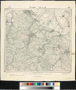
Meßtischblatt 2993 : Waltershausen. Friedrichroda, 1926
1 : 250000 Waltershausen. Friedrichroda. - Aufn. 1905, kleine Nachtr. 1926. - 1:25000. - [Berlin]: Reichsamt für Landesaufnahme, 1926. - 1 Kt.
Meßtischblatt 2993 : Waltershausen. Friedrichroda, 1907
1 : 250000 Waltershausen. Friedrichroda. - Aufn. 1905. - 1:25000. - [Berlin]: Kgl. Preuss. Landesaufnahme, 1907. - 1 Kt.
[Recto], uit: Geognostische Übersichtskarte des Thüringer Waldes / F. Beyschlag
1 : 100000 Annotatie: Omslagtitel Franz Heinrich August Beyschlag 1856-1915 [S.l. : s.n.]
Landgraviatus Hassiae Inferioris Comitatvs Waldeciae Eichsfeldiae Tabvla Geographica
1 : 140000 Mollova mapová sbírka Berger, Daniel
127. Gotha, uit: Topographische Uebersichtskarte des Deutschen Reiches / herausgegeben v. d. Kartogr. Abt. d. Königl. Preuß. Landesaufnahme
1 : 200000 titelvariant: Topogr. Übersichtskarte des Deutschen Reiches; Annotatie: Titel boven bladen ook: Topogr. Übersichtskarte des Deutschen Reiches; Annotatie geografische gegevens: Op elk blad twee maatstokken: 10 Kilometer = 5,5 cm; 1 geogr. Meile = 3,6 cm; Legenda onder op elk blad Königlich Preußische Landesaufnahme. Kartographische Abtheilung [S.l : Königlich Preußische Landesaufnahme, Kartographische Abtheilung]
Gotha Herzogthum.
1 : 200000 Meyer, Joseph, 1796-1856
Der Thüringerwald

Geognostische Karte des Thüringer Waldes. Nordwestliche Hälfte
1 : 200000 Geognostische Karte des Thüringer Waldes Credner, Heinrich Justus Perthes
Geognostische Uebersichtskarte des Thüringer Waldes
1 : 100000 Beyschlag, Franz ; Pütz, M. Simon Schropp
Landgrafiatvs Hasso-Cassellanvs typo geographico quatuor Foliorum expressus Cura Homannianorum Heredum Norimb: 1761
1 : 160000 Mollova mapová sbírka Homann, Johann Baptist Homann, Johann Baptista - dědici
Carte pour servir de suite a la partie meridionale du landgraviat de Hesse-Cassel avec les pays voisins de la Thuringe
Durynsko (Německo) Brönner, Heinrich Ludwig chez Henry Louis Broenner
[Neueste Karte vom Herzogth: Gotha und angränzend: Ländern]
Grosser Hand-Atlas über alle Theile der Erde in 170 Karten Meyer, J. Verlag des Bibliographischen Instituts
Herzogtum Sachsen-Meiningen 1820 Verwaltungsstruktur
Sachsen-Meiningen Verwaltung Kunz, Andreas ; Moeschl, Joachim Robert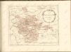

Le Landgraviat de Hesse-Cassel Meridional et Septentr: avec une Partie du Landgraviat de Hesse-Darmstat et de la Vetteravie avec autres dependences
1 : 200000 Mollova mapová sbírka Carlet, Louis-François Lotter, Tobias Conrad
Erfurt
1 : 300000 R. Mittelbach
Principatus Hennenbergensis
1 : 300000 Mollova mapová sbírka Hondius, Henricus Schenk, Peter I
Principatus Hennenbergensis
1 : 300000 Mollova mapová sbírka Hondius, Henricus Janssonius, Johannes I
Fürstentum Schwarzburg-Sondershausen 1820 Verwaltungsstruktur
Schwarzburg-Sondershausen Verwaltung Kunz, Andreas ; Moeschl, Joachim Robert
Tvringiae noviss. descript
1 Karte : Kupferdruck ; 28 x 20 cm Mellinger; Ortelius s.n.
Tvringiae noviss. descript
1 Karte : Kupferdruck ; 28 x 20 cm Mellinger; Ortelius s.n.
Principatus Isenacensis
1 : 210000 Mollova mapová sbírka Homann, Johann Baptist Homann, Johann Baptista
COMITATVS | HENNEBER- | GENSIS.
[Amsterdam : Joan Blaeu]
Special Charte von dem Thüringer Walde
Durynský les (Německo) von dem Geographischen Institute
Carte pour Servir de Suite à la Partie Meridionale du Landgraviat de Hesse-Cassel avec les pays voisins de la Thüringe
1 : 200000 Mollova mapová sbírka Brönner, Heinrich Ludwig Broenner, Heinrich Ludwig
Hennebergensis Ditionis. vera delineatio [Karte], in: Theatrum orbis terrarum, S. 225.
1 Karte aus Atlas Ortelius, Abraham Vrients, Jan Baptista
Hennebergensis Ditionis. vera delineatio [Karte], in: Theatrum orbis terrarum, S. 133.
1 Karte aus Atlas Ortelius, Abraham
Karte des Thüringer-Wald-Gebirges zugleich special Karte des Herzogthums Sachs-Meiningen-Hildburghausen des Fürstenthums Coburg und der Schwarzburgischen Fürstenthümer Rudolstadt und Sondershausen
Grosser Hand-Atlas über alle Theile der Erde in 170 Karten Meyer, J. Verlag des Bibliographischen Instituts