Maps of Burbach

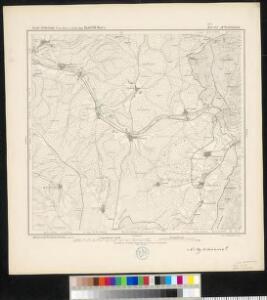
Meßtischblatt 5 : Wildenstein, 1877
1 : 250000 Wildenstein. - Aufn. 1868. - 1:25000. - [Berlin]: Kgl. Preuss. Ministerium f. Handel, 1877. - 1 Kt.
124. Siegen, uit: Topographische Uebersichtskarte des Deutschen Reiches / herausgegeben v. d. Kartogr. Abt. d. Königl. Preuß. Landesaufnahme
1 : 200000 titelvariant: Topogr. Übersichtskarte des Deutschen Reiches; Annotatie: Titel boven bladen ook: Topogr. Übersichtskarte des Deutschen Reiches; Annotatie geografische gegevens: Op elk blad twee maatstokken: 10 Kilometer = 5,5 cm; 1 geogr. Meile = 3,6 cm; Legenda onder op elk blad Königlich Preußische Landesaufnahme. Kartographische Abtheilung [S.l : Königlich Preußische Landesaufnahme, Kartographische Abtheilung]
Section Weilburg, uit: Charte von dem Grossherzogtum Hessen und dem Herzogtum Nassau / trigonometrisch aufgenommen und hrsg. von C.L.P. Eckhardt
1 : 200000 titelvariant: Karte von Hessen und Nassau Eckhardt, C. L. P Darmstadt : Joh. Wilh. Heyer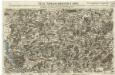
Neue Topographische Carte Der Sieg und Agger von ihrem Ursprunge bis zu ihrem Einflus in den Rhein mit Bemerkung der in dieser Gegend vorgefallenen Kriegsbegebenheiten von 1795 und 1796
Brand, Peter; Schalck, Anna Maria; Coentgen, Georg Joseph Brand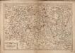
Les Environs De La Lahne depuis Marbvrg iusqu' à Ems avec les pais adiacents
1 : 200000
Wetzlar 85, uit: [W. Liebenow's Special-Karte von Mittel-Europa]
1 : 300000 titelvariant: W. Liebenow's Mittel-Europa; Annotatie: Titel boven de bladen: W. Liebenow's Mittel-Europa Johannes Wilhelm Liebenow 1822-1897 Hannover : Hermann Oppermann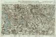
Neue Topographische Carte Der Lahn von Marburg bis zu ihrem Einflus in den Rhein mit Bemerkung der in dieser Gegend vorgefallenen Kriegsbegebenheiten von 1795 und 1796
Brand, Peter; Thum, C.; Schalck, Anna Maria; Coentgen, Georg Joseph Brand u. Thum
Wetzlar 85, uit: Special-Karte von Mittel-Europa / nach amtlichen Quellen bearbeitet von W. Liebenow
1 : 300000 titelvariant: W. Liebenow's Mittel-Europa; Annotatie: Titel boven de bladen: W. Liebenow's Mittel-Europa Johannes Wilhelm Liebenow 1822-1897 Frankfurt a. M. : Ludwig Ravenstein

Das Herzogthum Nassau
1 : 200000 Wimmer, Friedrich Scholz
Nassovia Comitatvs
1 : 1300000 Mollova mapová sbírka Hondius, Henricus Hondius, Henricus
Das Herzogthum Nassau
1 : 438000 Weimar : Verlag des Geographischen Instituts
[21] Sec. Siegen, uit: Geologische Karte der Rheinprovinz und der Provinz Westphalen / ausgeführt durch H. von Dechen
1 : 80000 titelvariant: Dechen's geologische Karte vom Rheinland und Westphalen; Annotatie: Titel op bladoverzicht; Incompleet Heinrich von Dechen Berlin : Schropp
Charte vom Herzogthum Nassau
1 : 200000 Fembo, Christoph
Principatus Nassaviae, divisus in speciales Comitatus, Nassaviam, Hadamariam, Beilstenium, Veilburgum, Dietziam, Usingam, Id Stanium, Dilemburgum et Sigenam ostenduntur
1 : 200000 Mollova mapová sbírka Valk, Gerhard Valck, Gerard

Herzogthum Nassau, Landgrafschaft Hessen Homburg und die Freie Stadt Frankfurt
Grosser Hand-Atlas über alle Theile der Erde in 170 Karten Meyer, J. Verlag des Bibliographischen Instituts
[Kaart], uit: Relief-Panorama des Rheines
titelvariant: Rhein Panorama von Mainz bis Köln; Annotatie: Omslagtitel: Rhein Panorama von Mainz bis Köln Köln-Ehrenfeld : Hoursch & Bechstedt
Partie Orientale Du Temporel De L'Archevesché et Eslectorat De Treves. [Karte], in: Atlas nouveau, contenant toutes les parties du monde [...], Bd. 1, S. 200.
1 Karte aus Atlas Sanson, Nicolas Jaillot, Alexis Hubert und Mortier, Pieter
Herzogthum Nassau
1 : 538200 Nasavsko Hoeckner, Carl aus der Schweinfurten Geographischen Gravirsanstalt des Bibliographischen Instituts
NASSOVIA | Comitatus
Salomon Rogiers sculpsit [Amsterdam : Joan Blaeu]
Vestrovaldia ad septentrionem sita in IV. mappis geogr. proposita cum adiac. regionibus cum plurim. privil
1 : 171000 Fulda (Německo) Buna, Wilhelm C. Reinhardt, Andreas
[La baße partie du cercle du Haut-Rhein, divisé en tous ses etats et souverainetes, ou sont le landgraviat de Hesse, les Abbayes de Fulde, et d' Hirschfeld, avec les seigneuries de Wetteravie] et une partie de Westerwald
1 : 171000 Bad Hersfeld (Německo) Buna, Wilhelm C.
Nassovia Comitatus [Karte], in: Gerardi Mercatoris et I. Hondii Newer Atlas, oder, Grosses Weltbuch, Bd. 1, S. 200.
1 Karte aus Atlas Mercator, Gerhard und Hondius, Jodocus Jansson, Jan
Vestrovaldia ad Septentrionem sita in IV. Mappis Geogr: Proposita cum adiac: Regionibus. cum Plurim: Privil:
1 : 210000 Mollova mapová sbírka Buna, Wilhelm C. Broenner, Heinrich Ludwig
Nassovia comitatus / Salomon Rogiers sculpsit ; Guiljelm. Blaeuw excudit
1 : 300000 Annotatie: Origineel is Blad 104 in atlas factice; Annotatie geografische gegevens: Schaalstokken op de kaart: Miliaria Germanica communia, en: Horae itineris Salomon Rogiers ca 1592- v. 1640; Willem Jansz Blaeu 1571-1638 Amstelodami : Guiljelm. Blaeuw
Nassovia Comitatus. [Karte], in: Theatrum orbis terrarum, sive, Atlas novus, Bd. 1, S. 254.
1 Karte aus Atlas Blaeu, Joan Blaeu, Willem Janszoon
Carte topographique de Wesphalie et de quelsques pays voisins
1 : 225000 Kolín nad Rýnem (Německo) Coentgen, Heinrich Hugo chez I.W.A. Iaeger
Nassovia Comitatus [Karte], in: Novus atlas absolutissimus, Bd. 2, S. 162.
1 Karte aus Atlas Janssonius Offizin