Maps of Strzelin

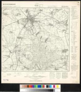
Meßtischblatt 5268 : Strehlen, 1938
1 : 250000 Strehlen. - Aufn. 1883, hrsg. 1884, bericht. 1937. - 1:25000. - [Berlin]: Reichsamt für Landesaufnahme, 1938. - 1 Kt.
Meßtischblatt 3078 : Strehlen, 1937
1 : 250000 Strehlen. - Hrsg. 1884, bericht. 1932, gedr. [19]37. - 1:25000. - [Berlin]: Reichsamt für Landesaufnahme, 1937. - 1 Kt.
Meßtischblatt 3079 : Marienau, 1932
1 : 250000 Marienau. - Hrsg. 1884, bericht. 1932. - 1:25000. - [Berlin]: Reichsamt für Landesaufnahme, 1932. - 1 Kt.
Special-Carte des Fürstenthums Grotkau oder Neisse in Ober-Schlesien, an den Böhmischen und Mährischen Grentzen
Mollova mapová sbírka Schleuen, Johann David Schleuen, Johann David
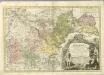
Dvcatvs Silesiae Grotganvs cum Districtu Episcopali Nissensi
1 : 315000 Mollova mapová sbírka Scultetus, Johannes Schenk, Peter I
Dvcatvs Silesiae Grotganvs cum Districtu Episcopali Nissensi
1 : 315000 Mollova mapová sbírka Scultetus, Johannes Blaeu, Joan I.
133. Schweidnitz, uit: Topographische Uebersichtskarte des Deutschen Reiches / herausgegeben v. d. Kartogr. Abt. d. Königl. Preuß. Landesaufnahme
1 : 200000 titelvariant: Topogr. Übersichtskarte des Deutschen Reiches; Annotatie: Titel boven bladen ook: Topogr. Übersichtskarte des Deutschen Reiches; Annotatie geografische gegevens: Op elk blad twee maatstokken: 10 Kilometer = 5,5 cm; 1 geogr. Meile = 3,6 cm; Legenda onder op elk blad Königlich Preußische Landesaufnahme. Kartographische Abtheilung [S.l : Königlich Preußische Landesaufnahme, Kartographische Abtheilung]
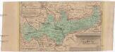
Das Fürstenthum Brieg in Nieder-Schlesien
1 : 460000 Dolní Slezsko Schleuen, Johann David I.D. Schleuen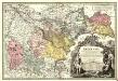
Principatvs Silesiae Bregensis
1 : 145000 Mollova mapová sbírka Wieland, Johann Wolfgang Homann, Johann Baptista - dědici
DVCATVS SILESIÆ | GROTGANVS | cum Districtu Episcopali | NISSENSI
Amstelædami J. Blaeu excudit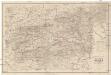
Special Karte der Grafschaft Glatz nebst angrenzenden Theilen von Böhmen und Mähren etc
1 : 150000 Kladsko-oblast (Polsko) Liebenow, W. Eduard Trewendt

Ducatus Silesiae Grotganus cum Districtu Episcopali Nissensi [Karte], in: Novus atlas absolutissimus, Bd. 2, S. 270.
1 Karte aus Atlas Janssonius Offizin

Neisse 91, uit: Special-Karte von Mittel-Europa / nach amtlichen Quellen bearbeitet von W. Liebenow
1 : 300000 titelvariant: W. Liebenow's Mittel-Europa; Annotatie: Titel boven de bladen: W. Liebenow's Mittel-Europa Johannes Wilhelm Liebenow 1822-1897 Frankfurt a. M. : Ludwig Ravenstein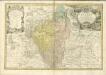

Ducatus Breslanus sive Wratislaviensis. [Karte] Breslaw totius Silesiae Metropolis. [Nebenkarte], in: Novus atlas absolutissimus, Bd. 2, S. 264.
1 Karte aus Atlas Janssonius Offizin

Karte der Umgegend von Gräfenberg
1 : 110000 Lázně Jeseník (Česko) Hennings, Th. Th. Hennings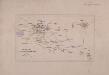
Operations Charte für die ersten Ereignisse des Feldzuges von 1761 in Schlesien
1 : 400000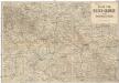
Karte vom Riesen-Gebirge und Grafschaft Glatz
1 : 250000 Kladsko-oblast (Polsko) Albert Goldschmidt
Die Grafschaft Glaz in zwei Abtheilungen zum Breslauer Regierungs Bezirg gehörig
1 : 190000 Kladsko-oblast (Polsko) Schilling F.E.C. Leuckart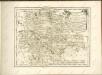

Reisekarte für die Umgebung von Adersbach und Wekelsdorf
1 : 853000 Adršpach (Česko : oblast) Carl André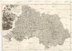
PROVINCIA REGINOHRADECENSIS et COMITATUS GLACENSIS
Hradec Králové-oblast (Česko) Bernardi, Augustin Augustin Bernardi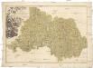
Provincia Reginohradecensis et comitatus Glacensis
Kladsko-oblast (Polsko) Müller, Johann Christoph Winkler
Übersichts Charte de Winterquartiere der beiden Armeen an der böhmisch-schlesischen Grenze im Winter 1760/61
1 : 600000