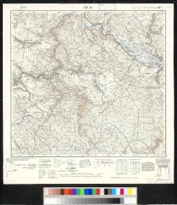
Maps of Zöblitz

Meßtischblatt 5345 : Zöblitz, 1937
1 : 250000 Zöblitz. - Umdr.-Ausg., aufgen. 1914/20, hrsg. 1926, einz. Nachtr. 1934. - 1:25000. - Leipzig, 1937. - 1 Kt.

III. vojenské mapování 3750
1 : 75000
Sebastiansberg und Sächs. Annaberg
1 : 75000 Hora Svatého Šebestiána-oblast (Česko) K. u. k. Militärgeographisches Institut
Sebastiansberg und Sächs. Annaberg
1 : 75000 Čechy (Česko) Brunner, J. K. u. k. Militärgeographisches Institut
Podrobná mapa Království českého
1 : 100000 Hora Svaté Kateřiny (Česko : oblast) Srp, Jan Jaroslav Bursík
Nová Mapa království Českého
1 : 200000 Čechy severozápadní (Česko) Kotyška, Václav Hanf, Norbert Bursík & Kohout
Hora Sv. Šebestiána
1 : 75000 Hora Svatého Šebestiána (Česko) Vojenský zeměpisný ústav
Hora Sv. Šebestiána
1 : 75000 Hora Svatého Šebestiána-oblast (Česko) Vojenský zeměpisný ústav
Hora Sv. Šebestiána
1 : 75000 Hora Svatého Šebestiána (Česko) Vojenský zeměpisný ústav
Hauungsplan-Karte der Hochwaldungen von der gräflich von Buquoy-Rottenhanschen Domaine Rothenhaus in Böhmen
1 : 35200 Červený Hrádek (Jirkov, Chomutov, Česko) Wagner, Jos.
[Kartenblatt]
1 : 25000 Hora Svatého Šebestiána-oblast (Česko) Reichsamt für Landesaufnahme
III. vojenské mapování 3750/4
1 : 25000
III. vojenské mapování 3750/4
1 : 25000
Kallich - c2980-1-005 - Kaiserpflichtexemplar der Landkarten des stabilen Katasters
1 : 2880
Kallich - c2980-1-001 - Kaiserpflichtexemplar der Landkarten des stabilen Katasters
1 : 2880
Kallich - c2980-1-002 - Kaiserpflichtexemplar der Landkarten des stabilen Katasters
1 : 2880
Kallich - c2980-1-007 - Kaiserpflichtexemplar der Landkarten des stabilen Katasters
1 : 2880
Kallich - c2980-1-004 - Kaiserpflichtexemplar der Landkarten des stabilen Katasters
1 : 2880
Kallich - c2980-1-003 - Kaiserpflichtexemplar der Landkarten des stabilen Katasters
1 : 2880
Kallich - c2980-1-006 - Kaiserpflichtexemplar der Landkarten des stabilen Katasters
1 : 2880
Kallich - c2980-1-008 - Kaiserpflichtexemplar der Landkarten des stabilen Katasters
1 : 2880
Sebastianberg und Sachs. Annaberg.
from Spezialkarte der osterreichisch-ungarischen Monarchie.
Umgebungen von Kommotau und Saaz
1 : 750000 Chomutov (Česko : oblast) K. k. militär-geographisches Institut
Umgebungen von Kommotau und Saaz
Chomutov-oblast (Česko) Gargani, Ludwig
Umgebungen von Kommotau und Saaz
Chomutov-oblast (Česko) Gargani, Ludwig K. u. k. Militärgeographisches Institut
Uebersichtskarte des Nordwestböhmischen Braunkohlenbeckens
1 : 144000 Chomutov (Česko : oblast) Adolf Becker
II. vojenské mapování 6
1 : 144000
Generalkarte der Bezirkshauptmannschaft Komotau
1 : 220000 Chomutov-oblast (Česko) Wagner, Jan Eduard F. Kytka