Maps of Rogów

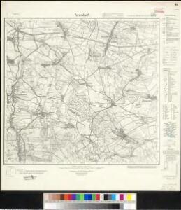
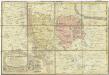
Meßtischblatt 3138 : Arnsdorf, 1934
1 : 250000 Arnsdorf. - Hrsg. 1884, einz. Nachtr. 1912, gedr. [19]34. - 1:25000. - [Berlin]: Reichsamt für Landesaufnahme, 1934. - 1 Kt.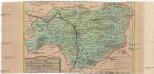
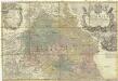
Special-Carte des Fürstenthums Grotkau oder Neisse, in Ober-Schlesien, an den böhmischen und mährische[n] Grentzen
1 : 300000 Grodków-oblast (Polsko) Wieland, Johann Wolfgang Schleuen, Johann David I.D. Schleuen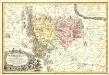
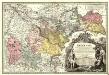
Principatvs Silesiae Mvnsterbregensis exactissima Tabula Geographica exhibens :
1 : 870000 Mollova mapová sbírka Wieland, Johann Wolfgang Homann, Johann Baptista - dědici
Special-Carte des Fürstenthums Grotkau oder Neisse in Ober-Schlesien, an den Böhmischen und Mährischen Grentzen
Mollova mapová sbírka Schleuen, Johann David Schleuen, Johann David
Reymann ́s Special Karte 171 Neisse
Principatvs Silesiae Mvnsterbergensis exactissima tabula geographica exhibens circulos ejusdem Mvnsterberg et Frankenstein una cum adjacentibus civitatibus Reichenstein et Silberberg ad principatum bregensem alias pertinentibus
1 : 100000 Slezsko Wieland, Johann Wolfgang Schubarth, Matthäus Homannianos Heredes
171 Neisse, uit: Topographische Special-Karte von Deutschland (von Central-Europa) / begründet von D.G. Reymann ; [entworfen und gezeichn. von Heinrich Berghaus... [et al.]]
1 : 200000 Annotatie: Lit.: Daniel Gottlob Reymann und die "Topographische Special-Karte von Deutschland" / von Wolfgang Scharfe, in: Kartographische Nachrichten, 39 (1989), Heft I, p. 1-10; Handgeschreven titel: Reymann's Deutschland : 24 Sectionen: Jena, Penig, Dresden, Zittau, Hirschberg, Breslau, Brieg, Andernach, Coblenz, Giessen, Fulda, Schleusingen, Plauen, Zwickau, Teplitz, Jung Bunzlau, Hohenelbe, Glatz, Neisse, Simmern, Prag, Luxemburg, Birkenfeld; Aanwezig: 23 bladen Reymann, Daniel Gottlob; Berghaus, Heinrich [Berlin : 2. Departement des Kriegsministeriums, Bureau für Plan- und Kartenzeichnung]
Dvcatvs Silesiae Grotganvs cum Districtu Episcopali Nissensi
1 : 315000 Mollova mapová sbírka Scultetus, Johannes Schenk, Peter I
Dvcatvs Silesiae Grotganvs cum Districtu Episcopali Nissensi
1 : 315000 Mollova mapová sbírka Scultetus, Johannes Blaeu, Joan I.
133. Schweidnitz, uit: Topographische Uebersichtskarte des Deutschen Reiches / herausgegeben v. d. Kartogr. Abt. d. Königl. Preuß. Landesaufnahme
1 : 200000 titelvariant: Topogr. Übersichtskarte des Deutschen Reiches; Annotatie: Titel boven bladen ook: Topogr. Übersichtskarte des Deutschen Reiches; Annotatie geografische gegevens: Op elk blad twee maatstokken: 10 Kilometer = 5,5 cm; 1 geogr. Meile = 3,6 cm; Legenda onder op elk blad Königlich Preußische Landesaufnahme. Kartographische Abtheilung [S.l : Königlich Preußische Landesaufnahme, Kartographische Abtheilung]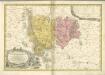

Sbírka map a diagramů použitých na mírových konferencích v Paříži v letech 1919 - 1920
Principatvs Silesiae Bregensis
1 : 145000 Mollova mapová sbírka Wieland, Johann Wolfgang Homann, Johann Baptista - dědici
DVCATVS SILESIÆ | GROTGANVS | cum Districtu Episcopali | NISSENSI
Amstelædami J. Blaeu excudit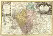
Principatvs Silesiae Grotkani exactissima Tabula geographica exhibens Terram Nissensem simul ac Circulos Grotkau Ottmuchau, et Ziegenhals.
1 : 154000 Mollova mapová sbírka Wieland, Johann Wolfgang Homann, Johann Baptista - dědici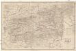
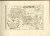
Special Karte der Grafschaft Glatz nebst angrenzenden Theilen von Böhmen und Mähren etc
1 : 150000 Kladsko-oblast (Polsko) Liebenow, W. Eduard Trewendt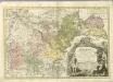

Ducatus Silesiae Grotganus cum Districtu Episcopali Nissensi [Karte], in: Novus atlas absolutissimus, Bd. 2, S. 270.
1 Karte aus Atlas Janssonius Offizin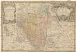
Principatvs Silesiae Grotkani exactissima tabula geographica exhibens terram Nissensem simul ac circulos Grotkau, Ottmuchau, et Ziegenhals
1 : 154000 Gródkow (Polsko) Wieland, Johann Wolfgang Schubarth, Matthäus ab Haeredibus Homannianis
Principatvs Silesiae Grotkani exactissima tabula geographica exhibens terram Nissensem simul ac circulos Grotkau Ottmuchau, et Ziegenhals
1 : 154000 Gródkow (Polsko) Wieland, Johann Wolfgang Schubarth, Matthäus Homannianos Heredes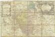
Principatvs Silesiae Grotkani exactissima tabula geographica exhibens terram Nissensem simul ac circulos Grotkau Ottmuchau, et Ziegenhals
1 : 154000 Gródkow (Polsko) Wieland, Johann Wolfgang Schubarth, Matthäus Haeredibus Homannianis
Neisse 91, uit: Special-Karte von Mittel-Europa / nach amtlichen Quellen bearbeitet von W. Liebenow
1 : 300000 titelvariant: W. Liebenow's Mittel-Europa; Annotatie: Titel boven de bladen: W. Liebenow's Mittel-Europa Johannes Wilhelm Liebenow 1822-1897 Frankfurt a. M. : Ludwig Ravenstein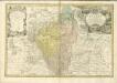

Sbírka map a diagramů použitých na mírových konferencích v Paříži v letech 1919 - 1920

Karte der Umgegend von Gräfenberg
1 : 110000 Lázně Jeseník (Česko) Hennings, Th. Th. Hennings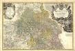
Principatvs Silesiae Oppoloniensis exactissima Tabula geographica, sistens Circvlos Oppoloniensem Ober-Glogav Gros Strehliz, Cosel, Tost, Rosenberg, Falckenberg & Lvblenitz.
1 : 216000 Mollova mapová sbírka Wieland, Johann Wolfgang Homann, Johann Baptista - dědici
Operations Charte für die ersten Ereignisse des Feldzuges von 1761 in Schlesien
1 : 400000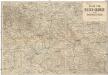
Karte vom Riesen-Gebirge und Grafschaft Glatz
1 : 250000 Kladsko-oblast (Polsko) Albert Goldschmidt