Maps of Selters (Westerwald)

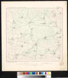
Meßtischblatt 3160 : Selters, 1877
1 : 250000 Selters. - Aufn. 1868. - 1:25000. - [Berlin]: Kgl. Min. f. Handel, 1877. - 1 Kt.
[25] Sect. Coblenz, uit: Geologische Karte der Rheinprovinz und der Provinz Westphalen / ausgeführt durch H. von Dechen
1 : 80000 titelvariant: Dechen's geologische Karte vom Rheinland und Westphalen; Annotatie: Titel op bladoverzicht; Incompleet Heinrich von Dechen Berlin : Schropp
Le Flambeau de la Guerre Allumee au Rhin
Mollova mapová sbírka Delisle, Guillaume Schenk, Peter II
161 Coblenz, uit: Topographische Special-Karte von Deutschland (von Central-Europa) / begründet von D.G. Reymann ; [entworfen und gezeichn. von Heinrich Berghaus... [et al.]]
1 : 200000 Annotatie: Lit.: Daniel Gottlob Reymann und die "Topographische Special-Karte von Deutschland" / von Wolfgang Scharfe, in: Kartographische Nachrichten, 39 (1989), Heft I, p. 1-10; Handgeschreven titel: Reymann's Deutschland : 24 Sectionen: Jena, Penig, Dresden, Zittau, Hirschberg, Breslau, Brieg, Andernach, Coblenz, Giessen, Fulda, Schleusingen, Plauen, Zwickau, Teplitz, Jung Bunzlau, Hohenelbe, Glatz, Neisse, Simmern, Prag, Luxemburg, Birkenfeld; Aanwezig: 23 bladen Reymann, Daniel Gottlob; Berghaus, Heinrich [Berlin : 2. Departement des Kriegsministeriums, Bureau für Plan- und Kartenzeichnung]
124. Siegen, uit: Topographische Uebersichtskarte des Deutschen Reiches / herausgegeben v. d. Kartogr. Abt. d. Königl. Preuß. Landesaufnahme
1 : 200000 titelvariant: Topogr. Übersichtskarte des Deutschen Reiches; Annotatie: Titel boven bladen ook: Topogr. Übersichtskarte des Deutschen Reiches; Annotatie geografische gegevens: Op elk blad twee maatstokken: 10 Kilometer = 5,5 cm; 1 geogr. Meile = 3,6 cm; Legenda onder op elk blad Königlich Preußische Landesaufnahme. Kartographische Abtheilung [S.l : Königlich Preußische Landesaufnahme, Kartographische Abtheilung]
Section Weilburg, uit: Charte von dem Grossherzogtum Hessen und dem Herzogtum Nassau / trigonometrisch aufgenommen und hrsg. von C.L.P. Eckhardt
1 : 200000 titelvariant: Karte von Hessen und Nassau Eckhardt, C. L. P Darmstadt : Joh. Wilh. Heyer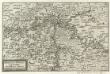
Mosella et Rheni Confluxus
Mollova mapová sbírka Person, Nikolaus Person, Nicolas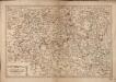
Les Environs De La Lahne depuis Marbvrg iusqu' à Ems avec les pais adiacents
1 : 200000
Pars Vederoviae plvrimas ditiones princ. et com. Nassovicor. imprimis verô regionem Schwalbacensem acidulis claram exhibens accurate distincta
Hesensko (Německo) Homann, Johann Baptist J. B. Homann
Pars Vederoviae Plurimas Ditiones Princ. et Com. Nassovicor. imprimis verô Regionem Schwalbacensem Acidulis claram
1 : 170000 Mollova mapová sbírka Homann, Johann Baptist Homann, Johann Baptista
Nassoviae Principatus et ad cum spectantes Ditiones
1 : 180000 Mollova mapová sbírka Seutter, Matthäus Seutter, Matthäus
Mappa geographica exhibens principatum Nassoviae
1 : 172000 Nasavsko Lotter, Tobias Conrad Lotter, Georg F. sumptibus et curis Tobiae Conradi Lotter
Nassovia principatus, cum omnibus ei pertinentibus comitatibus dominiiis, ac praefecturis, ut et confiniis intrá Lahnum, Rhenum et Moenum flumina
1 : 1500000 ad situm verum exacte delineatus â Joh. Jac. Stetter [...] excudit Nic. Visscheri vidua Amstelodami : nunc apud Petrum Schenk Iunior
Partie Orientale du Temporel, de l'Archevesché et Eslectorat de Treves
1 : 220000 Mollova mapová sbírka Sanson, Guillaume Jaillot, Alexis Hubert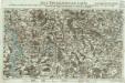
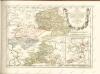
Neue Topographische Carte Der Lahn von Marburg bis zu ihrem Einflus in den Rhein mit Bemerkung der in dieser Gegend vorgefallenen Kriegsbegebenheiten von 1795 und 1796
Brand, Peter; Thum, C.; Schalck, Anna Maria; Coentgen, Georg Joseph Brand u. Thum
Partie Orientale Du Temporel De L'Archevesché et Eslectorat, De Treves
1 : 210000 Mollova mapová sbírka Sanson, Guillaume Jaillot, Alexis Hubert
Nassau, Hessen-Homburg, Frankfurt.
1 : 344000 Flemming, Carl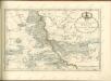

Das Herzogthum Nassau
1 : 200000 Wimmer, Friedrich Scholz
Nassovia Comitatvs
1 : 1300000 Mollova mapová sbírka Hondius, Henricus Hondius, Henricus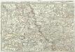
Exactissima totius Vederoviae late sumtae tabula, cujus pars prima est Vederovia stricte sic dicta versus meridiem
1 : 148000 Jülich (Německo) Buna, Wilhelm C.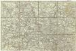
[Exactissima totius Vederoviae late sumtae tabula, cujus pars prima est Vederovia stricte sic dicta versus meridiem]
1 : 148000 Jülich (Německo) Buna, Wilhelm C.
Das Herzogthum Nassau
1 : 438000 Weimar : Verlag des Geographischen Instituts
[21] Sec. Siegen, uit: Geologische Karte der Rheinprovinz und der Provinz Westphalen / ausgeführt durch H. von Dechen
1 : 80000 titelvariant: Dechen's geologische Karte vom Rheinland und Westphalen; Annotatie: Titel op bladoverzicht; Incompleet Heinrich von Dechen Berlin : Schropp
Charte vom Herzogthum Nassau
1 : 200000 Fembo, Christoph
Principatus Nassaviae, divisus in speciales Comitatus, Nassaviam, Hadamariam, Beilstenium, Veilburgum, Dietziam, Usingam, Id Stanium, Dilemburgum et Sigenam ostenduntur
1 : 200000 Mollova mapová sbírka Valk, Gerhard Valck, Gerard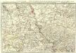
Exactissima totius Vederoviae laté sumtae Tabula
1 : 210000 Mollova mapová sbírka Buna, Wilhelm C. Broenner, Heinrich Ludwig