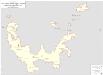
Maps of Probstzella

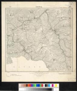
Meßtischblatt 5434 : Leutenberg, 1953
1 : 250000 Leutenberg. - Hrsg. 1905, letzte Nachtr. 1907, gedr. [19]33, redakt. Änd. 1953. - 1:25000. - [Berlin]: MdI, 1953. - 1 Kt.
Meßtischblatt 3182 : Leutenberg, 1933
1 : 250000 Leutenberg. - Aufn. 1903, hrsg. 1905, einz. Nachtr. 1907, gedr. [19]33. - 1:25000. - [Berlin]: Reichsamt für Landesaufnahme, 1933. - 1 Kt.
Meßtischblatt 5434 : Leutenberg, 1907
1 : 250000 Leutenberg. - Aufn. 1903, hrsg. 1905, einz. Nachtr. 1907. - 1:25000. - [Berlin]: Kgl. Preuss. Landesaufnahme, 1907. - 1 Kt.
128. Jena, uit: Topographische Uebersichtskarte des Deutschen Reiches / herausgegeben v. d. Kartogr. Abt. d. Königl. Preuß. Landesaufnahme
1 : 200000 titelvariant: Topogr. Übersichtskarte des Deutschen Reiches; Annotatie: Titel boven bladen ook: Topogr. Übersichtskarte des Deutschen Reiches; Annotatie geografische gegevens: Op elk blad twee maatstokken: 10 Kilometer = 5,5 cm; 1 geogr. Meile = 3,6 cm; Legenda onder op elk blad Königlich Preußische Landesaufnahme. Kartographische Abtheilung [S.l : Königlich Preußische Landesaufnahme, Kartographische Abtheilung]
Delineatio geographica territorii celsissimorum S.R.I. comitum Ruthenorum de Plauen utriusque lineae senioris nempe ac iunioris, partem Vogtlandiae, olim ac hodie sic dictae constituensis
1 : 140000 Plauen (Německo) impensis Homannianorum Heredum
Herzogtum Sachsen-Coburg-Saalfeld 1820 Verwaltungsstruktur [mit] Fürstentum Lichtenberg
Sachsen-Coburg-Saalfeld Verwaltung Kunz, Andreas ; Moeschl, Joachim Robert
Regiae Celsitudini Serenissimo Principi ac Domino Friderico Christiano Leopoldo
1 : 200000 Mollova mapová sbírka Zollmann, Johann Wilhelm Oetinger, Christ. Friedrich Homann, Johann Baptista - dědici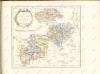

Fürstentum Schwarzburg-Rudolstadt 1823 Verwaltungsstruktur
Schwarzburg-Rudolstadt Verwaltung Kunz, Andreas ; Moeschl, Joachim Robert
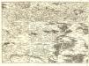
Terra Advocatorvm Vulgo Voightland
1 : 290000 Mollova mapová sbírka Örnehufvud, Olof Hansson Blaeu, Joan I.
Fürstentum Schwarzburg-Rudolstadt 1820 Verwaltungsstruktur
Schwarzburg-Rudolstadt Verwaltung Kunz, Andreas ; Moeschl, Joachim Robert
Coburg
1 : 300000 R. Mittelbach
Fürstentum Schwarzburg-Sondershausen 1820 Verwaltungsstruktur
Schwarzburg-Sondershausen Verwaltung Kunz, Andreas ; Moeschl, Joachim Robert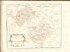
S.R.Imp. Circuli Franconici Geographica Delineatio Francken-Land mit Seinen Gräntzen
Mollova mapová sbírka Endter, Wolfgang Moritz Endter, Wolfgang Moritz
Terra Advocatorvm vulgo Voightland
1 : 290000 Vogtland (Německo) Örnehufvud, Olof Hansson Blaeu, Joan J. Blaeu
TERRA ADVOCATORVM | Vulgo | VOIGHTLAND
Descripta ab Olao Ioannis Gotho | S.R.M. Sueciæ Geographo. Amstelædami | J. Blaeu excudebat.
Principatus Isenacensis
1 : 210000 Mollova mapová sbírka Homann, Johann Baptist Homann, Johann Baptista
Special Charte von dem Thüringer Walde
Durynský les (Německo) von dem Geographischen Institute
Carte pour Servir de Suite à la Partie Meridionale du Landgraviat de Hesse-Cassel avec les pays voisins de la Thüringe
1 : 200000 Mollova mapová sbírka Brönner, Heinrich Ludwig Broenner, Heinrich Ludwig
Zu den Operationen der Generale Syburg, Schenkendorf und Linden gegen die Reichsarmee, vom 15ten Februar bis zum 5ten April 1761

Karte des Thüringer-Wald-Gebirges zugleich special Karte des Herzogthums Sachs-Meiningen-Hildburghausen des Fürstenthums Coburg und der Schwarzburgischen Fürstenthümer Rudolstadt und Sondershausen
Grosser Hand-Atlas über alle Theile der Erde in 170 Karten Meyer, J. Verlag des Bibliographischen Instituts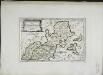
Des Bisthums Bamberg nördliche Aemter
1 Karte : Kupferdruck ; 19 x 29 cm Reilly F. J. J. von Reilly
Tvringiae Noviss. descript.
1 : 520000 Mollova mapová sbírka Mellinger, Johann Plantin, Christoph (officina)
Thuringer-Wald-Gebirges.
1 : 380000 Grassl, J. (Joseph)
Principatus Isenacensis cum adjacentibus vicinorum statuum ditionibus exhibitus
1 : 190000 Durynsko (Německo) Homann, Johann Baptist J. B. Homann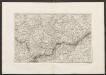
Militair Karte von Süd-Deutschland in 20 Sectionen
1 : 400000 3. Section Coulon, Alois von A. von Coulon
Geographische Charte
1 : 300000 Mollova mapová sbírka Zollmann, Friedrich