Maps of Crottendorf

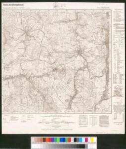
Meßtischblatt 5443 : Buchholz, 1944
1 : 250000 Buchholz. - Aufn. 1914, 1919 u. 1920, hrsg. 1924, bericht. 1936, Ausg. 1943. - 1:25000. - Leipzig, 1944. - 1 Kt.
Meßtischblatt 5443 : Buchholz, 1942
1 : 250000 Buchholz. - Aufn. 1914, 1919 u. 1920, hrsg. 1924, bericht. 1936. - 1:25000. - Leipzig, 1942. - 1 Kt.
[Kartenblatt]
1 : 25000 Annaberg-Buchholz (Německo) Reichsamt für Landesaufnahme
Fichtelberggebiet

III. vojenské mapování 3750
1 : 75000
Mapy plánování ČSR
Nová Mapa království Českého
1 : 200000 Čechy severozápadní (Česko) Kotyška, Václav Hanf, Norbert Bursík & Kohout
Sebastiansberg und Sächs. Annaberg
1 : 75000 Hora Svatého Šebestiána-oblast (Česko) K. u. k. Militärgeographisches Institut
Sebastiansberg und Sächs. Annaberg
1 : 75000 Čechy (Česko) Brunner, J. K. u. k. Militärgeographisches Institut
Hora Sv. Šebestiána
1 : 75000 Hora Svatého Šebestiána (Česko) Vojenský zeměpisný ústav
Hora Sv. Šebestiána
1 : 75000 Hora Svatého Šebestiána-oblast (Česko) Vojenský zeměpisný ústav
Hora Sv. Šebestiána
1 : 75000 Hora Svatého Šebestiána (Česko) Vojenský zeměpisný ústav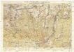
Wander- und Wintersportkarte des Erzgebirges
1 : 30000 Fichtelberg (Krušné hory, Německo : hora) G.A. Kaufmanns Buchhandlung
III. vojenské mapování 3850/1, 3750/3
1 : 25000

Sebastianberg und Sachs. Annaberg.
from Spezialkarte der osterreichisch-ungarischen Monarchie.
Kahle's Höhenschichtenkarte des Erzgebirges
1 : 100000 Krušné hory (Česko a Německo) Hofbuchdruckerei H. Kahle
166 Zwickau, uit: Topographische Special-Karte von Deutschland (von Central-Europa) / begründet von D.G. Reymann ; [entworfen und gezeichn. von Heinrich Berghaus... [et al.]]
1 : 200000 Annotatie: Lit.: Daniel Gottlob Reymann und die "Topographische Special-Karte von Deutschland" / von Wolfgang Scharfe, in: Kartographische Nachrichten, 39 (1989), Heft I, p. 1-10; Handgeschreven titel: Reymann's Deutschland : 24 Sectionen: Jena, Penig, Dresden, Zittau, Hirschberg, Breslau, Brieg, Andernach, Coblenz, Giessen, Fulda, Schleusingen, Plauen, Zwickau, Teplitz, Jung Bunzlau, Hohenelbe, Glatz, Neisse, Simmern, Prag, Luxemburg, Birkenfeld; Aanwezig: 23 bladen Reymann, Daniel Gottlob; Berghaus, Heinrich [Berlin : 2. Departement des Kriegsministeriums, Bureau für Plan- und Kartenzeichnung]
Chemnitz
1 : 120000 Chemnitz-oblast (Německo) Kön. Kameral-Vermessung u. Graviranstalt
129. Chemnitz, uit: Topographische Uebersichtskarte des Deutschen Reiches / herausgegeben v. d. Kartogr. Abt. d. Königl. Preuß. Landesaufnahme
1 : 200000 titelvariant: Topogr. Übersichtskarte des Deutschen Reiches; Annotatie: Titel boven bladen ook: Topogr. Übersichtskarte des Deutschen Reiches; Annotatie geografische gegevens: Op elk blad twee maatstokken: 10 Kilometer = 5,5 cm; 1 geogr. Meile = 3,6 cm; Legenda onder op elk blad Königlich Preußische Landesaufnahme. Kartographische Abtheilung [S.l : Königlich Preußische Landesaufnahme, Kartographische Abtheilung]
Sbírka map a diagramů použitých na mírových konferencích v Paříži v letech 1919 - 1920

Mappa Geographica Circuli Metalliferi Electoratus Saxoniae cum omnibus, quae in eo comprehenduntur Praefecturis et Dynastiis
1 : 170000 Mollova mapová sbírka Lotter, Tobias Conrad Seutter, Matthäus
Charte vom Saazer Kreis im Königreiche Böhmen
Žatec-oblast (Louny, Česko) Berghaus, Heinrich Karl Wilhelm Kutschera, E. E. Kutschera
Mappa geographica circuli Metalliferi electoratus Saxoniae cum omnibus, quae in eo comprehenduntur praefecturis et dynastiis
Sasko (Německo) Seutter, Matthäus Lotter, Tobias Conrad M. Seutter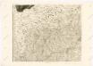
Mappa geographica regni Bohemiae in duodecim circuloc divisae ... Sectio. VI.

Carte von Ertzgebürgischen Creysse in Churfurstenthum Sachssen
1 : 170000 Mollova mapová sbírka Schenk, Pieter Schenk, Peter I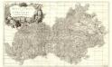
Regio Egrana et Provincia Satecensis
1 : 233000 Mollova mapová sbírka Erber, Bernardinus Winkler, Johann Christoph Kurzböck, Josef von
Der Satzer Creis in dem Königreiche Böhmen gelegen
1 : 530000 Karlovarský kraj (Česko) Schreiber, Johann Georg Joh. George Schreibers see. Wittbe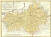
Regni Bohemiae Circulus Satecensis
1 : 225000 Mollova mapová sbírka Müller, Johann Christoph Homann, Johann Baptista - dědici