Maps of Jöhstadt

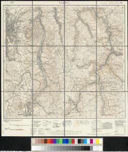
Meßtischblatt 139 : Annaberg, 1935
1 : 250000 Annaberg. - Umdr.-Ausg., aufgen. 1914, 1919 u. 1920, hrsg. 1924, bericht. 1932. - 1:25000. - Leipzig, 1935. - 1 Kt.
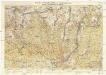
III. vojenské mapování 3750/3
1 : 25000
[Kartenblatt]
1 : 25000 Annaberg-Buchholz (Německo) Reichsamt für Landesaufnahme

[Kartenblatt]
1 : 25000 Hora Svatého Šebestiána-oblast (Česko) Reichsamt für Landesaufnahme
III. vojenské mapování 3750/4
1 : 25000
III. vojenské mapování 3750/4
1 : 25000
III. vojenské mapování 3750/4
1 : 25000
III. vojenské mapování 3750/4
1 : 25000
Christophhammer - c3602-1-007 - Kaiserpflichtexemplar der Landkarten des stabilen Katasters
1 : 2880
Christophhammer - c3602-1-005 - Kaiserpflichtexemplar der Landkarten des stabilen Katasters
1 : 2880
Christophhammer - c3602-1-006 - Kaiserpflichtexemplar der Landkarten des stabilen Katasters
1 : 2880
Christophhammer - c3602-1-001 - Kaiserpflichtexemplar der Landkarten des stabilen Katasters
1 : 2880
Christophhammer - c3602-1-004 - Kaiserpflichtexemplar der Landkarten des stabilen Katasters
1 : 2880
Christophhammer - c3602-1-008 - Kaiserpflichtexemplar der Landkarten des stabilen Katasters
1 : 2880
Christophhammer - c3602-1-003 - Kaiserpflichtexemplar der Landkarten des stabilen Katasters
1 : 2880
Christophhammer - c3602-1-002 - Kaiserpflichtexemplar der Landkarten des stabilen Katasters
1 : 2880
Hora Sv. Šebestiána
1 : 75000 Hora Svatého Šebestiána (Česko) Vojenský zeměpisný ústav
Hora Sv. Šebestiána
1 : 75000 Hora Svatého Šebestiána-oblast (Česko) Vojenský zeměpisný ústav
Hora Sv. Šebestiána
1 : 75000 Hora Svatého Šebestiána (Česko) Vojenský zeměpisný ústav
III. vojenské mapování 3750
1 : 75000
Sebastiansberg und Sächs. Annaberg
1 : 75000 Hora Svatého Šebestiána-oblast (Česko) K. u. k. Militärgeographisches Institut
Sebastiansberg und Sächs. Annaberg
1 : 75000 Čechy (Česko) Brunner, J. K. u. k. Militärgeographisches Institut
Mapy plánování ČSR
Nová Mapa království Českého
1 : 200000 Čechy severozápadní (Česko) Kotyška, Václav Hanf, Norbert Bursík & Kohout
Fichtelberggebiet
Wander- und Wintersportkarte des Erzgebirges
1 : 30000 Fichtelberg (Krušné hory, Německo : hora) G.A. Kaufmanns Buchhandlung
Karte des Bezirkes Pressnitz
1 : 36000 Přísečnice (Česko : zaniklá obec) Hollmann, Victor Josef Mecséry de Tsóor, Karl Johann Friedrich Selner
Weipert (Wayprt) - c8347-1-002 - Kaiserpflichtexemplar der Landkarten des stabilen Katasters
1 : 2880
Weipert (Wayprt) - c8347-1-004 - Kaiserpflichtexemplar der Landkarten des stabilen Katasters
1 : 2880
Weipert (Wayprt) - c8347-1-001 - Kaiserpflichtexemplar der Landkarten des stabilen Katasters
1 : 2880