Maps of Sankt Bernhard

Maps of Sankt Bernhard

$title$

Meßtischblatt 5529 : Haina, 1936

1 : 250000 Haina. - Hrsg. 1906, bericht. 1929, letzte Nachtr. 1936. - 1:25000. - [Berlin]: Reichsamt für Landesaufnahme, 1936. - 1 Kt.
$title$

Meßtischblatt 3233 : Dingsleben, 1873

1 : 250000 Dingsleben. - Aufn. 1856. - 1:25000. - [Berlin]: Kgl. Preuss. Min. f. Handel, 1873. - 1 Kt.
$title$

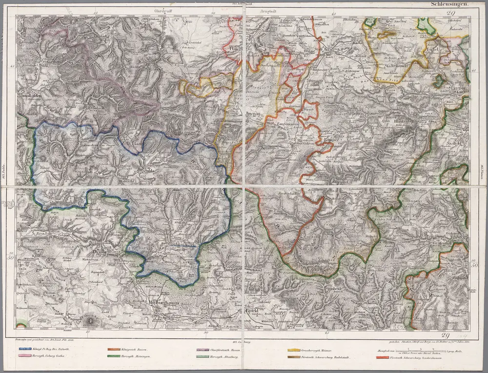
164 Schleusingen, uit: Topographische Special-Karte von Deutschland (von Central-Europa) / begründet von D.G. Reymann ; [entworfen und gezeichn. von Heinrich Berghaus... [et al.]]

1 : 200000 Annotatie: Lit.: Daniel Gottlob Reymann und die "Topographische Special-Karte von Deutschland" / von Wolfgang Scharfe, in: Kartographische Nachrichten, 39 (1989), Heft I, p. 1-10; Handgeschreven titel: Reymann's Deutschland : 24 Sectionen: Jena, Penig, Dresden, Zittau, Hirschberg, Breslau, Brieg, Andernach, Coblenz, Giessen, Fulda, Schleusingen, Plauen, Zwickau, Teplitz, Jung Bunzlau, Hohenelbe, Glatz, Neisse, Simmern, Prag, Luxemburg, Birkenfeld; Aanwezig: 23 bladen Reymann, Daniel Gottlob; Berghaus, Heinrich [Berlin : 2. Departement des Kriegsministeriums, Bureau für Plan- und Kartenzeichnung]
$title$

$title$

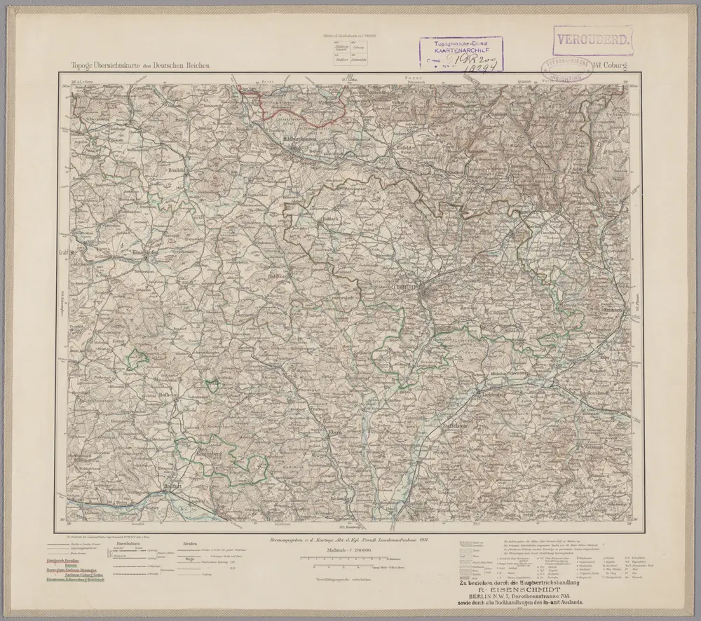
141. Coburg, uit: Topographische Uebersichtskarte des Deutschen Reiches / herausgegeben v. d. Kartogr. Abt. d. Königl. Preuß. Landesaufnahme

1 : 200000 titelvariant: Topogr. Übersichtskarte des Deutschen Reiches; Annotatie: Titel boven bladen ook: Topogr. Übersichtskarte des Deutschen Reiches; Annotatie geografische gegevens: Op elk blad twee maatstokken: 10 Kilometer = 5,5 cm; 1 geogr. Meile = 3,6 cm; Legenda onder op elk blad Königlich Preußische Landesaufnahme. Kartographische Abtheilung [S.l : Königlich Preußische Landesaufnahme, Kartographische Abtheilung]
$title$

$title$

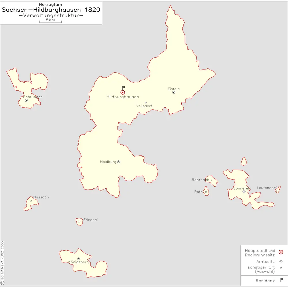
Herzogtum Sachsen-Hildburghausen 1820 Verwaltungsstruktur

Sachsen-Hildburghausen Verwaltung Kunz, Andreas ; Moeschl, Joachim Robert
$title$

Serenissimo Principi ac Domino Domino Ernesto Friderico Dnci. Saxoniae, Juliaci, Cliviae et Montium

1 : 140000 Mollova mapová sbírka Homann, Johann Baptist Homann, Johann Baptista
$title$

$title$

$title$

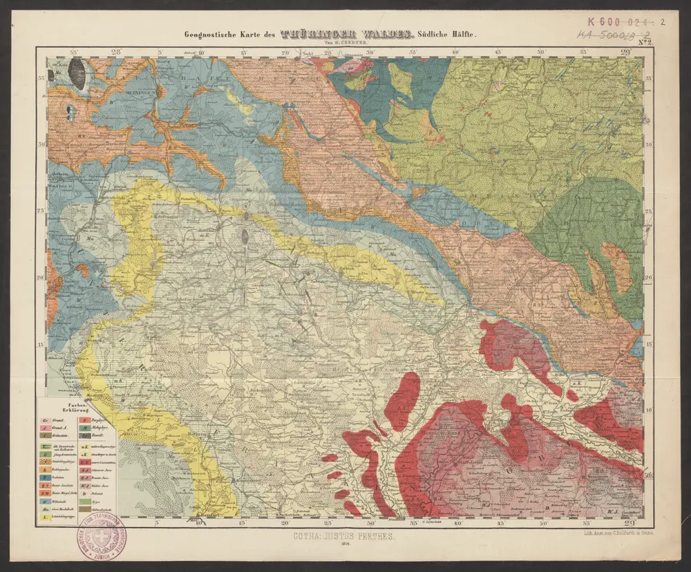
Geognostische Karte des Thüringer Waldes. Südliche Hälfte

1 : 200000 Geognostische Karte des Thüringer Waldes Credner, Heinrich Justus Perthes
$title$

Herzogtum Sachsen-Coburg-Saalfeld 1820 Verwaltungsstruktur [mit] Fürstentum Lichtenberg

Sachsen-Coburg-Saalfeld Verwaltung Kunz, Andreas ; Moeschl, Joachim Robert
$title$

Herzogtum Sachsen-Meiningen 1820 Verwaltungsstruktur

Sachsen-Meiningen Verwaltung Kunz, Andreas ; Moeschl, Joachim Robert
$title$

S. R. I. Comitatvs Henneberg

1 : 150000 Mollova mapová sbírka Zinck, Johann Jacob Homann, Johann Baptista - dědici
$title$

S. R. I. Comitatvs Henneberg

1 : 150000 Mollova mapová sbírka Zinck, Johann Jacob Homann, Johann Baptista - dědici
$title$

Principatus Hennenbergensis

1 : 300000 Mollova mapová sbírka Hondius, Henricus Schenk, Peter I
$title$

Principatus Hennenbergensis

1 : 300000 Mollova mapová sbírka Hondius, Henricus Janssonius, Johannes I
$title$

Coburg

1 : 300000 R. Mittelbach
$title$

S.R.Imp. Circuli Franconici Geographica Delineatio Francken-Land mit Seinen Gräntzen

Mollova mapová sbírka Endter, Wolfgang Moritz Endter, Wolfgang Moritz
$title$

$title$

Reverendissimo Et Celsissimo S. R. I. Principi Constantino Sanctae Fuldensis Ecclesiae Abbati Augustissimae Romanorum Imperatricis Archi-Cancellario Per Germaniam Galliamque Primati Hanc Novam Veteris Buchoniae Tabulam Unacum Suis Confinys Dedicat Consecratque

1 : 340000 Mollova mapová sbírka Schannat, Johann Friedrich Puschner, Johann Georg
$title$

Charte von dem Grosgerzogthum Würzburg, nebst dem Fürstenthum Schwarzenberg, den Grafschafften Castell und Limpurg-Speckfeld, der Herrschafft Wiesentheid &c

1 : 188000 Bavorsko (Německo) Hammer, C. F. bey Homanns Erben
$title$

Principatus Isenacensis

1 : 210000 Mollova mapová sbírka Homann, Johann Baptist Homann, Johann Baptista
$title$

Kissingen 100, uit: Special-Karte von Mittel-Europa / nach amtlichen Quellen bearbeitet von W. Liebenow

1 : 300000 titelvariant: W. Liebenow's Mittel-Europa; Annotatie: Titel boven de bladen: W. Liebenow's Mittel-Europa Johannes Wilhelm Liebenow 1822-1897 Frankfurt a. M. : Ludwig Ravenstein
$title$

COMITATVS | HENNEBER- | GENSIS.

[Amsterdam : Joan Blaeu]
$title$

Sac. Rom. Imperii Principatus & Episcopatus Bambergensis Nova Tabula Geographica

1 : 260000 Mollova mapová sbírka Homann, Johann Baptist Homann, Johann Baptista
$title$

Special Charte von dem Thüringer Walde

Durynský les (Německo) von dem Geographischen Institute
$title$

Hennebergensis Ditionis. vera delineatio [Karte], in: Theatrum orbis terrarum, S. 225.

1 Karte aus Atlas Ortelius, Abraham Vrients, Jan Baptista
$title$

Hennebergensis Ditionis. vera delineatio [Karte], in: Theatrum orbis terrarum, S. 133.

1 Karte aus Atlas Ortelius, Abraham
$title$

Das Bisthum Wurtzburg in Francken

1 : 280000 Mollova mapová sbírka Seyfried, Johann Heinrich Schollenberger, Johann Jakob Hoffmann, Johann
© MapTiler © OpenStreetMap contributors
How does it work?
These instructions will show you how to find historical maps online.
Getting started
Type the place name in the search box to find the exact location. You can further adjust the search by zooming in and out.
Zoom
Zoom in and out with the buttons or use your mouse or touchpad natively.
Exact Area tool
Click here and draw a rectangle over the map to precisely define the search area.
Set filters
Narrow your search with advanced settings, such as Years (from/to), Fulltext, Publisher, etc.
Results
See the results of your search on the right side. You can scroll down to find more maps of this location.
?

Download OldMapsOnline Mobile