Maps of Ellefeld

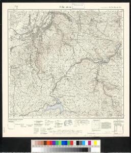
Meßtischblatt 144 : Falkenstein, 1934
1 : 250000 Falkenstein. - Umdr.-Ausg., aufgen. 1921, [hrsg.] 1927, einz. Nachtr. 1934. - 1:25000. - Leipzig, 1934. - 1 Kt.
[Kartenblatt]
1 : 25000 Bublava (Česko) Reichsamt für Landesaufnahme
Graslitz und Johanngeorgenstadt
1 : 75000 Johanngeorgenstadt (Německo : oblast) Höller, K. K. u. k. militär-geographisches Institut
Graslitz und Johanngeorgenstadt
1 : 75000 Johanngeorgenstadt (Německo : oblast) Höller, K. K. u. k. Militärgeographisches Institut
Graslitz und Johanngeorgenstadt
1 : 75000 Johanngeorgenstadt (Německo : oblast) K. u. k. Militärgeographisches Institut
Kraslice
1 : 75000 Kraslice-oblast (Česko) Vojenský zeměpisný ústav
Graslitz und Johanngeorgenstadt.
from Spezialkarte der osterreichisch-ungarischen Monarchie.
Umgebungen von Neudek
Nejdek-oblast (Karlovy Vary, Česko) Kiss, Josef K. u. k. Militärgeographisches Institut
III. vojenské mapování 3849
1 : 75000
Mapy plánování ČSR

Soubor přehledných map pro plánování a statistiku: 3849 – Kraslice
Müllerova mapa Čech
1 : 132000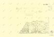
III. vojenské mapování 3849/1
1 : 25000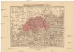
Generalkarte der Bezirkshauptmannschaft Graslitz
1 : 220000 Kraslice-oblast (Česko) Wagner, Jan Eduard F. Kytka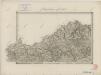
II. vojenské mapování 5
1 : 144000
Der Voigtlaendische Kreis
1 : 50000 Sasko (Německo) Riedig, Christian G. Leutenan, H. Schreibers Erben
Geographischer Entwurff der Stadt und Gegend des Welt berühmten Kaeyser Carlsbades in Königreich Böhmen, vorstellent den Ellenbognischen Creiß
Karlovy Vary-oblast (Česko) Zürner, Adam Friedrich Schenk, Pieter
Geographischer Entwurff der Stadt und Gegend des Welt berühmten Kaeyser Carlsbades in Königreich Böhmen, vorstellent den Ellenbognischen Creiß
Karlovy Vary-oblast (Česko) Zürner, Adam Friedrich Schenk, Pieter
Geographischer Entwurff der Stadt und Gegend des Welt berühmten Kaeyser Carlsbades in Königreich Böhmen vorstellent den Ellenbognischen Creiß sambt denen hie mit vermengten und angräntzenden Gegenden
1 : 160000 Karlovy Vary (Česko) Zürner, Adam Friedrich Schenk, Pieter
143. Johanngeorgenstadt, uit: Topographische Uebersichtskarte des Deutschen Reiches / herausgegeben v. d. Kartogr. Abt. d. Königl. Preuß. Landesaufnahme
1 : 200000 titelvariant: Topogr. Übersichtskarte des Deutschen Reiches; Annotatie: Titel boven bladen ook: Topogr. Übersichtskarte des Deutschen Reiches; Annotatie geografische gegevens: Op elk blad twee maatstokken: 10 Kilometer = 5,5 cm; 1 geogr. Meile = 3,6 cm; Legenda onder op elk blad Königlich Preußische Landesaufnahme. Kartographische Abtheilung [S.l : Königlich Preußische Landesaufnahme, Kartographische Abtheilung]
Mapa Chebska a Loketska
1 : 100000
Repraesentatio geographica circvli Egerani, nec non Elnbogensis, in quo simul viae Egeranae in Thermas Carolinas distincta delineato conscriptur
1 : 136000 Cheb-oblast (Česko) Müller, Johann Christoph apud Homannianos Heredes
[Repraesentatio geographica circvli Egerani, nec non Elnbo]gensis, in quo simul viae Egeranae in Thermas Carolinas distincta delineato conscriptur
1 : 136000 Cheb-oblast (Česko) Müller, Johann Christoph apud Homannianos Heredes
[Rep]raesentatio geographica circvli Egerani, nec non Elnbo[ge]nsis, in quo simul viae Egeranae in Thermas Carolinas distincta delineato con[scrip]tur
1 : 136000 Cheb-oblast (Česko) Müller, Johann Christoph apud Homannianos Heredes
Repraesentatio geographica circvli Egerani, nec non Elnbogensis, in quo simul viae Egeranae in Thermas Carolinas distincta delineato conscriptur
1 : 136000 Cheb-oblast (Česko) Müller, Johann Christoph apud Homannianos Heredes
Repraesentatio geographica circvli Egerani, nec non Elnbogensis, in quo simul viae Egeranae in Thermas Carolinas distincta delineato conscriptur
1 : 136000 Cheb-oblast (Česko) Müller, Johann Christoph apud Homannianos Heredes
Repraesentatio Geographica District Egerani nunc Circulo Cubitensi in quo simul viae Egeranae in Thermas Carolinas in distincta delineatio conspicitur
1 : 200000 Cheb-oblast (Česko) Müller, Johann Christoph apud Homannianos Heredes
[Karlovarsko]
Karlovy Vary-oblast (Česko)