Maps of gmina Złoty Stok

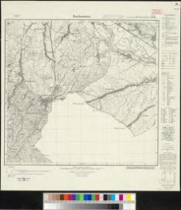
Meßtischblatt 3246 : Reichenstein, 1930
1 : 250000 Reichenstein. - Hrsg. 1883, einz. Nachtr. 1930. - 1:25000. - [Berlin]: Reichsamt für Landesaufnahme, 1930. - 1 Kt.
Weiswasser - m0077-1-005 - Kaiserpflichtexemplar der Landkarten des stabilen Katasters
1 : 2880
Weiswasser - m0077-1-001 - Kaiserpflichtexemplar der Landkarten des stabilen Katasters
1 : 2880
Weiswasser - m0077-1-004 - Kaiserpflichtexemplar der Landkarten des stabilen Katasters
1 : 2880
Weiswasser - m0077-1-002 - Kaiserpflichtexemplar der Landkarten des stabilen Katasters
1 : 2880
Weiswasser - m0077-1-006 - Kaiserpflichtexemplar der Landkarten des stabilen Katasters
1 : 2880
Weiswasser - m0077-1-003 - Kaiserpflichtexemplar der Landkarten des stabilen Katasters
1 : 2880
Ober Gostitz - m0784-1-003 - Kaiserpflichtexemplar der Landkarten des stabilen Katasters
1 : 2880
Ober Gostitz - m0784-1-005 - Kaiserpflichtexemplar der Landkarten des stabilen Katasters
1 : 2880
Ober Gostitz - m0784-1-010 - Kaiserpflichtexemplar der Landkarten des stabilen Katasters
1 : 2880
Ober Gostitz - m0784-1-009 - Kaiserpflichtexemplar der Landkarten des stabilen Katasters
1 : 2880
Ober Gostitz - m0784-1-006 - Kaiserpflichtexemplar der Landkarten des stabilen Katasters
1 : 2880
Ober Gostitz - m0784-1-007 - Kaiserpflichtexemplar der Landkarten des stabilen Katasters
1 : 2880
Ober Gostitz - m0784-1-001 - Kaiserpflichtexemplar der Landkarten des stabilen Katasters
1 : 2880
Ober Gostitz - m0784-1-002 - Kaiserpflichtexemplar der Landkarten des stabilen Katasters
1 : 2880
Ober Gostitz - m0784-1-008 - Kaiserpflichtexemplar der Landkarten des stabilen Katasters
1 : 2880
Ober Gostitz - m0784-1-004 - Kaiserpflichtexemplar der Landkarten des stabilen Katasters
1 : 2880
Kamenitz Überschaar - m1140-1-002 - Kaiserpflichtexemplar der Landkarten des stabilen Katasters
1 : 2880
Kamenitz Überschaar - m1140-1-001 - Kaiserpflichtexemplar der Landkarten des stabilen Katasters
1 : 2880
Hundorf - m0928-1-001 - Kaiserpflichtexemplar der Landkarten des stabilen Katasters
1 : 2880
Hundorf - m0928-1-002 - Kaiserpflichtexemplar der Landkarten des stabilen Katasters
1 : 2880
III. vojenské mapování 3858/1
1 : 25000
[Kartenblatt]
1 : 25000 Javorník (Jeseník, Česko : oblast) Reichsamt für Landesaufnahme
III. vojenské mapování 3858/1
1 : 25000
Weisbach (Bily Potok) - m0091-1-004 - Kaiserpflichtexemplar der Landkarten des stabilen Katasters
1 : 2880
Weisbach (Bily Potok) - m0091-1-005 - Kaiserpflichtexemplar der Landkarten des stabilen Katasters
1 : 2880
Weisbach (Bily Potok) - m0091-1-001 - Kaiserpflichtexemplar der Landkarten des stabilen Katasters
1 : 2880
Weisbach (Bily Potok) - m0091-1-007 - Kaiserpflichtexemplar der Landkarten des stabilen Katasters
1 : 2880
Weisbach (Bily Potok) - m0091-1-002 - Kaiserpflichtexemplar der Landkarten des stabilen Katasters
1 : 2880
Weisbach (Bily Potok) - m0091-1-006 - Kaiserpflichtexemplar der Landkarten des stabilen Katasters
1 : 2880