Maps of gmina Paczków

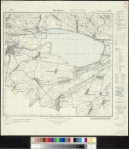
Meßtischblatt 3247 : Patschkau, 1935
1 : 250000 Patschkau. - Hrsg. 1883, einz. Nachtr. 1933, gedr. [19]35. - 1:25000. - [Berlin]: Reichsamt für Landesaufnahme, 1935. - 1 Kt.
[Kartenblatt]
1 : 25000 Bernartice (Jeseník, Česko) Reichsamt für Landesaufnahme
III. vojenské mapování 3858/1
1 : 25000
Weisbach (Bily Potok) - m0091-1-004 - Kaiserpflichtexemplar der Landkarten des stabilen Katasters
1 : 2880
Weisbach (Bily Potok) - m0091-1-005 - Kaiserpflichtexemplar der Landkarten des stabilen Katasters
1 : 2880
Weisbach (Bily Potok) - m0091-1-001 - Kaiserpflichtexemplar der Landkarten des stabilen Katasters
1 : 2880
Weisbach (Bily Potok) - m0091-1-007 - Kaiserpflichtexemplar der Landkarten des stabilen Katasters
1 : 2880
Weisbach (Bily Potok) - m0091-1-002 - Kaiserpflichtexemplar der Landkarten des stabilen Katasters
1 : 2880
Weisbach (Bily Potok) - m0091-1-006 - Kaiserpflichtexemplar der Landkarten des stabilen Katasters
1 : 2880
Weisbach (Bily Potok) - m0091-1-003 - Kaiserpflichtexemplar der Landkarten des stabilen Katasters
1 : 2880
Dorf Jauernig - m3349-1-006 - Kaiserpflichtexemplar der Landkarten des stabilen Katasters
1 : 2880
Dorf Jauernig - m3349-1-004 - Kaiserpflichtexemplar der Landkarten des stabilen Katasters
1 : 2880
Dorf Jauernig - m3349-1-005 - Kaiserpflichtexemplar der Landkarten des stabilen Katasters
1 : 2880
Dorf Jauernig - m3349-1-002 - Kaiserpflichtexemplar der Landkarten des stabilen Katasters
1 : 2880
Dorf Jauernig - m3349-1-001 - Kaiserpflichtexemplar der Landkarten des stabilen Katasters
1 : 2880
Dorf Jauernig - m3349-1-003 - Kaiserpflichtexemplar der Landkarten des stabilen Katasters
1 : 2880
Javorník
1 : 75000 Javorník (Jeseník, Česko) Vojenský zeměpisný ústav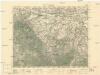
Javorník
1 : 75000 Javorník (Jeseník, Česko : oblast) Vojenský zeměpisný ústav
Cukmantl a Neustadt i. O. Schles
1 : 75000 Polsko Vojenský zeměpisný ústav
Javorník a Ottmachau
1 : 75000 Javorník (Jeseník, Česko : oblast) Vojenský zeměpisný ústav
III. vojenské mapování 3858
1 : 75000
III. vojenské mapování 3858
1 : 75000
Javorník a Ottmachau
1 : 75000 Javorník (Jeseník, Česko : oblast) Vojenský zeměpisný ústav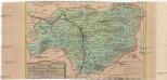
Special-Carte des Fürstenthums Grotkau oder Neisse, in Ober-Schlesien, an den böhmischen und mährische[n] Grentzen
1 : 300000 Grodków-oblast (Polsko) Wieland, Johann Wolfgang Schleuen, Johann David I.D. Schleuen
Jauernig und Weidenau.
from Spezialkarte der osterreichisch-ungarischen Monarchie.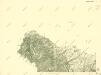
III. vojenské mapování 3858/1
1 : 25000
[Kartenblatt]
1 : 25000 Javorník (Jeseník, Česko : oblast) Reichsamt für Landesaufnahme


Barzdorf - m0055-1-002 - Kaiserpflichtexemplar der Landkarten des stabilen Katasters
1 : 2880
Barzdorf - m0055-1-001 - Kaiserpflichtexemplar der Landkarten des stabilen Katasters
1 : 2880