Maps of Krapkowice

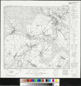
Meßtischblatt 5573 : Krappitz, 1944
1 : 250000 Krappitz. - Aufn. 1882, hrsg. 1884, bericht. 1939, Nachtr. 1942, Ausg. 1944. - 1:25000. - [Berlin]: Reichsamt für Landesaufnahme, 1944. - 1 Kt.
Cosel
1 : 75000 Ministerstvo národní obrany
Reymann ́s Special Karte 171 Neisse

171 Neisse, uit: Topographische Special-Karte von Deutschland (von Central-Europa) / begründet von D.G. Reymann ; [entworfen und gezeichn. von Heinrich Berghaus... [et al.]]
1 : 200000 Annotatie: Lit.: Daniel Gottlob Reymann und die "Topographische Special-Karte von Deutschland" / von Wolfgang Scharfe, in: Kartographische Nachrichten, 39 (1989), Heft I, p. 1-10; Handgeschreven titel: Reymann's Deutschland : 24 Sectionen: Jena, Penig, Dresden, Zittau, Hirschberg, Breslau, Brieg, Andernach, Coblenz, Giessen, Fulda, Schleusingen, Plauen, Zwickau, Teplitz, Jung Bunzlau, Hohenelbe, Glatz, Neisse, Simmern, Prag, Luxemburg, Birkenfeld; Aanwezig: 23 bladen Reymann, Daniel Gottlob; Berghaus, Heinrich [Berlin : 2. Departement des Kriegsministeriums, Bureau für Plan- und Kartenzeichnung]
146. Ratibor, uit: Topographische Uebersichtskarte des Deutschen Reiches / herausgegeben v. d. Kartogr. Abt. d. Königl. Preuß. Landesaufnahme
1 : 200000 titelvariant: Topogr. Übersichtskarte des Deutschen Reiches; Annotatie: Titel boven bladen ook: Topogr. Übersichtskarte des Deutschen Reiches; Annotatie geografische gegevens: Op elk blad twee maatstokken: 10 Kilometer = 5,5 cm; 1 geogr. Meile = 3,6 cm; Legenda onder op elk blad Königlich Preußische Landesaufnahme. Kartographische Abtheilung [S.l : Königlich Preußische Landesaufnahme, Kartographische Abtheilung]

Přehledná mapa panství biskupství Vratislavského v Československé republice podle stavu ke dni 1. ledna 1929
1 : 75000 Vratislav-oblast (Polsko) Bauer, E. Vojenský zeměpisný ústav
Das Fürstenthum Oppeln in Ober Schlesien
Mollova mapová sbírka Schleuen, Johann David Schleuen, Johann David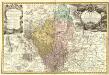
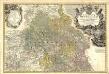
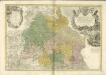
Principatvs Silesiae Grotkani exactissima Tabula geographica exhibens Terram Nissensem simul ac Circulos Grotkau Ottmuchau, et Ziegenhals.
1 : 154000 Mollova mapová sbírka Wieland, Johann Wolfgang Homann, Johann Baptista - dědici
Das Fürstenthum Oppeln in Ober Schlesien
1 : 720000 Horní Slezsko Schleuen, Johann David I.D. Schleuen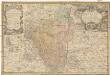
Principatvs Silesiae Grotkani exactissima tabula geographica exhibens terram Nissensem simul ac circulos Grotkau, Ottmuchau, et Ziegenhals
1 : 154000 Gródkow (Polsko) Wieland, Johann Wolfgang Schubarth, Matthäus ab Haeredibus Homannianis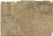
Principatvs Silesiae Grotkani exactissima tabula geographica exhibens terram Nissensem simul ac circulos Grotkau Ottmuchau, et Ziegenhals
1 : 154000 Gródkow (Polsko) Wieland, Johann Wolfgang Schubarth, Matthäus Homannianos Heredes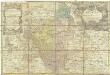
Principatvs Silesiae Grotkani exactissima tabula geographica exhibens terram Nissensem simul ac circulos Grotkau Ottmuchau, et Ziegenhals
1 : 154000 Gródkow (Polsko) Wieland, Johann Wolfgang Schubarth, Matthäus Haeredibus Homannianis
Neisse 91, uit: Special-Karte von Mittel-Europa / nach amtlichen Quellen bearbeitet von W. Liebenow
1 : 300000 titelvariant: W. Liebenow's Mittel-Europa; Annotatie: Titel boven de bladen: W. Liebenow's Mittel-Europa Johannes Wilhelm Liebenow 1822-1897 Frankfurt a. M. : Ludwig Ravenstein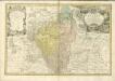

Principatvs Silesiae Oppoloniensis exactissima Tabula geographica, sistens Circvlos Oppoloniensem Ober-Glogav Gros Strehliz, Cosel, Tost, Rosenberg, Falckenberg & Lvblenitz.
1 : 216000 Mollova mapová sbírka Wieland, Johann Wolfgang Homann, Johann Baptista - dědici
Reisekarte durch die Mähr.-Schles.-Sudeten
1 : 200000 Jeseníky (Česko : pohoří) A. Blažek
Geognostische Karte von Ober-Schlesien
1 : 200000 Dolnoslezské vojvodství (Polsko) Carnall, Rudolph von Simmon Schropp & co.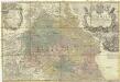
Principatvs Silesiae Oppoliensis
1 : 218000 Opolsko (Polsko) Wieland, Johann Wolfgang Homannianis Heredibus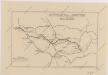
Sbírka map a diagramů použitých na mírových konferencích v Paříži v letech 1919 - 1920

Die Grafschaft Glaz in zwei Abtheilungen zum Breslauer Regierungs Bezirg gehörig
1 : 190000 Kladsko-oblast (Polsko) Schilling F.E.C. Leuckart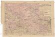
Das deutsche Sprachgebiet Nord-Mährens u. Schlesiens auf Grand der Volkszählung v. 31. Dec. 1880
1 : 300000 Morava severní (Česko) Held, Franz Wolfschütz Historisch-statistische Section der k. k. mährisch-schlesische Ackerbaugesellschaft
Mapa země Moravské. S částmi pohraničnými Slezska, Čech, Rakous i Uher

Granica Polski na Śląsku górnym
1 : 600000 Polsko Instytut kartograficzny Atlas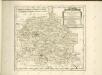
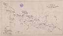
Übersichts Charte de Winterquartiere der beiden Armeen an der böhmisch-schlesischen Grenze im Winter 1760/61
1 : 600000
Kartographische Darstellung der Abstimmungs-Ergebnisse von Oberschlesien
1 : 100000 [im Auftrag des Auswärtigen Amtes bearb. in der Plankammer des Preußisch-Statistischen Landesamtes vom Gerke] ; mit Genehmigung der Landesaufnahme, Berlin Berlin : Berliner Lithographisches Institut