Maps of Jünkerath

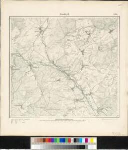
Meßtischblatt 3264 : Stadtkyll, 1895
1 : 250000 Stadtkyll. - Aufn. 1893. - 1:25000. - [Berlin]: Kgl. Preuss. Landesaufnahme, 1895. - 1 Kt.
Illustrissimo ac excellentissimo domino domino domino Ioanni Wilhelmo S. R. I. comiti in Manderscheit Blanckenknheim & Gerolstein L. B. in Iunckenrade Cronenburg, Schuller & Heistart domino in Betlingen Dhaun & Erp., archi. dioecesis coloniensis aulae praefecto haereditario, ordinis S.ti Huberti equiti, serenissimi electoris Palatini supremo legionis equestris praefecto &cc. &cc. illustrissimo ac excellentissimo domino d. Wolfgango Henrico S. R. I. comiti in Manderscheid Blanckenheim & Morhange L. B. de Hohensels & Reipolskirchen dom.m Keyll Bettingen Neuerburg Dollendorff Westhoven Brezzenheim &cc. &cc. hanc utrivsque sui comitatus Manderscheitensis tabulam geographicam
1 : 180000 Porýní-Falc (Německo) Schannat, Johann Friedrich Manderscheid-Blankenheim, Johann Wilhelm von
Geognostische Karte der vulkanischen Eifel / von E. Mitscherlich ; mit wissenschaftlicher Beihilfe von H. von Dechen
1 : 80000 Eilhard Mitscherlich 1794-1863; Heinrich von Dechen [Berlin : Roth]
137. Cochem, uit: Topographische Uebersichtskarte des Deutschen Reiches / herausgegeben v. d. Kartogr. Abt. d. Königl. Preuß. Landesaufnahme
1 : 200000 titelvariant: Topogr. Übersichtskarte des Deutschen Reiches; Annotatie: Titel boven bladen ook: Topogr. Übersichtskarte des Deutschen Reiches; Annotatie geografische gegevens: Op elk blad twee maatstokken: 10 Kilometer = 5,5 cm; 1 geogr. Meile = 3,6 cm; Legenda onder op elk blad Königlich Preußische Landesaufnahme. Kartographische Abtheilung [S.l : Königlich Preußische Landesaufnahme, Kartographische Abtheilung]
XV ; 3.M., uit: Carte chorographique des Pays-Bas Autrichiens / ... par le Comte de Ferraris ; gravée par L.A. Dupuis
1 : 86400 Annotatie: Bladen linksboven genummerd met Romeinse cijfers, rechtsboven met een cijfer en een letter; Met opdracht aan keizer Joseph II (bl.XVI); Met plattegrond van Brussel (bl. XXI), overzichtskaart (bl. XXII) en bladwijzer (bl. XXIII); Annotatie geografische gegevens: Schaalstokken: Echelle de Toises ou de Lieues communes de France; Echelle de Verges ou de Lieues de Brabant; Echelle de Milles d'Allemagne (bl. XVII); Echelle de Mètres; In de hoeken lengte- en breedtematen T.M.e en T.P.e Joseph-Jean François Ferraris Comte de 1726-1814; L.A. Dupuis [S.l. : s.n.]
XV, uit: Carte chorographique des Pays-Bas Autrichiens / ... par le Comte de Ferraris ; gravée par L.A. Dupuis
1 : 86400 Annotatie: Lit.: Les militaires et la cartographie des Pays-Bas méridionaux et de la Principauté de Liège à la fin du XVIIe et au XVIII siècle / Claire Lemoine-Isabeau. - Bruxelles, 1984, p. 206-212; La cartographie au XVIIIe siècle et l'oeuvre du Comte de Ferraris (1726-1814) : colloque international, Spa, 8-11 sept. 1976. - Bruxelles, 1978; Met opdracht aan keizer Joseph II (bl.XVI); Met plattegrond van Brussel (bl. XXI), overzichtskaart (bl. XXII) en bladwijzer (bl. XXIII); Ontbreekt: bl. I-III en XXI; Voor aanwezige bladen zie overzichtsblad Ferraris, Johann Joseph; Dupuis, L. A. [S.l. : s.n.]
[22], uit: Hydro-Oro und Chorographische General Karte des Koenigreichs der Niederlande und der angrenzenden Länder bis Paris : mit der Angabe der Kunst und Heer-Strassen und der Entfernung der Poststationen / ... zusammengetragen und reducirt von ... Wilhelm Müller
1 : 400000 titelvariant: Generalkarte des Koenigreichs Hannover; Annotatie: 1e supplement bij: Generalkarte des Koenigreichs Hannover (1818) Müller, Wilhelm (fl. 1818) [Hannover : Wilhelm Müller]
Prüm 98, uit: Special-Karte von Mittel-Europa / nach amtlichen Quellen bearbeitet von W. Liebenow
1 : 300000 titelvariant: W. Liebenow's Mittel-Europa; Annotatie: Titel boven de bladen: W. Liebenow's Mittel-Europa Johannes Wilhelm Liebenow 1822-1897 Frankfurt a. M. : Ludwig Ravenstein
Prüm 98, uit: [W. Liebenow's Special-Karte von Mittel-Europa]
1 : 300000 titelvariant: W. Liebenow's Mittel-Europa; Annotatie: Titel boven de bladen: W. Liebenow's Mittel-Europa Johannes Wilhelm Liebenow 1822-1897 Hannover : Hermann Oppermann
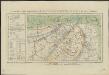
Theatre De La Guerre Dans Les Pays Qui Sont Situéz Entre le Rhin, la Saare, la Moselle et la Basse Alsace. [Karte], in: Atlas nouveau, contenant toutes les parties du monde [...], Bd. 1, S. 235.
1 Karte aus Atlas Sanson, Nicolas Jaillot, Alexis Hubert und Mortier, Pieter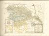

Delineatio Topographica Altissimae Atque Adeò Verae Scaturiginis Danubii Fl: Ubi monendum, tenuissimos illos ramusculos aquae à rusticis, pro irrigandis pratis ita esse excavatos; et, si hoc non foret, aquam, sine dubio, alveolo uno, aut saltem paucioribus defluxuram fuisse
1 : 6000 Mollova mapová sbírka Marsili, Luigi Ferdinando
Partie Occidentale Du Temporel De L'Archevesché et Eslectorat, De Treves. [Karte], in: Atlas nouveau, contenant toutes les parties du monde [...], Bd. 1, S. 196.
1 Karte aus Atlas Sanson, Nicolas Jaillot, Alexis Hubert und Mortier, Pieter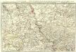
Exactissima totius Vederoviae laté sumtae Tabula
1 : 210000 Mollova mapová sbírka Buna, Wilhelm C. Broenner, Heinrich Ludwig
Le Duché de Luxembourg divisé en Quartier Walon et Allemand
1 : 140000 Mollova mapová sbírka Jaillot, Alexis-Hubert Jaillot, Alexis Hubert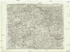
Carte topographique tres exacté de la Wetteravie
1 : 220000 Hesensko (Německo) Coentgen, Heinrich Hugo chez I.W.A. Iaeger
Carte topographique tres exacté de la Wetteravie
1 : 220000 Hesensko (Německo) Jaeger, Johann Wilhelm Abraham I. W. A. Jaeger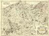
Paemani in Eburonibus
1 : 240000 Mollova mapová sbírka Sanson, Nicolas Mariette, Pierre
Höhenschichten-Karte der Eifel / von H. Rauff ; gezeichn. von W. Rose
1 : 200000 Annotatie geografische gegevens: Gebaseerd op: Topografische Uebersichtskarte des Deutschen Reiches Hermann Rauff; W. Rose fl. 1900 Bonn : Cohen

Archiepiscopatus et Electoratus Trevirensis Novissima delineatio
1 : 310000 Mollova mapová sbírka Wit, Frederik de Wit, Frederick
Treveri Archidiacne. de Coblents dans le Dioecese de l'Archevche de Treves.
Mollova mapová sbírka Sanson, Guillaume Sanson, Guillaume
Ducatus Lutzenburgici tabula
1 : 320000 Lucembursko Wit, Frederick de per Fredericum de Wit
Le Theatre de Bellone :
Mollova mapová sbírka Schenk, Pieter Braakman, Adriaan
Archiepiscopatvs Trevirensis
1 : 370000 Mollova mapová sbírka Blaeu, Willem Janszoon Blaeu, Cornelis
Archiepiscopatvs Trevirensis
1 : 370000 Mollova mapová sbírka Janssonius, Johannes Janssonius, Johannes I