Maps of Geroldsgrün

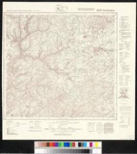
Meßtischblatt 5635 : Nordhalben, 1940
1 : 250000 Nordhalben. - Aufn. 1903/04, erkund. 1938, bericht. 1939. - 1:25000. - München, 1940. - 1 Kt.
Accurate Delineation derer Hochgraefl. Reussischen Herrschafften Lobenstein und Ebersdorff nebst der Pflege Hirschberg
1 : 83000 Schenk, Pieter P. Schenk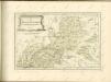

142. Plauen (bijgeschreven: Löbenstein), uit: Topographische Uebersichtskarte des Deutschen Reiches / herausgegeben v. d. Kartogr. Abt. d. Königl. Preuß. Landesaufnahme
1 : 200000 titelvariant: Topogr. Übersichtskarte des Deutschen Reiches; Annotatie: Titel boven bladen ook: Topogr. Übersichtskarte des Deutschen Reiches; Annotatie geografische gegevens: Op elk blad twee maatstokken: 10 Kilometer = 5,5 cm; 1 geogr. Meile = 3,6 cm; Legenda onder op elk blad Königlich Preußische Landesaufnahme. Kartographische Abtheilung [S.l : Königlich Preußische Landesaufnahme, Kartographische Abtheilung]
Delineatio geographica specialis territorii celsissimorum S. R. I. comitum Ruthenorum de Plauia utriusque linea senioris et iunioris partem Vogtlandiae
1 : 150000 Greiz (Německo) Schulz, Johann Gottlieb Lotter, Georg F. Tob. Conrado Lotter
Delineatio geographica specialis territorii celsissimorum S.R.I. comitum Ruthenorum de Plauia utriusque linea senioris et iunioris partem Vogtlandiae
1 : 150000 Greiz (Německo) Schulz, Johann Gottlieb Lotter, Georg F. Tob. Conrado Lotter
Bamberg 101, uit: Special-Karte von Mittel-Europa / nach amtlichen Quellen bearbeitet von W. Liebenow
1 : 300000 titelvariant: W. Liebenow's Mittel-Europa; Annotatie: Titel boven de bladen: W. Liebenow's Mittel-Europa Johannes Wilhelm Liebenow 1822-1897 Frankfurt a. M. : Ludwig Ravenstein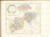

Terra Advocatorvm Vulgo Voightland
1 : 290000 Mollova mapová sbírka Örnehufvud, Olof Hansson Blaeu, Joan I.
Coburg
1 : 300000 R. Mittelbach
Tabulae Marchionatus Brandenburgico-Culmbacensis sive Baruthini Pars Superior cum adjacentibus Regionibus exhibita
1 : 180000 Mollova mapová sbírka Riediger, Johann Adam Seutter, Matthäus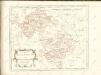

Tabulae principatus Brandenburgico-Culmbacensis sive Baruthini
1 : 225600 Bavorsko severní (Německo) Riediger, Johann Adam Lotter, Tobias Conrad I.A. Riediger
Terra Advocatorvm vulgo Voightland
1 : 290000 Vogtland (Německo) Örnehufvud, Olof Hansson Blaeu, Joan J. Blaeu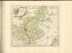

TERRA ADVOCATORVM | Vulgo | VOIGHTLAND
Descripta ab Olao Ioannis Gotho | S.R.M. Sueciæ Geographo. Amstelædami | J. Blaeu excudebat.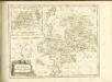

Carte topographique d'Allemagne contenant une partie du royaume de Boheme, une partie de la Saxe
1 Karte : Kupferdruck ; 46 x 61 cm Jaeger; Hauer se vend chez I. W. A. Iaeger
Sac. Rom. Imperii Principatus & Episcopatus Bambergensis Nova Tabula Geographica
1 : 260000 Mollova mapová sbírka Homann, Johann Baptist Homann, Johann Baptista
Zu den Operationen der Generale Syburg, Schenkendorf und Linden gegen die Reichsarmee, vom 15ten Februar bis zum 5ten April 1761

Karte des Thüringer-Wald-Gebirges zugleich special Karte des Herzogthums Sachs-Meiningen-Hildburghausen des Fürstenthums Coburg und der Schwarzburgischen Fürstenthümer Rudolstadt und Sondershausen
Grosser Hand-Atlas über alle Theile der Erde in 170 Karten Meyer, J. Verlag des Bibliographischen Instituts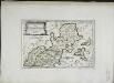
Des Bisthums Bamberg nördliche Aemter
1 Karte : Kupferdruck ; 19 x 29 cm Reilly F. J. J. von Reilly
Thuringer-Wald-Gebirges.
1 : 380000 Grassl, J. (Joseph)
Sac. Rom. Imperii principatus & episcopatus Bambergensis nova tabula geographica
1 : 215000 Bamberg-oblast (Německo) Homann, Johann Baptist á Io. Bapt. Homanno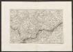
Militair Karte von Süd-Deutschland in 20 Sectionen
1 : 400000 3. Section Coulon, Alois von A. von Coulon
Geographische Charte
1 : 300000 Mollova mapová sbírka Zollmann, Friedrich
Herzogtum Sachsen-Meiningen 1829 Verwaltungsstruktur
Sachsen-Meiningen Verwaltung Kunz, Andreas ; Moeschl, Joachim Robert
Herzogtum Sachsen-Meiningen 1826 Verwaltungsstruktur
Sachsen-Meiningen Verwaltung Kunz, Andreas ; Moeschl, Joachim Robert
Sac. Rom. Imperii principatus [et] episcopatus Bambergensis nova tabula geographica
1 Karte : Kupferdruck ; 47 x 56 cm Homann Johann Baptist Homann