Maps of Adorf/Vogtland

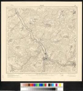
Meßtischblatt 5639 : Adorf, 1942
1 : 250000 Adorf. - Umdr.-Ausg., aufgen. 1908, hrsg. 1913, bericht. - 1:25000. - Leipzig, 1942. - 1 Kt.
Meßtischblatt 151 : Adorf, 1929
1 : 250000 Adorf. - Umdr.-Ausg., aufgen. 1908, hrsg. 1913, bericht. 1920, einz. Nachtr. 1928. - 1:25000. - Leipzig, 1929. - 1 Kt.
Meßtischblatt 151 : Adorf, 1920
1 : 250000 Adorf. - Aufgen. 1908, hrsg. 1913, bericht. 1920. - 1:25000. - Leipzig, 1920. - 1 Kt.
[Kartenblatt]
1 : 25000 Doubrava (Aš, Česko) Reichsamt für Landesaufnahme
Rossbach - c2332-2-005 - Kaiserpflichtexemplar der Landkarten des stabilen Katasters
1 : 2880
Rossbach - c2332-2-006 - Kaiserpflichtexemplar der Landkarten des stabilen Katasters
1 : 2880
Rossbach - c2332-2-003 - Kaiserpflichtexemplar der Landkarten des stabilen Katasters
1 : 2880
Rossbach - c2332-2-001 - Kaiserpflichtexemplar der Landkarten des stabilen Katasters
1 : 2880
Rossbach - c2332-2-004 - Kaiserpflichtexemplar der Landkarten des stabilen Katasters
1 : 2880
Rossbach - c2332-2-002 - Kaiserpflichtexemplar der Landkarten des stabilen Katasters
1 : 2880
Podrobná mapa Království českého
1 : 100000 Hranice (Cheb, Česko : oblast) Srp, Jan Jos. R. Vilímek
Vilímkovy místopisné mapy zemí Koruny české
1 : 100000 Hranice (Cheb, Česko : oblast) Srp, Jan Jos. R. Vilímek
Rossbach
1 : 75000 Aš (Česko : oblast) Vojenský zeměpisný ústav
Rossabch in Böhmen und Oelsnitz in Sachsen
1 : 75000 Cheb (Česko : oblast) Maschka K. u. k. militär-geographisches Institut
Rossabch in Böhmen und Oelsnitz in Sachsen
1 : 75000 Cheb (Česko : oblast) Maschka K. u. k. Militärgeographisches Institut
Rossbach in Böhmen und Oelsnitz in Sachsen
1 : 75000 Hranice-oblast (Cheb, Česko) K. u. k. Militärgeographisches Institut
Umgebungen von Neudek
Nejdek-oblast (Karlovy Vary, Česko) Kiss, Josef K. u. k. Militärgeographisches Institut
Rossbach in Bohmen und Oelsnitz (Im Sachsen).
from Spezialkarte der osterreichisch-ungarischen Monarchie.

III. vojenské mapování 3848
1 : 75000
Landcharte über die Reichs Adel Zedwizische und der Cron Boeheim zulehen Rührende Herschaft und gütter zu Ascha welche von folgenden possediret werden
Aš-oblast (Česko) Bauer, Joannes Assner, L.
Soubor přehledných map pro plánování a statistiku: 3848 – Hranice

III. vojenské mapování 3848/4
1 : 25000
III. vojenské mapování 3848/4
1 : 25000
Generalkarte der Bezirkshauptmannschaft Asch
1 : 220000 Aš (Česko) Wagner, Jan Eduard F. Kytka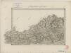
II. vojenské mapování 5
1 : 144000
Der Voigtlaendische Kreis
1 : 50000 Sasko (Německo) Riedig, Christian G. Leutenan, H. Schreibers Erben
Die Umgebungen von Carlsbad und Eger als Orientierungskarte für Kurgäste
Cheb-oblast (Česko) Zimmer Franz Zimmer und Sohn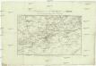
Die Umgebungen von Carlsbad und Eger als Orientierungskarte für Kurgäste
Cheb-oblast (Česko) bey Franz Zimmer und Sohn, Kunst, Kunsthaendlern