Maps of Gorzanów

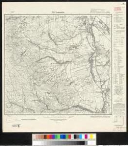
Meßtischblatt 3295 : Alt Lomnitz, 1936
1 : 250000 Alt Lomnitz. - Hrsg. 1884, bericht. 1919, gedr. [19]36. - 1:25000. - [Berlin]: Reichsamt für Landesaufnahme, 1936. - 1 Kt.
Meßtischblatt 3295 : Alt- Lomnitz, 1884
1 : 250000 Alt- Lomnitz. - Aufn. 1882. - 1:25000. - [Berlin]: Kgl. Preuss. Landesaufnahme, 1884. - 1 Kt.
Kronstadt a. d. Wilden Adler
1 : 75000 Kladsko (Polsko : oblast) Brunner K. u. k. militär-geographisches Institut
Kronstadt a. d. Wilden Adler
1 : 75000 Kladsko (Polsko : oblast) Brunner K. u. k. militär-geographisches Institut
Kronstadt a. d. Wilden Adler
1 : 75000 Kladsko (Polsko : oblast) Brunner K. u. k. Militärgeographisches Institut
Kronstadt a. d. Wilden Adler
1 : 75000 Čechy (Česko) K. u. k. Militärgeographisches Institut
Kronstadt a.d. Wilden Adler.; Spezialkarte der osterreichisch-ungarischen Monarchie.
from Spezialkarte der osterreichisch-ungarischen Monarchie. Austro-Hungarian Monarchy. Militärgeographisches Institut.,

III. vojenské mapování 3857
1 : 75000
Glatz
1 : 100000 Kladsko-oblast (Polsko) Petters, H.
Kunštát a Glatz
1 : 75000 Kladsko (Polsko : oblast) Vojenský zeměpisný ústav
Das Adlergebirge
Orlické hory (Česko a Polsko) Deutscher Gebirgsverein für das Adlergebirge
Orlické hory s podhůřím

Orlické hory s podhůřím
1 : 75000 Orlické hory (Česko a Polsko : oblast) Mach, Adolf A. Mach
[Kartenblatt]
1 : 25000 Bystřické hory (Polsko) Reichsamt für Landesaufnahme
Podrobná mapa Markrabství moravského a Vévodství slezkého
1 : 100000 Javorník (Jeseník, Česko : oblast) Srp, Jan Jos. R. Vilímek
[Kartenblatt]
1 : 25000 Broumov (Náchod, Česko : oblast) Reichsamt für Landesaufnahme
III. vojenské mapování 3857/1-3
1 : 25000
Orlické hory

Blatt VII, uit: Geologisch-hydrographische Beschreibung des Niederschlagsgebietes der Glatzer-Neisse (oberhalb der Steinemündung) / A. Leppla ; hrsg. von der Königl. Preussischen geologischen Landesanstalt u. Bergakademie
Annotatie: Omslagtitel Königl. Preussische geologische Landesanstalt u. Bergakademie Berlin : Schropp
Orlické hory
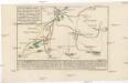
Plan des Angriffs, welcher unter dem ober Comando des kays. könig. Herrn Feldmarschall Lieutenants Grafen v. Wurmser, auf Habelschwerd, u. dem Blokhaus zu Oberschwedeldorffen in der Grafschafft Glaz den 18 Ien[n]er 1779 glücklich vollzogen worden
Kladská Bystřice (Polsko) Marinville, de Will, Johann Martin Ioh. Martin Will
Blatt I, uit: Geologisch-hydrographische Beschreibung des Niederschlagsgebietes der Glatzer-Neisse (oberhalb der Steinemündung) / A. Leppla ; hrsg. von der Königl. Preussischen geologischen Landesanstalt u. Bergakademie
Annotatie: Omslagtitel Königl. Preussische geologische Landesanstalt u. Bergakademie Berlin : Schropp
Orlické hory

Orlické hory

Die Grafschaft Glatz
1 : 460000 Kladsko (Polsko : oblast) Schreiber, Johann Georg J.G. Schreibern
Orlické hory
1 : 100000 Orlické hory-oblast (Česko a Polsko) Pták, J. Kratěna, J. nákladem odboru K. Čs. T.
145. Glatz, uit: Topographische Uebersichtskarte des Deutschen Reiches / herausgegeben v. d. Kartogr. Abt. d. Königl. Preuß. Landesaufnahme
1 : 200000 titelvariant: Topogr. Übersichtskarte des Deutschen Reiches; Annotatie: Titel boven bladen ook: Topogr. Übersichtskarte des Deutschen Reiches; Annotatie geografische gegevens: Op elk blad twee maatstokken: 10 Kilometer = 5,5 cm; 1 geogr. Meile = 3,6 cm; Legenda onder op elk blad Königlich Preußische Landesaufnahme. Kartographische Abtheilung [S.l : Königlich Preußische Landesaufnahme, Kartographische Abtheilung]
Die souveraine Graffschaft Glatz an der Schlesischen Gräntze
Kladsko-oblast (Polsko) Schleuen, Johann David I.D. Schleuen