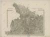
Maps of Bodzanów

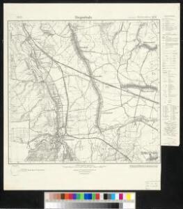
Meßtischblatt 5670 : Ziegenhals, 1936
1 : 250000 Ziegenhals. - Hrsg. 1885, einz. Nachtr. 1930, gedr. [19]36. - 1:25000. - [Berlin]: Reichsamt für Landesaufnahme, 1936. - 1 Kt.
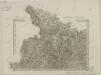
Meßtischblatt 3300 : Ziegenhals, 1912
1 : 250000 Ziegenhals. - Aufn. 1883, hrsg. 1885, Nachtr. [19]12. - 1:25000. - [Berlin]: Kgl. Preuss. Landesaufnahme, 1912. - 1 Kt.
[Kartenblatt]
1 : 25000 Morava (Česko) Reichsamt für Landesaufnahme
Kohlsdorf (Uhelna) - m1246-1-002 - Kaiserpflichtexemplar der Landkarten des stabilen Katasters
1 : 2880
Kohlsdorf (Uhelna) - m1246-1-003 - Kaiserpflichtexemplar der Landkarten des stabilen Katasters
1 : 2880
Kohlsdorf (Uhelna) - m1246-1-001 - Kaiserpflichtexemplar der Landkarten des stabilen Katasters
1 : 2880
Hotzenplotz und Zuckmantel
1 : 75000 Morava (Česko) Radler K. u. k. Militärgeographisches Institut
III. vojenské mapování 3859
1 : 75000
III. vojenské mapování 3859
1 : 75000
Podrobná mapa Markrabství moravského a Vévodství slezkého
1 : 100000 Moravské markrabství Srp, Jan Jos. R. Vilímek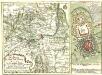
Die Gegend der Stadt und Vestung Neyss Im Herzogthum Schlesien samt denen befindlichen Orthschaften von Drey Meilen im Umcreyß
Mollova mapová sbírka Lidl, Johann Jacob
Hotzenplotz und Zuckmantel.
from Spezialkarte der osterreichisch-ungarischen Monarchie.

III. vojenské mapování 3859/3
1 : 25000
Niklasdorf - m1786-1-003 - Kaiserpflichtexemplar der Landkarten des stabilen Katasters
1 : 2880
Niklasdorf - m1786-1-009 - Kaiserpflichtexemplar der Landkarten des stabilen Katasters
1 : 2880
Niklasdorf - m1786-1-006 - Kaiserpflichtexemplar der Landkarten des stabilen Katasters
1 : 2880
Niklasdorf - m1786-1-007 - Kaiserpflichtexemplar der Landkarten des stabilen Katasters
1 : 2880
Niklasdorf - m1786-1-005 - Kaiserpflichtexemplar der Landkarten des stabilen Katasters
1 : 2880
Niklasdorf - m1786-1-001 - Kaiserpflichtexemplar der Landkarten des stabilen Katasters
1 : 2880
Niklasdorf - m1786-1-008 - Kaiserpflichtexemplar der Landkarten des stabilen Katasters
1 : 2880
Niklasdorf - m1786-1-002 - Kaiserpflichtexemplar der Landkarten des stabilen Katasters
1 : 2880
Niklasdorf - m1786-1-010 - Kaiserpflichtexemplar der Landkarten des stabilen Katasters
1 : 2880
Niklasdorf - m1786-1-004 - Kaiserpflichtexemplar der Landkarten des stabilen Katasters
1 : 2880
Umgebungen von Friedberg und Freywaldau
Jeseník-oblast (Česko)
II. vojenské mapování - speciální mapa Markrabství moravského s částí Slezského vévodství 1
1 : 144000
Umgebungen von Friedberg und Freywaldau
1 : 144000 K.K. Militärisches Geographisches Institut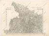
Special - Karte der Markgrafschaft Maehren und des Herzogthums Schlesien
II. vojenské mapování 1
1 : 144000