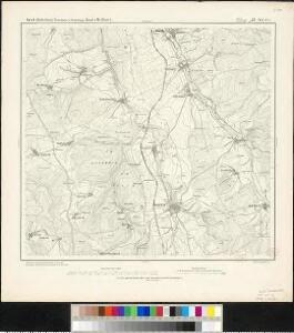
Maps of Hünstetten

Meßtischblatt 35 : Idstein, 1876
1 : 250000 Idstein. - Aufn. 1867. - 1:25000. - [Berlin]: Kgl. Min. f. Handel, 1876. - 1 Kt.
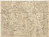
Le Flambeau de la Guerre Allumee au Rhin
Mollova mapová sbírka Delisle, Guillaume Schenk, Peter II
Nova et Accurata Moguntini Archiepiscopatus delineatio
1 : 620000 Mollova mapová sbírka Janssonius, Johannes Janssonius, Johannes I
Strategische Situation am: 26. Juni, 4. Juli (Abends), 10. Juli (9 Uhr Morgens), 14. Juli Machmittags nach dem Gefecht von Aschaffenburg, 21. Juli, 26. Juli (Morges)
Hesensko (Německo)
138. Coblenz, uit: Topographische Uebersichtskarte des Deutschen Reiches / herausgegeben v. d. Kartogr. Abt. d. Königl. Preuß. Landesaufnahme
1 : 200000 titelvariant: Topogr. Übersichtskarte des Deutschen Reiches; Annotatie: Titel boven bladen ook: Topogr. Übersichtskarte des Deutschen Reiches; Annotatie geografische gegevens: Op elk blad twee maatstokken: 10 Kilometer = 5,5 cm; 1 geogr. Meile = 3,6 cm; Legenda onder op elk blad Königlich Preußische Landesaufnahme. Kartographische Abtheilung [S.l : Königlich Preußische Landesaufnahme, Kartographische Abtheilung]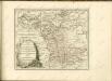

Partie Septentrionalo Des Pays qui sont Situéz Entre le Rhein la Saare, la Moselle, et la Basse Alsace
1 : 150000 Mollova mapová sbírka Mortier, Pieter Covens, Johannes I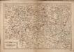
Les Environs De La Lahne depuis Marbvrg iusqu' à Ems avec les pais adiacents
1 : 200000
Nassovia Principatus
1 : 170000 Mollova mapová sbírka Stetter, Johann Jakob Schenk, Peter II
Wetteravia
1 : 210000 Mollova mapová sbírka Valk, Gerhard Schenk, Peter I
Pars Vederoviae plvrimas ditiones princ. et com. Nassovicor. imprimis verô regionem Schwalbacensem acidulis claram exhibens accurate distincta
Hesensko (Německo) Homann, Johann Baptist J. B. Homann
Pars Vederoviae Plurimas Ditiones Princ. et Com. Nassovicor. imprimis verô Regionem Schwalbacensem Acidulis claram
1 : 170000 Mollova mapová sbírka Homann, Johann Baptist Homann, Johann Baptista
Mappa geographica exhibens principatum Nassoviae
1 : 172000 Nasavsko Lotter, Tobias Conrad Lotter, Georg F. sumptibus et curis Tobiae Conradi Lotter
Nassovia principatus, cum omnibus ei pertinentibus comitatibus dominiiis, ac praefecturis, ut et confiniis intrá Lahnum, Rhenum et Moenum flumina
1 : 1500000 ad situm verum exacte delineatus â Joh. Jac. Stetter [...] excudit Nic. Visscheri vidua Amstelodami : nunc apud Petrum Schenk Iunior
Partie Orientale du Temporel, de l'Archevesché et Eslectorat de Treves
1 : 220000 Mollova mapová sbírka Sanson, Guillaume Jaillot, Alexis Hubert
Wetteravia die Wetteraw.
1 : 210000 Walther, Johann Georg Walther
Partie Occidentale du Temporel de l'Archevesché et Eslectorat de Mayence et le Haut et Bas Comté de Catzenellenboge
1 : 250000 Mollova mapová sbírka Sanson, Guillaume Jaillot, Alexis Hubert
Partie Occidentale du Temporel de l'Archevesché et Eslectorat de Mayence et le Haut et Bas Comté de Catzenellenboge
1 : 250000 Mollova mapová sbírka Sanson, Guillaume Jaillot, Alexis Hubert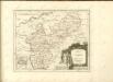

Frankfurt 99, uit: [W. Liebenow's Special-Karte von Mittel-Europa]
1 : 300000 titelvariant: W. Liebenow's Mittel-Europa; Annotatie: Titel boven de bladen: W. Liebenow's Mittel-Europa Johannes Wilhelm Liebenow 1822-1897 Hannover : Hermann Oppermann
Wetteravia. die Wetteraw. [Karte], in: Novus atlas absolutissimus, Bd. 2, S. 186.
1 Karte aus Atlas Janssonius Offizin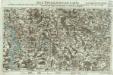
Neue Topographische Carte Der Lahn von Marburg bis zu ihrem Einflus in den Rhein mit Bemerkung der in dieser Gegend vorgefallenen Kriegsbegebenheiten von 1795 und 1796
Brand, Peter; Thum, C.; Schalck, Anna Maria; Coentgen, Georg Joseph Brand u. Thum
Pars Occidentalis Temporalis Archiepiscopatvs, et Electoratvs Mogvntinensis, nec non Superioris et inferioris Comitatus Cattimellebogensis
1 : 210000 Mollova mapová sbírka Walther, Johann Georg Hailler, Martin Walther, Johann Georg
Frankfurt a.M. 99, uit: Special-Karte von Mittel-Europa / nach amtlichen Quellen bearbeitet von W. Liebenow
1 : 300000 titelvariant: W. Liebenow's Mittel-Europa; Annotatie: Titel boven de bladen: W. Liebenow's Mittel-Europa Johannes Wilhelm Liebenow 1822-1897 Frankfurt a. M. : Ludwig Ravenstein
Partie Orientale Du Temporel De L'Archevesché et Eslectorat, De Treves
1 : 210000 Mollova mapová sbírka Sanson, Guillaume Jaillot, Alexis Hubert
Nassau, Hessen-Homburg, Frankfurt.
1 : 344000 Flemming, Carl
Das Herzogthum Nassau
1 : 200000 Wimmer, Friedrich Scholz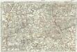
Tractus Hunnorum tabula exactissima, proponens maximam partem Sylvae olim dictae Arduenna, elect. Mogunt. Palat. ad Rhenum, et Trevir. princip. et com. Cattimelib. infer. Nassov. cum adjac. comit. et regionibus intra Rhenum, Mosellam, Saramque, secundum exactissimae vederoviae
Ardeny Buna, Wilhelm C.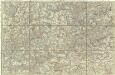
[Poříčí Mosely]
Mosela, řeka-oblast Buna, Wilhelm C.