Maps of Halsenbach

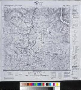
Meßtischblatt 5811 : Kestert, 1947
1 : 250000 Kestert. - Aufn. 1901, hrsg. 1903, bericht. 1935, letzte Na. - 1:25000. - Bad Godesberg: HVA, 1947. - 1 Kt.
Situation von der Vestung Rheinfels
Hill, Johann Jakob
Le Flambeau de la Guerre Allumee au Rhin
Mollova mapová sbírka Delisle, Guillaume Schenk, Peter II
Carte geographique du Comte Inferievr de Cazenelnbogen, mise au jour par les Heritiers de Homann. Avec Pr. Imperial. l'An. 1745
1 : 75000 Mollova mapová sbírka Homann, Johann Baptist Homann, Johann Baptista - dědici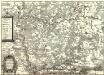
Die Nider Graffschafft Catzenellenbogen Sampt dero angrentzende Länder
1 : 80000 Mollova mapová sbírka Person, Nikolaus Person, Nicolas
Inferioris Comitatvs Cattimelibocensis delineatio geographica una cum confiniis
1 : 75000 Homann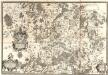
Dioecesis Trevirensis Tractvs Mosellanvs Inferior
1 : 50000 Mollova mapová sbírka Person, Nikolaus Person, Nicolas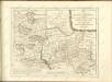

138. Coblenz, uit: Topographische Uebersichtskarte des Deutschen Reiches / herausgegeben v. d. Kartogr. Abt. d. Königl. Preuß. Landesaufnahme
1 : 200000 titelvariant: Topogr. Übersichtskarte des Deutschen Reiches; Annotatie: Titel boven bladen ook: Topogr. Übersichtskarte des Deutschen Reiches; Annotatie geografische gegevens: Op elk blad twee maatstokken: 10 Kilometer = 5,5 cm; 1 geogr. Meile = 3,6 cm; Legenda onder op elk blad Königlich Preußische Landesaufnahme. Kartographische Abtheilung [S.l : Königlich Preußische Landesaufnahme, Kartographische Abtheilung]
Nova et Accurata Moguntini Archiepiscopatus delineatio
1 : 620000 Mollova mapová sbírka Janssonius, Johannes Janssonius, Johannes I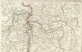
Carte Particuliere de Pays qui sont situéz entre le Rhein, la Saare, la Moselle, et la Basse Alsace
1 : 150000 Mollova mapová sbírka Jaillot, Alexis-Hubert Jaillot, Alexis Hubert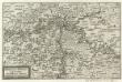
Mosella et Rheni Confluxus
Mollova mapová sbírka Person, Nikolaus Person, Nicolas
Nassoviae Principatus et ad cum spectantes Ditiones
1 : 180000 Mollova mapová sbírka Seutter, Matthäus Seutter, Matthäus
Delineatio Geographica generalis comprehendens VI. Foliis Singulos Principatvs Comitatvs Ditiones Dynastias omnes quotquot Imperio Serenissimi Principis Landgrafii Hasso-Darmstadiensis subsunt :
1 : 180000 Mollova mapová sbírka Bronner, Christian Maximilian Homann, Johann Baptista - dědici
Mosellauf von Koblenz bis Trier : mit seitlich angebrachtem Führer
Annotatie: Op omslag: Nr. 28 Da; Met beschrijving van bezienswaardigheden aan weerszijden van de kaart Köln : Bremer
Partie Orientale du Temporel, de l'Archevesché et Eslectorat de Treves
1 : 220000 Mollova mapová sbírka Sanson, Guillaume Jaillot, Alexis Hubert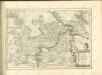
Neue Topographische Carte Der Lahn von Marburg bis zu ihrem Einflus in den Rhein mit Bemerkung der in dieser Gegend vorgefallenen Kriegsbegebenheiten von 1795 und 1796
Brand, Peter; Thum, C.; Schalck, Anna Maria; Coentgen, Georg Joseph Brand u. Thum
Partie Orientale Du Temporel De L'Archevesché et Eslectorat, De Treves
1 : 210000 Mollova mapová sbírka Sanson, Guillaume Jaillot, Alexis Hubert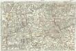
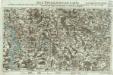
Tractus Hunnorum tabula exactissima, proponens maximam partem Sylvae olim dictae Arduenna, elect. Mogunt. Palat. ad Rhenum, et Trevir. princip. et com. Cattimelib. infer. Nassov. cum adjac. comit. et regionibus intra Rhenum, Mosellam, Saramque, secundum exactissimae vederoviae
Ardeny Buna, Wilhelm C.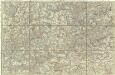
[Poříčí Mosely]
Mosela, řeka-oblast Buna, Wilhelm C.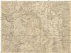
Kriegs Theater der teutschen und franzoesischen Graenz Landen zwischen dem Rhein und der Mosel, im Jahr 1794
1 : 90000 Mosel (Německo) Dewarat, Peter Leizel, Balthasar Friedrich I.L.C. Rheinwald
Nassovia Comitatvs
1 : 1300000 Mollova mapová sbírka Hondius, Henricus Hondius, Henricus
Partie Septentrionalo Des Pays qui sont situéz Entre le Rhein, la Saare, la Moselle, et la Basse Alsace. [Karte], in: Atlas nouveau, contenant toutes les parties du monde [...], Bd. 1, S. 238.
1 Karte aus Atlas Sanson, Nicolas Jaillot, Alexis Hubert und Mortier, Pieter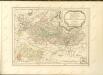

Charte vom Herzogthum Nassau
1 : 200000 Fembo, Christoph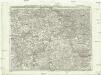
Carte topographique tres exacté de la Wetteravie
1 : 220000 Hesensko (Německo) Coentgen, Heinrich Hugo chez I.W.A. Iaeger
Carte topographique tres exacté de la Wetteravie
1 : 220000 Hesensko (Německo) Jaeger, Johann Wilhelm Abraham I. W. A. Jaeger
[Kaart], uit: Relief-Panorama des Rheines
titelvariant: Rhein Panorama von Mainz bis Köln; Annotatie: Omslagtitel: Rhein Panorama von Mainz bis Köln Köln-Ehrenfeld : Hoursch & Bechstedt