Maps of Sankt Goarshausen

Meßtischblatt 5812 : St. Goarshausen, 1941
1 : 250000 St. Goarshausen. - Aufn. 1901, hrsg. 1903, bericht. 1935, letzte Nachtr. 1940, Ausg. 1941, Nur für d. Dienstgebrauch!. - 1:25000. - [Berlin]: Reichsamt für Landesaufnahme, 1941. - 1 Kt.
Meßtischblatt 3366 : St. Goarshausen, 1917
1 : 250000 St. Goarshausen. - Aufn. 1901, hrsg. 1903, Auflagendr. 1917, B[ericht. 19]05. N[achtr. 19]14. - 1:25000. - [Berlin]: Kgl. Preuss. Landesaufnahme, 1917. - 1 Kt.
Meßtischblatt 38a / 38b : Nied. Kestert / St. Goarshausen, 1878
1 : 250000 Nied. Kestert / St. Goarshausen. - [Aufn. 1878]. - 1:25000. - [Berlin]: Kgl. Min. f. Handel, 1878. - 1 Kt.
Plan der Vestung Rhein-Fels
Hill, Johann Jakob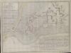
Plan von der Vestung Rheinfels
Hill, Johann Jakob
Situation von der Vestung Rheinfels
Hill, Johann Jakob
Le Flambeau de la Guerre Allumee au Rhin
Mollova mapová sbírka Delisle, Guillaume Schenk, Peter II
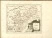
Carte geographique du Comte Inferievr de Cazenelnbogen, mise au jour par les Heritiers de Homann. Avec Pr. Imperial. l'An. 1745
1 : 75000 Mollova mapová sbírka Homann, Johann Baptist Homann, Johann Baptista - dědici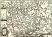
Die Nider Graffschafft Catzenellenbogen Sampt dero angrentzende Länder
1 : 80000 Mollova mapová sbírka Person, Nikolaus Person, Nicolas
Inferioris Comitatvs Cattimelibocensis delineatio geographica una cum confiniis
1 : 75000 Homann
Nova et Accurata Moguntini Archiepiscopatus delineatio
1 : 620000 Mollova mapová sbírka Janssonius, Johannes Janssonius, Johannes I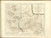

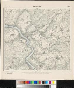
138. Coblenz, uit: Topographische Uebersichtskarte des Deutschen Reiches / herausgegeben v. d. Kartogr. Abt. d. Königl. Preuß. Landesaufnahme
1 : 200000 titelvariant: Topogr. Übersichtskarte des Deutschen Reiches; Annotatie: Titel boven bladen ook: Topogr. Übersichtskarte des Deutschen Reiches; Annotatie geografische gegevens: Op elk blad twee maatstokken: 10 Kilometer = 5,5 cm; 1 geogr. Meile = 3,6 cm; Legenda onder op elk blad Königlich Preußische Landesaufnahme. Kartographische Abtheilung [S.l : Königlich Preußische Landesaufnahme, Kartographische Abtheilung]
Section Mainz, uit: Charte von dem Grossherzogtum Hessen und dem Herzogtum Nassau / trigonometrisch aufgenommen und hrsg. von C.L.P. Eckhardt
1 : 200000 titelvariant: Karte von Hessen und Nassau Eckhardt, C. L. P Darmstadt : Joh. Wilh. Heyer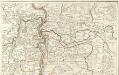
Carte Particuliere de Pays qui sont situéz entre le Rhein, la Saare, la Moselle, et la Basse Alsace
1 : 150000 Mollova mapová sbírka Jaillot, Alexis-Hubert Jaillot, Alexis Hubert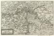
Mosella et Rheni Confluxus
Mollova mapová sbírka Person, Nikolaus Person, Nicolas
Partie Septentrionalo Des Pays qui sont Situéz Entre le Rhein la Saare, la Moselle, et la Basse Alsace
1 : 150000 Mollova mapová sbírka Mortier, Pieter Covens, Johannes I
Nassovia Principatus
1 : 170000 Mollova mapová sbírka Stetter, Johann Jakob Schenk, Peter II
Pars Vederoviae plvrimas ditiones princ. et com. Nassovicor. imprimis verô regionem Schwalbacensem acidulis claram exhibens accurate distincta
Hesensko (Německo) Homann, Johann Baptist J. B. Homann
Pars Vederoviae Plurimas Ditiones Princ. et Com. Nassovicor. imprimis verô Regionem Schwalbacensem Acidulis claram
1 : 170000 Mollova mapová sbírka Homann, Johann Baptist Homann, Johann Baptista
Nassoviae Principatus et ad cum spectantes Ditiones
1 : 180000 Mollova mapová sbírka Seutter, Matthäus Seutter, Matthäus
Mappa geographica exhibens principatum Nassoviae
1 : 172000 Nasavsko Lotter, Tobias Conrad Lotter, Georg F. sumptibus et curis Tobiae Conradi Lotter
Delineatio Geographica generalis comprehendens VI. Foliis Singulos Principatvs Comitatvs Ditiones Dynastias omnes quotquot Imperio Serenissimi Principis Landgrafii Hasso-Darmstadiensis subsunt :
1 : 180000 Mollova mapová sbírka Bronner, Christian Maximilian Homann, Johann Baptista - dědici
Nassovia principatus, cum omnibus ei pertinentibus comitatibus dominiiis, ac praefecturis, ut et confiniis intrá Lahnum, Rhenum et Moenum flumina
1 : 1500000 ad situm verum exacte delineatus â Joh. Jac. Stetter [...] excudit Nic. Visscheri vidua Amstelodami : nunc apud Petrum Schenk Iunior
Mosellauf von Koblenz bis Trier : mit seitlich angebrachtem Führer
Annotatie: Op omslag: Nr. 28 Da; Met beschrijving van bezienswaardigheden aan weerszijden van de kaart Köln : Bremer
Partie Orientale du Temporel, de l'Archevesché et Eslectorat de Treves
1 : 220000 Mollova mapová sbírka Sanson, Guillaume Jaillot, Alexis Hubert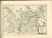

Partie Occidentale du Temporel de l'Archevesché et Eslectorat de Mayence et le Haut et Bas Comté de Catzenellenboge
1 : 250000 Mollova mapová sbírka Sanson, Guillaume Jaillot, Alexis Hubert
Partie Occidentale du Temporel de l'Archevesché et Eslectorat de Mayence et le Haut et Bas Comté de Catzenellenboge
1 : 250000 Mollova mapová sbírka Sanson, Guillaume Jaillot, Alexis Hubert