Maps of gmina Krzanowice

Meßtischblatt 3417 : Katscher, 1938
1 : 250000 Katscher. - Hrsg. 1883, bericht. 1928, red. Änd. [19]38. - 1:25000. - [Berlin]: Reichsamt für Landesaufnahme, 1938. - 1 Kt.
[Kartenblatt]
1 : 25000 Kietrz (Polsko) Reichsamt für Landesaufnahme
[Kartenblatt]
1 : 25000 Morava (Česko) Reichsamt für Landesaufnahme
III. vojenské mapování 3960
1 : 75000
Carte ethnographique de la partie de la Haute-Silésie cedée a l'etat Tchécoslovaque par le traité de Versailles
1 : 125000 Horní Slezsko Kapras, Jan Hocke, Jan Unie
Ratibor
1 : 75000 Ratiboř-oblast (Polsko) Ministerstvo národní obrany
Podrobná mapa Markrabství moravského a Vévodství slezkého
1 : 100000 Krnov (Česko : oblast) Srp, Jan Jos. R. Vilímek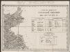
Umgebungen von Jägerndorf und die statistische Uebersicht
1 : 144000 K.K. Militärisches Geographisches Institut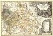
Principatvs Silesiae Karnoviensis nova et exactissima Tabula geographica, commonstrans insimul districtus ac Statvs Minores Frevdenthal Olbersdorf et Stevberndorf.
1 : 1125000 Mollova mapová sbírka Wieland, Johann Wolfgang Homann, Johann Baptista - dědici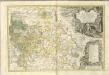
Principatvs Silesiae Karnoviensis nova et exactissima tabula geographica commonstrans insimul districtus ac statvs minores Frevdenthal, Olbersdorf et Stevberndorf
1 : 100000 Bruntál-oblast (Česko) Wieland, Johann Wolfgang Schubarth, Matthäus Homannianos Heredes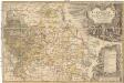
Principatvs Silesiae Karnoviensis nova et exactissima tabula geographica commonstrans insimul districtus ac statvs minores Frevdenthal Olbersdorf et Stevberndorf
1 : 100000 Bruntál-oblast (Česko) Wieland, Johann Wolfgang Schubarth, Matthäus ab Haeredibus Homannianis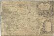
Principatvs Silesiae Karnoviensis nova et exactissima tabula geographica commonstrans insimul districtus ac Statvs minores Frevdenthal, Olbersdorf et Stevberndorf
1 : 100000 Bruntál-oblast (Česko) Wieland, Johann Wolfgang Schubarth, Matthäus Homannianos Heredes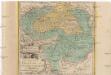
Die Fürstenthümer Troppau und Iaegerndorf in Ober-Schlesien
1 : 420000 Krnov-oblast (Česko) Schleuen, Johann David I.D. Schleuen
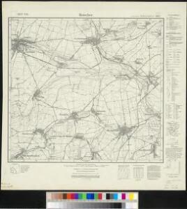
146. Ratibor, uit: Topographische Uebersichtskarte des Deutschen Reiches / herausgegeben v. d. Kartogr. Abt. d. Königl. Preuß. Landesaufnahme
1 : 200000 titelvariant: Topogr. Übersichtskarte des Deutschen Reiches; Annotatie: Titel boven bladen ook: Topogr. Übersichtskarte des Deutschen Reiches; Annotatie geografische gegevens: Op elk blad twee maatstokken: 10 Kilometer = 5,5 cm; 1 geogr. Meile = 3,6 cm; Legenda onder op elk blad Königlich Preußische Landesaufnahme. Kartographische Abtheilung [S.l : Königlich Preußische Landesaufnahme, Kartographische Abtheilung]
Theil von Schlesien.
Slezsko (Polsko) Weiland, Karl Ferdinand Bürck, A. im Verlage des Geograph. Instituts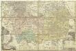
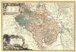
Principatus Silesiae Rattiboriensis
1 : 111000 Ratiboř-oblast (Polsko) Wieland, Johann Wolfgang Heredibus Homannianis
Marchionatus Moraviae Circulus Preroviensis.
1 : 233300 Mollova mapová sbírka Müller, Johann Christoph Homann, Johann Baptista

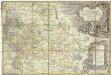
Marchionatus Moraviae circulus Preroviensis
1 : 150000 Morava (Česko) Müller, Johann Christoph Homann, Johann Baptist Io. Baptista Homanno
Marchionatus Moraviae circulus Preroviensis
1 : 150000 Morava (Česko) Müller, Johann Christoph Homann, Johann Baptist Io. Baptista Homanno
Marchionatus Moraviae circulus Preroviensis
1 : 150000 Morava (Česko) Müller, Johann Christoph Homann, Johann Baptist editore Io. Baptista Homanno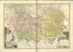

Nova et accurata geographica delineatio Ducatus Teschenensis...

Nova et accurata geographica delineatio Ducatus Teschenensis...

Sbírka map a diagramů použitých na mírových konferencích v Paříži v letech 1919 - 1920
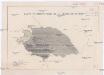
Carte ethnographique de la région de Ratiboř
Ratiboř (Polsko : oblast) Service cartographique de l'Armée Tchécoslovaque
[Die Markgraftschaft Mähren]
1 : 200000 Opava-oblast (Česko) Schenkl, Conrad Philipp Carl Winiker
Der Troppauer Kreis
1 : 200000 Jeseníky (Česko) Schenkl, Conrad Philipp Carl Winiker