Maps of Rothenbuch

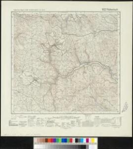
Meßtischblatt 6022 : Rothenbuch, 1941
1 : 250000 Rothenbuch. - Aufn. 1937, Ausg. 1939, bereinigt 1941. - 1:25000. - München, 1941. - 1 Kt.
152. Würzburg, uit: Topographische Uebersichtskarte des Deutschen Reiches / herausgegeben v. d. Kartogr. Abt. d. Königl. Preuß. Landesaufnahme
1 : 200000 titelvariant: Topogr. Übersichtskarte des Deutschen Reiches; Annotatie: Titel boven bladen ook: Topogr. Übersichtskarte des Deutschen Reiches; Annotatie geografische gegevens: Op elk blad twee maatstokken: 10 Kilometer = 5,5 cm; 1 geogr. Meile = 3,6 cm; Legenda onder op elk blad Königlich Preußische Landesaufnahme. Kartographische Abtheilung [S.l : Königlich Preußische Landesaufnahme, Kartographische Abtheilung]
Section Darmstadt, uit: Charte von dem Grossherzogtum Hessen und dem Herzogtum Nassau / trigonometrisch aufgenommen und hrsg. von C.L.P. Eckhardt
1 : 200000 titelvariant: Karte von Hessen und Nassau Eckhardt, C. L. P Darmstadt : Joh. Wilh. Heyer
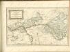
Delineatio Geographica generalis comprehendens VI. Foliis Singulos Principatvs Comitatvs Ditiones Dynastias omnes quotquot Imperio Serenissimi Principis Landgrafii Hasso-Darmstadiensis subsunt :
1 : 180000 Mollova mapová sbírka Bronner, Christian Maximilian Homann, Johann Baptista - dědici
COMITATVS | WERTHEIM | cum adjacentibus
[Amsterdam : Joan Blaeu]

ERPACH | COMITATVS
[Amsterdam : Joan Blaeu]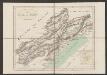
Erpach Comitatus. [Karte], in: Gerardi Mercatoris et I. Hondii Newer Atlas, oder, Grosses Weltbuch, Bd. 1, S. 227.
1 Karte aus Atlas Mercator, Gerhard und Hondius, Jodocus Jansson, Jan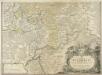
S. R. I. Principatvs Fvldensis in Bvchonia
1 : 210000 Mollova mapová sbírka Homann, Johann Baptist Homann, Johann Baptista
Comitatus Wertheimici Finitimarumque Regionum Nova Et Exacta Descriptio. [Karte], in: Gerardi Mercatoris et I. Hondii Newer Atlas, oder, Grosses Weltbuch, Bd. 1, S. 221.
1 Karte aus Atlas Mercator, Gerhard und Hondius, Jodocus Jansson, Jan
Comitatus Wertheimici Finitimarumque Regionum Nova Et Exacta Descriptio. [Karte], in: Novus atlas absolutissimus, Bd. 2, S. 180.
1 Karte aus Atlas Janssonius Offizin
Erpach Comitatus. [Karte], in: Novus atlas absolutissimus, Bd. 2, S. 192.
1 Karte aus Atlas Janssonius Offizin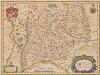
Erpach Comitatus. [Karte], in: Novus Atlas, das ist, Weltbeschreibung, Bd. 1, S. 270.
1 Karte aus Atlas Blaeu, Joan Blaeu, Willem Janszoon
Erpach Comitatus. [Karte], in: Le théâtre du monde, ou, Nouvel atlas contenant les chartes et descriptions de tous les païs de la terre, Bd. 1, S. 299.
1 Karte aus Atlas Blaeu, Willem Janszoon und Blaeu, Joan Blaeu, Willem Janszoon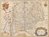
Erpach Comitatus. [Karte], in: Theatrum orbis terrarum, sive, Atlas novus, Bd. 1, S. 260.
1 Karte aus Atlas Blaeu, Joan Blaeu, Willem Janszoon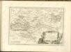

Partie Orientale du Temporel de l'Archevesché et Eslectorat de Mayence et le Comté de Reineck
1 : 250000 Mollova mapová sbírka Sanson, Guillaume Jaillot, Alexis Hubert
Der Lauf des Mains
1 : 370000 Aschaffenburg (Německo) Spruner, Karl von Verlag der Stahel'schen Buchhandlung
Kissingen 100, uit: [W. Liebenow's Special-Karte von Mittel-Europa]
1 : 300000 titelvariant: W. Liebenow's Mittel-Europa; Annotatie: Titel boven de bladen: W. Liebenow's Mittel-Europa Johannes Wilhelm Liebenow 1822-1897 Hannover : Hermann Oppermann
Das Franken-Weinland
1 : 493000 Bavorsko (Německo) Hellrung, Carl Ludwig Baensch, E. Rubach'schen Buchhandlung
Partie Orientale du Temporel de l'Archevesché et Eslectorat de Mayence et le Comté de Reineck
1 : 250000 Mollova mapová sbírka Sanson, Guillaume Covens, Johannes I
Pars Orientalis Temporalis Archiepiscopatvs et Electoratvs Mogvntinensis et Comitatus Reineck
1 : 260000 Mollova mapová sbírka Walther, Johann Georg Hailler, Martin Walther, Johann Georg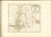
[...] Principatus & comitatus superioris Ysenburgensis, ac Hanoviensis, nova et accurata tabula, cum regionibus adjacentibus
Mohan (Německo) Buna, Wilhelm C. Brönner, Heinrich Ludwig Heinrich Ludwig Broenner
[Dolní Mohan a Porýní]
Mohan (Německo) Buna, Wilhelm C.
Reverendissimo Et Celsissimo S. R. I. Principi Constantino Sanctae Fuldensis Ecclesiae Abbati Augustissimae Romanorum Imperatricis Archi-Cancellario Per Germaniam Galliamque Primati Hanc Novam Veteris Buchoniae Tabulam Unacum Suis Confinys Dedicat Consecratque
1 : 340000 Mollova mapová sbírka Schannat, Johann Friedrich Puschner, Johann Georg
Buchaviae, sive Fuldensis Ditionis Typus. [Karte], in: Theatrum orbis terrarum, S. 236.
1 Karte aus Atlas Ortelius, Abraham Vrients, Jan Baptista
Partie Orientale Du Temporel De L'Archevesché et Eslectorat De Mayence et le Comté de Reineck [Karte], in: Atlas nouveau, contenant toutes les parties du monde [...], Bd. 1, S. 192.
1 Karte aus Atlas Sanson, Nicolas Jaillot, Alexis Hubert und Mortier, Pieter
Kissingen 100, uit: Special-Karte von Mittel-Europa / nach amtlichen Quellen bearbeitet von W. Liebenow
1 : 300000 titelvariant: W. Liebenow's Mittel-Europa; Annotatie: Titel boven de bladen: W. Liebenow's Mittel-Europa Johannes Wilhelm Liebenow 1822-1897 Frankfurt a. M. : Ludwig Ravenstein