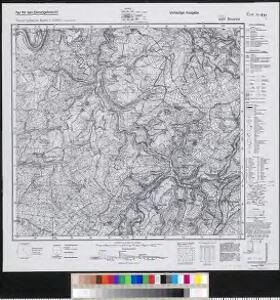
Maps of Beuren (Hochwald)

Meßtischblatt 6207 : Beuren, 1936
1 : 250000 Beuren. - Aufn. 1904, [hrsg. 1906], bericht. 1936. - 1:25000. - [Berlin]: Reichsamt für Landesaufnahme, 1936. - 1 Kt.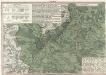
Ordre de Bataille
1 : 95000 Mollova mapová sbírka Homann, Johann Baptist Homann, Johann Baptista - dědici
Atlas zu der geognostischen Beschreibung des Landes, zwischen der untern Saar und dem Rheine
1 : 100000 Nordwest-Blatt Steininger, Johann Verlag der Lintz'schen Buchhandlung
[31] Sect. Trier, uit: Geologische Karte der Rheinprovinz und der Provinz Westphalen / ausgeführt durch H. von Dechen
1 : 80000 titelvariant: Dechen's geologische Karte vom Rheinland und Westphalen; Annotatie: Titel op bladoverzicht; Incompleet Heinrich von Dechen Berlin : Schropp
198 Birkenfeld, uit: Topographische Special-Karte von Deutschland (von Central-Europa) / begründet von D.G. Reymann ; [entworfen und gezeichn. von Heinrich Berghaus... [et al.]]
1 : 200000 Annotatie: Lit.: Daniel Gottlob Reymann und die "Topographische Special-Karte von Deutschland" / von Wolfgang Scharfe, in: Kartographische Nachrichten, 39 (1989), Heft I, p. 1-10; Handgeschreven titel: Reymann's Deutschland : 24 Sectionen: Jena, Penig, Dresden, Zittau, Hirschberg, Breslau, Brieg, Andernach, Coblenz, Giessen, Fulda, Schleusingen, Plauen, Zwickau, Teplitz, Jung Bunzlau, Hohenelbe, Glatz, Neisse, Simmern, Prag, Luxemburg, Birkenfeld; Aanwezig: 23 bladen Reymann, Daniel Gottlob; Berghaus, Heinrich [Berlin : 2. Departement des Kriegsministeriums, Bureau für Plan- und Kartenzeichnung]
149. Trier, uit: Topographische Uebersichtskarte des Deutschen Reiches / herausgegeben v. d. Kartogr. Abt. d. Königl. Preuß. Landesaufnahme
1 : 200000 titelvariant: Topogr. Übersichtskarte des Deutschen Reiches; Annotatie: Titel boven bladen ook: Topogr. Übersichtskarte des Deutschen Reiches; Annotatie geografische gegevens: Op elk blad twee maatstokken: 10 Kilometer = 5,5 cm; 1 geogr. Meile = 3,6 cm; Legenda onder op elk blad Königlich Preußische Landesaufnahme. Kartographische Abtheilung [S.l : Königlich Preußische Landesaufnahme, Kartographische Abtheilung]
Carte Particuliere de Pays qui sont situéz entre le Rhein, la Saare, la Moselle, et la Basse Alsace
1 : 150000 Mollova mapová sbírka Jaillot, Alexis-Hubert Jaillot, Alexis Hubert
Theatre de la Guerre dans les Pays qui sont situéz Entre le Rhin, la Saare, la Moselle et la Basse Alsace
1 : 150000 Mollova mapová sbírka Mortier, Pieter Mortier, Pierre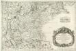
Treveri Archidiacones de Treves, et de Tholey dans le Dioecese de l'Archevesché de Treves.
Mollova mapová sbírka Sanson, Guillaume Sanson, Guillaume
Partie Occidentale Du Temporel De L'Archevesché et Eslectorat De Treves
1 : 210000 Mollova mapová sbírka Sanson, Guillaume Jaillot, Alexis Hubert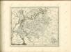

Partie Occidentale Du Temporel De L'Archevesché et Eslectorat, De Treves
1 : 210000 Mollova mapová sbírka Sanson, Guillaume Jaillot, Alexis Hubert
Theatre de la Guerre sus la Mosella, avec le choc., qui se donna entre les deux Armées le 20. Octobre 1735
Mollova mapová sbírka
Trier 112, uit: [W. Liebenow's Special-Karte von Mittel-Europa]
1 : 300000 titelvariant: W. Liebenow's Mittel-Europa; Annotatie: Titel boven de bladen: W. Liebenow's Mittel-Europa Johannes Wilhelm Liebenow 1822-1897 Hannover : Hermann Oppermann
Trier 112, uit: Special-Karte von Mittel-Europa / nach amtlichen Quellen bearbeitet von W. Liebenow
1 : 300000 titelvariant: W. Liebenow's Mittel-Europa; Annotatie: Titel boven de bladen: W. Liebenow's Mittel-Europa Johannes Wilhelm Liebenow 1822-1897 Frankfurt a. M. : Ludwig Ravenstein
Theatre De La Guerre Dans Les Pays Qui Sont Situéz Entre le Rhin, la Saare, la Moselle et la Basse Alsace. [Karte], in: Atlas nouveau, contenant toutes les parties du monde [...], Bd. 1, S. 235.
1 Karte aus Atlas Sanson, Nicolas Jaillot, Alexis Hubert und Mortier, Pieter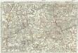
Tractus Hunnorum tabula exactissima, proponens maximam partem Sylvae olim dictae Arduenna, elect. Mogunt. Palat. ad Rhenum, et Trevir. princip. et com. Cattimelib. infer. Nassov. cum adjac. comit. et regionibus intra Rhenum, Mosellam, Saramque, secundum exactissimae vederoviae
Ardeny Buna, Wilhelm C.
[Poříčí Mosely]
Mosela, řeka-oblast Buna, Wilhelm C.
Partie Occidentale Du Temporel De L'Archevesché et Eslectorat, De Treves. [Karte], in: Atlas nouveau, contenant toutes les parties du monde [...], Bd. 1, S. 196.
1 Karte aus Atlas Sanson, Nicolas Jaillot, Alexis Hubert und Mortier, Pieter
Le Theatre de Bellone :
Mollova mapová sbírka Schenk, Pieter Braakman, Adriaan
Carte topographique d'Allemagne
1 : 224000 Falc Rýnská Jaeger, Johann Wilhelm Abraham I. W. A. Iaeger
Partie Orientale du Palatinat et Eslectorat du Rhein.
1 : 260000 Mollova mapová sbírka Sanson, Guillaume Jaillot, Alexis Hubert
[Kaart], uit: Kleines Relief-Panorama des Rheines
titelvariant: Kleines farbiges Relief-Panorama des Rheines; Annotatie: Titel op omslag: Kleines farbiges Relief-Panorama des Rheines; Met ill. van bezienswaardigheden aan weerszijden van de kaart Köln am Rhein : Hoursch & Bechstedt
Le Duché de Luxembourg divisé en Quartier Walon et Allemand
1 : 140000 Mollova mapová sbírka Jaillot, Alexis-Hubert Jaillot, Alexis Hubert

Höhenschichten-Karte der Eifel / von H. Rauff ; gezeichn. von W. Rose
1 : 200000 Annotatie geografische gegevens: Gebaseerd op: Topografische Uebersichtskarte des Deutschen Reiches Hermann Rauff; W. Rose fl. 1900 Bonn : Cohen
Archiepiscopatus et Electoratus Trevirensis Novissima delineatio
1 : 310000 Mollova mapová sbírka Wit, Frederik de Wit, Frederick

Partie Occidentale Du Palatinat et Eslectorat Du Rhein Le Duché De Simmeren, Les Comtés De Spanheim, et De Veldentz a la Maison Palatine. [...] [Karte], in: Atlas nouveau, contenant toutes les parties du monde [...], Bd. 1, S. 180.
1 Karte aus Atlas Sanson, Nicolas Jaillot, Alexis Hubert und Mortier, Pieter