Maps of Hallerndorf

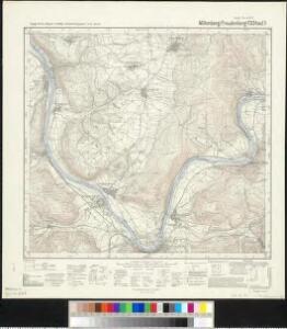
Meßtischblatt 130 : Miltenberg (Freudenberg), 1935
1 : 250000 Miltenberg (Freudenberg). - Aufn. 1935, Ausg. 1935. - 1:25000. - München, 1935. - 1 Kt.
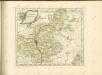
153. Bamberg, uit: Topographische Uebersichtskarte des Deutschen Reiches / herausgegeben v. d. Kartogr. Abt. d. Königl. Preuß. Landesaufnahme
1 : 200000 titelvariant: Topogr. Übersichtskarte des Deutschen Reiches; Annotatie: Titel boven bladen ook: Topogr. Übersichtskarte des Deutschen Reiches; Annotatie geografische gegevens: Op elk blad twee maatstokken: 10 Kilometer = 5,5 cm; 1 geogr. Meile = 3,6 cm; Legenda onder op elk blad Königlich Preußische Landesaufnahme. Kartographische Abtheilung [S.l : Königlich Preußische Landesaufnahme, Kartographische Abtheilung]
Tabulae Geographicae Principatus Brandenburg: Culmb: sive Baruthini Pars Inferior cum adjacentibus Regionibus exhibita et Sculpta
1 : 150000 Mollova mapová sbírka Seutter, Matthäus Seutter, Matthäus
Das Nürenbergische Gebiet
1 : 200000 Mollova mapová sbírka Scheurer, Christoph Seutter, Matthäus
Das Nürenbergische Gebiet
1 : 200000 Mollova mapová sbírka Scheurer, Christoph Seutter, Matthäus
Das Nürenbergische Gebiet mit allen Nürnbergischen Hauptmannschafften
1 : 200000 Norimberk-oblast (Německo) Scheurer, Christoph
Nürnberg 115, uit: Special-Karte von Mittel-Europa / nach amtlichen Quellen bearbeitet von W. Liebenow
1 : 300000 titelvariant: W. Liebenow's Mittel-Europa; Annotatie: Titel boven de bladen: W. Liebenow's Mittel-Europa Johannes Wilhelm Liebenow 1822-1897 Frankfurt a. M. : Ludwig Ravenstein
Tabulae geographicae principatus Brandenburg. Culmb. sive Baruthini
1 : 179600 Bavorsko severní (Německo) Lotter, Tobias Conrad Tob. Conrad Lotter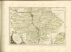
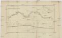
Plan und Laengenprofil des Kanals zur Verbindung des Rheins mit der Donau
1 : 375000 Bavorsko (Německo) Barraga
Deutsche Strassenprofilkarte für Rad - und Autofahrer 58 Nürnberg

Carte topographique d'Allemagne contenant la Franconie sçavoir une partie des evechés de Wurzbourg de Bamberg
1 Karte : Kupferdruck ; 46 x 62 cm Jaeger; Facius se vend chés l'auteur
Tabula Geographica Nova exhibens Partem Infra Montanam Burggraviatus Norimbergensis Sive Principatum Onolsbacensem cum Terris Limitaneis Accurate delineatam
1 : 140000 Mollova mapová sbírka Vetter, Johann Georg Windter, Johann W. Vetter, Johann Georg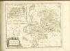

Sac. Rom. Imperii Principatus & Episcopatus Bambergensis Nova Tabula Geographica
1 : 260000 Mollova mapová sbírka Homann, Johann Baptist Homann, Johann Baptista
Geographica provinciarum Sueviae descriptio, 2
4 Blätter : Johann Georg Bodenehr
Tabula Geographica Nova exhibens Partem Infra Montanam Burggraviatus Norimbergensis Sive Principatum Onolsbacensem cum Terris Limitaneis Accurate delineatam
1 : 140000 Mollova mapová sbírka Vetter, Johann Georg Kauffer, Michael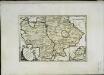
Des Bisthums Bamberg südliche Aemter
1 Karte : Kupferdruck ; 20 x 30 cm Reilly F. J. J. von Reilly
Sacri Romani imperii circuli et electoratus Bavariae tabula, 1
4 Blätter : s.n.
Militair Karte von Süd-Deutschland in 20 Sectionen
1 : 400000 6. Section Coulon, Alois von A. von Coulon
Sac. Rom. Imperii principatus & episcopatus Bambergensis nova tabula geographica
1 : 215000 Bamberg-oblast (Německo) Homann, Johann Baptist á Io. Bapt. Homanno
Sac. Rom. Imperii principatus [et] episcopatus Bambergensis nova tabula geographica
1 Karte : Kupferdruck ; 47 x 56 cm Homann Johann Baptist Homann
Sac. Rom. Imperii principatus [et] episcopatus Bambergensis nova tabula geographica
1 Karte : Kupferdruck ; 47 x 56 cm Homann Johann Baptist Homann
Tabula Geographica Novissima Principalis Episcopatûs Bambergensis
1 : 260000 Mollova mapová sbírka Seutter, Matthäus Seutter, Matthäus
Nova et accuratior repraesentatio geographica Sacr. Rom. Imperii episcopatus Würceburgensis Franciae orientalis ducatus cum omnibus suis praefecturis, et ditionibus eo pertinentibus etc
1 : 380000 Württembersko (Německo) Lotter, Tobias Conrad impensis Tobiae Conradi Lotteri
Nova et accuratior repraesentatio geographica Sacr. Rom. Imperii episcopatus Würceburgensis Franciae orientalis ducatus cum omnibus suis praefecturis, et ditionibus eo pertinentibus etc
1 : 380000 Württembersko (Německo) Lotter, Tobias Conrad impensis Tobiae Conradi Lotteri
Nova et Accuratior Repraesentatio Geographica Sacr. Rom. Imperii Episcopatus Würceburgensis Franciae Orientalis Ducatus cum Omnibus suis Praefecturis, et ditionibus eò Pertinentibus etc.
1 : 360000 Mollova mapová sbírka Seutter, Matthäus Seutter, Matthäus
Special=Charte der kön. baier. Provinz Bamberg
1 Karte auf 4 Blatt : Kupferdruck ; 73 x 72 cm Roppelt in der kön. baier. priv. Landkartenhandlung Ad: Gottl: Schneider u: Weigels