Maps of Rimbach

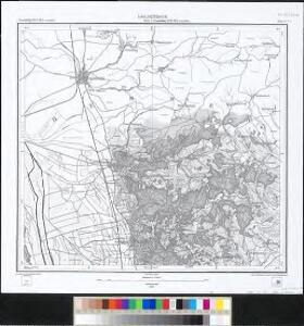
Meßtischblatt 6+5 : Laudenbach, 1882
1 : 250000 Laudenbach. - [Hrsg.] 1882. - 1:25000. - Leipzig: Giesecke & Devrient, 1882. - 1 Kt.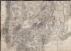
Brouillon Einer Gegend vom Odenwald
Lyncker, Ludwig
Le Flambeau de la Guerre Allumee au Rhin
Mollova mapová sbírka Delisle, Guillaume Schenk, Peter II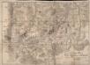
Brouillon Einer Gegend vom Odenwald
Weiss
Topographisch-Militairische Carte
Bechstatt, I. C.

Erpach Comitatus
1 : 170000 Mollova mapová sbírka Keere, Pieter van den Schenk, Peter I
Erpach Comitatus
1 : 170000 Mollova mapová sbírka Keere, Pieter van den Janssonius, Johannes I
151. Darmstadt, uit: Topographische Uebersichtskarte des Deutschen Reiches / herausgegeben v. d. Kartogr. Abt. d. Königl. Preuß. Landesaufnahme
1 : 200000 titelvariant: Topogr. Übersichtskarte des Deutschen Reiches; Annotatie: Titel boven bladen ook: Topogr. Übersichtskarte des Deutschen Reiches; Annotatie geografische gegevens: Op elk blad twee maatstokken: 10 Kilometer = 5,5 cm; 1 geogr. Meile = 3,6 cm; Legenda onder op elk blad Königlich Preußische Landesaufnahme. Kartographische Abtheilung [S.l : Königlich Preußische Landesaufnahme, Kartographische Abtheilung]
Section Erbach, uit: Charte von dem Grossherzogtum Hessen und dem Herzogtum Nassau / trigonometrisch aufgenommen und hrsg. von C.L.P. Eckhardt
1 : 200000 titelvariant: Karte von Hessen und Nassau Eckhardt, C. L. P Darmstadt : Joh. Wilh. Heyer

ERPACH | COMITATVS
[Amsterdam : Joan Blaeu]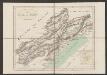
Erpach Comitatus. [Karte], in: Gerardi Mercatoris et I. Hondii Newer Atlas, oder, Grosses Weltbuch, Bd. 1, S. 227.
1 Karte aus Atlas Mercator, Gerhard und Hondius, Jodocus Jansson, Jan
Erpach Comitatus. [Karte], in: Novus atlas absolutissimus, Bd. 2, S. 192.
1 Karte aus Atlas Janssonius Offizin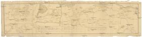
Camps et marches de l'armée imperiale com[m]andée par S.A.S. le prince de Savoye pour retourner de Wesenthal prés de Philippsbourg, et aller passer le Rhein a Mayence, l'armée de France étant campé a Oppenheim prés de céte ville
Mannheim (Německo) Müller, Johann Conrad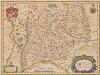
Erpach Comitatus. [Karte], in: Novus Atlas, das ist, Weltbeschreibung, Bd. 1, S. 270.
1 Karte aus Atlas Blaeu, Joan Blaeu, Willem Janszoon
Erpach Comitatus. [Karte], in: Le théâtre du monde, ou, Nouvel atlas contenant les chartes et descriptions de tous les païs de la terre, Bd. 1, S. 299.
1 Karte aus Atlas Blaeu, Willem Janszoon und Blaeu, Joan Blaeu, Willem Janszoon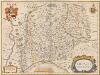
Erpach Comitatus. [Karte], in: Theatrum orbis terrarum, sive, Atlas novus, Bd. 1, S. 260.
1 Karte aus Atlas Blaeu, Joan Blaeu, Willem Janszoon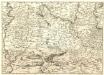
S.R.Imp. Circuli Franconici Geographica Delineatio Francken-Land mit Seinen Gräntzen
Mollova mapová sbírka Endter, Wolfgang Moritz Endter, Wolfgang Moritz
Mannheim 113, uit: [W. Liebenow's Special-Karte von Mittel-Europa]
1 : 300000 titelvariant: W. Liebenow's Mittel-Europa; Annotatie: Titel boven de bladen: W. Liebenow's Mittel-Europa Johannes Wilhelm Liebenow 1822-1897 Hannover : Hermann Oppermann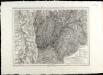
SpecialKarte von dem Odenwald, dem Bauland und einem Theil des Spessart's
1 : 216000 Haas, Johann Heinrich; Meister, G.; Felsing, Conrad
Geognostische Karte von dem Odenwald und einigen angraenzenden Gegenden
1 : 235000 Odenwald, pohoří (Německo) Klipstein, A. MK

Mannheim 113, uit: Special-Karte von Mittel-Europa / nach amtlichen Quellen bearbeitet von W. Liebenow
1 : 300000 titelvariant: W. Liebenow's Mittel-Europa; Annotatie: Titel boven de bladen: W. Liebenow's Mittel-Europa Johannes Wilhelm Liebenow 1822-1897 Frankfurt a. M. : Ludwig Ravenstein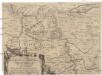
Eigentliche Entwerffung deßn Marquis Spinolae Lägern bey Maintz und Oppenheim
Mohuč (Německo)
Geognostische Reise-Karte der Umgegend von Heidelberg
1 : 250000 Groos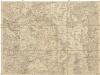
Kriegs Theater der teutschen und franzoesischen Graenz Landen zwischen dem Rhein und der Mosel, im Jahr 1794
1 : 90000 Mosel (Německo) Dewarat, Peter Leizel, Balthasar Friedrich I.L.C. Rheinwald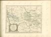

Provinz Starkenburg und Rheinhessen
1 : 250000 Hügel, Adolf Diehl