Maps of Lambsheim-Heßheim

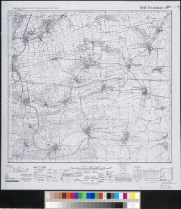
Meßtischblatt 6415 : Grünstadt-Ost (Pfalz), 1938
1 : 250000 Grünstadt-Ost (Pfalz). - Aufn. 1913, Ausg. 1921, Erkund. 1937, bericht. 1938. - 1:25000. - [München]: Bayer. Landesvermessungsamt, 1938. - 1 Kt.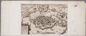
Abriss der Stadt Franckenthal, wie solche von dem Vice General Don Gonçalo Fernandes de Cordova belägert gewesen 1621
Annotatie: Oorspr. verschenen in: Österreichischer Lorbeerkranz oder Kayserl. Victorii ... / Nicolaus Bellus. - Frankfurt am Main : Schönwetter, 1625 [S.l. : s.n.]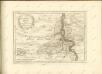
Geographica Provinciarum Sveviae Descriptio =
Mollova mapová sbírka Hurter, Johann Christoph Bodenehr, Gabriel
Le Flambeau de la Guerre Allumee au Rhin
Mollova mapová sbírka Delisle, Guillaume Schenk, Peter II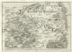
Geographica Provinciarum Sveviae Descriptio =
Mollova mapová sbírka Hurter, Johann Christoph Bodenehr, Johann Georg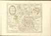

150. Mainz, uit: Topographische Uebersichtskarte des Deutschen Reiches / herausgegeben v. d. Kartogr. Abt. d. Königl. Preuß. Landesaufnahme
1 : 200000 titelvariant: Topogr. Übersichtskarte des Deutschen Reiches; Annotatie: Titel boven bladen ook: Topogr. Übersichtskarte des Deutschen Reiches; Annotatie geografische gegevens: Op elk blad twee maatstokken: 10 Kilometer = 5,5 cm; 1 geogr. Meile = 3,6 cm; Legenda onder op elk blad Königlich Preußische Landesaufnahme. Kartographische Abtheilung [S.l : Königlich Preußische Landesaufnahme, Kartographische Abtheilung]
Territorium Seculare Episcopatus Wormatiensis Tabula Geographica
1 : 130000 Mollova mapová sbírka Homann, Johann Baptist Homann, Johann Baptista - dědici
Karte eines Theils des ehemaligen Departement des Donnersberges nach Cantons eingetheilt
1 : 178300 Mohuč (Německo : oblast) Veil
Section Worms, uit: Charte von dem Grossherzogtum Hessen und dem Herzogtum Nassau / trigonometrisch aufgenommen und hrsg. von C.L.P. Eckhardt
1 : 200000 titelvariant: Karte von Hessen und Nassau Eckhardt, C. L. P Darmstadt : Joh. Wilh. Heyer
Partie du Cours du Palatinat du Rhin Levesché de Spire et de Worms les Comté de Spanheim et de Linange levée Sur les lieu
1 : 160000 Mollova mapová sbírka Baillieul, Gaspard Bailleul, Gaspard
Carte Particuliere de Pays qui sont situéz entre le Rhein, la Saare, la Moselle, et la Basse Alsace
1 : 150000 Mollova mapová sbírka Jaillot, Alexis-Hubert Jaillot, Alexis Hubert
Exact und Gantz accurater Plan
1 : 570000 Mollova mapová sbírka Geyer, Friedrich W. Berndt, Johann Christoph Geyer, Friedrich
Le Cours du Rhein, depuis Spire jusqu'a Mayence
1 : 180000 Mollova mapová sbírka Fer, Nicolas de Fer, Nicolas de
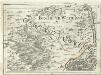
Special Carte des Rheinlaufes von Speier bis Bingen nebst den angraentzenden Gegenden von beiden Ufern bis an die Gebirge
1 : 250000 Bingen (Německo) Dewarat, Peter Verhelst, Aegid Schwan und Götz
Carte Particuliere des Pays qui sont situéz entre le Rhein, la Saare, la Moselle, et la Basse Alsace
1 : 150000 Mollova mapová sbírka Mortier, Pieter Mortier, Pierre
Mannheim 113, uit: [W. Liebenow's Special-Karte von Mittel-Europa]
1 : 300000 titelvariant: W. Liebenow's Mittel-Europa; Annotatie: Titel boven de bladen: W. Liebenow's Mittel-Europa Johannes Wilhelm Liebenow 1822-1897 Hannover : Hermann Oppermann
Geognostische Karte von dem Odenwald und einigen angraenzenden Gegenden
1 : 235000 Odenwald, pohoří (Německo) Klipstein, A. MK

Mannheim 113, uit: Special-Karte von Mittel-Europa / nach amtlichen Quellen bearbeitet von W. Liebenow
1 : 300000 titelvariant: W. Liebenow's Mittel-Europa; Annotatie: Titel boven de bladen: W. Liebenow's Mittel-Europa Johannes Wilhelm Liebenow 1822-1897 Frankfurt a. M. : Ludwig Ravenstein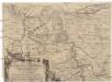
Eigentliche Entwerffung deßn Marquis Spinolae Lägern bey Maintz und Oppenheim
Mohuč (Německo)
Geognostische Reise-Karte der Umgegend von Heidelberg
1 : 250000 Groos
Partie Occidentale du Palatinat et Eslectorat du Rhein
1 : 125000 Mollova mapová sbírka Sanson, Guillaume Jaillot, Alexis Hubert
Carte Particuliere Des Pays Qui Sont Situéz Entre Le Rhein, La Saare, la Moselle, Et La Basse Alsace [...] [Karte], in: Atlas nouveau, contenant toutes les parties du monde [...], Bd. 1, S. 244.
1 Karte aus Atlas Sanson, Nicolas Jaillot, Alexis Hubert und Mortier, Pieter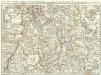
Novissima Statuum Imperii Intra Rhenum & Tuberum Repraesentatio
1 : 210000 Mollova mapová sbírka Buna, Wilhelm C. Reinhardt, Andreas Broenner, Heinrich Ludwig
Partie Orientale du Palatinat et Eslectorat du Rhein.
1 : 260000 Mollova mapová sbírka Sanson, Guillaume Jaillot, Alexis Hubert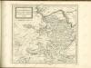

Provinz Starkenburg und Rheinhessen
1 : 250000 Hügel, Adolf Diehl