Maps of Frankenthal (Pfalz)

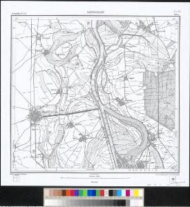
Meßtischblatt 12 : Sandhofen, 1910
1 : 250000 Sandhofen. - 2. Aufl., ergänzt bis incl. 1897, einz. Nachtr. 1910. - 1:25000. - Karlsruhe: Kunstdr. Künstlerbund, 1910. - 1 Kt.
Meßtischblatt 12 : Sandhofen, 1884
1 : 250000 Sandhofen. - [Ausg.] 1882 u. 1884. - 1:25000. - Leipzig: Giesecke & Devrient, 1884. - 1 Kt.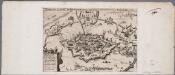
Abriss der Stadt Franckenthal, wie solche von dem Vice General Don Gonçalo Fernandes de Cordova belägert gewesen 1621
Annotatie: Oorspr. verschenen in: Österreichischer Lorbeerkranz oder Kayserl. Victorii ... / Nicolaus Bellus. - Frankfurt am Main : Schönwetter, 1625 [S.l. : s.n.]
Manheimium
Mollova mapová sbírka Seutter, Matthäus Seutter, Matthäus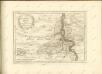
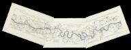
[Lauf des Rheins von Neuburg bis unterhalb Mannheim im Anfange des Jahres 1837] : Tab. 1: Hydrographische Charte vom Lauf des Rheins v. Neuburg bis Sondernheim die im Jahre 1817 angefangen Rectification desselben enthaltend. 2: Hydrographische Carte vom Lauf des Rheins von Sondernheim bis Otterstatt mit Rücksicht auf die Rectification desselben . 3: Hydrographische Carte vom Lauf des Rheins mit Rücksicht auf die Rectification desselben : Distrikte v. Waldsee bis an die Hessischen Grenze
1 : 80000 [S.l.] : Grosh. Bad. Landw. Wochenblatt
Manheimium munitißimus oppidum et hodierno die residentia electoris palatini, ad confluentes Rheni et Nicri, juxta recentißimam delineationem
Mannheim (Německo) Seutter, Matthäus per Matthaeum Seutter
Mannheim

Manheimium
Mannheim (Německo) Seutter, Matthäus Adrichem, Christiaan van per Matthaeum Seutter
Manheimium
Mannheim (Německo) Seutter, Matthäus Furlanetto, Lodovico per Matthaeum Seutter
Hodierna Sedes Electoris Palatini Manheimium
1 : 8000 Mollova mapová sbírka Homann, Johann Baptist Homann, Johann Baptista - dědici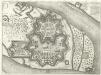
Mannheim
Mollova mapová sbírka Merian, Matthaeus Merian, Matthäus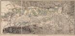
[Topographische Charte der Gegend zwischen Rhein, Neckar und Mayn]
Meister, G.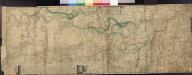
Le Cours Du Rhin Depuis Spire juisqu'à Mayence, les marches et Contremarches de l'Armée Francoise et les Camps y sont marqués Come aussi de l'Armée Alliée du coté du Main l'ann 1743 avec la Situation de l'Odewwald et du Berg Straass
Denis, Ferdinand
Territorium Seculare Episcopatus Wormatiensis Tabula Geographica
1 : 130000 Mollova mapová sbírka Homann, Johann Baptist Homann, Johann Baptista - dědici
Karte eines Theils des ehemaligen Departement des Donnersberges nach Cantons eingetheilt
1 : 178300 Mohuč (Německo : oblast) Veil
151. Darmstadt, uit: Topographische Uebersichtskarte des Deutschen Reiches / herausgegeben v. d. Kartogr. Abt. d. Königl. Preuß. Landesaufnahme
1 : 200000 titelvariant: Topogr. Übersichtskarte des Deutschen Reiches; Annotatie: Titel boven bladen ook: Topogr. Übersichtskarte des Deutschen Reiches; Annotatie geografische gegevens: Op elk blad twee maatstokken: 10 Kilometer = 5,5 cm; 1 geogr. Meile = 3,6 cm; Legenda onder op elk blad Königlich Preußische Landesaufnahme. Kartographische Abtheilung [S.l : Königlich Preußische Landesaufnahme, Kartographische Abtheilung]
Section Worms, uit: Charte von dem Grossherzogtum Hessen und dem Herzogtum Nassau / trigonometrisch aufgenommen und hrsg. von C.L.P. Eckhardt
1 : 200000 titelvariant: Karte von Hessen und Nassau Eckhardt, C. L. P Darmstadt : Joh. Wilh. Heyer
Partie du Cours du Palatinat du Rhin Levesché de Spire et de Worms les Comté de Spanheim et de Linange levée Sur les lieu
1 : 160000 Mollova mapová sbírka Baillieul, Gaspard Bailleul, Gaspard
Exact und Gantz accurater Plan
1 : 570000 Mollova mapová sbírka Geyer, Friedrich W. Berndt, Johann Christoph Geyer, Friedrich
Le Cours du Rhein, depuis Spire jusqu'a Mayence
1 : 180000 Mollova mapová sbírka Fer, Nicolas de Fer, Nicolas de
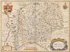
ERPACH | COMITATVS
[Amsterdam : Joan Blaeu]
Special Carte des Rheinlaufes von Speier bis Bingen nebst den angraentzenden Gegenden von beiden Ufern bis an die Gebirge
1 : 250000 Bingen (Německo) Dewarat, Peter Verhelst, Aegid Schwan und Götz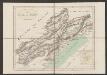
Erpach Comitatus. [Karte], in: Gerardi Mercatoris et I. Hondii Newer Atlas, oder, Grosses Weltbuch, Bd. 1, S. 227.
1 Karte aus Atlas Mercator, Gerhard und Hondius, Jodocus Jansson, Jan
Carte Particuliere des Pays qui sont situéz entre le Rhein, la Saare, la Moselle, et la Basse Alsace
1 : 150000 Mollova mapová sbírka Mortier, Pieter Mortier, Pierre
Erpach Comitatus. [Karte], in: Novus atlas absolutissimus, Bd. 2, S. 192.
1 Karte aus Atlas Janssonius Offizin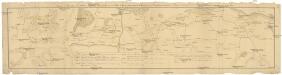
Camps et marches de l'armée imperiale com[m]andée par S.A.S. le prince de Savoye pour retourner de Wesenthal prés de Philippsbourg, et aller passer le Rhein a Mayence, l'armée de France étant campé a Oppenheim prés de céte ville
Mannheim (Německo) Müller, Johann Conrad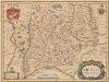
Erpach Comitatus. [Karte], in: Novus Atlas, das ist, Weltbeschreibung, Bd. 1, S. 270.
1 Karte aus Atlas Blaeu, Joan Blaeu, Willem Janszoon
Erpach Comitatus. [Karte], in: Le théâtre du monde, ou, Nouvel atlas contenant les chartes et descriptions de tous les païs de la terre, Bd. 1, S. 299.
1 Karte aus Atlas Blaeu, Willem Janszoon und Blaeu, Joan Blaeu, Willem Janszoon