Maps of Schönthal

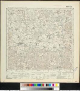
Meßtischblatt 6641 : Rötz, 1940
1 : 250000 Rötz. - Aufn. 1929,30, Ausg. 1932, einz. Nachtr. 1940, bereinigt 1940. - 1:25000. - München: Bayer. Topographischen Bureau, Hauptvermessungsabt. XIII, 1940. - 1 Kt.

Klentsch
1 : 75000 Klenčí pod Čerchovem (Česko : oblast) K. u. k. Militärgeographisches Institut
Kleneč p. Čerchovem
1 : 75000 Klenčí pod Čerchovem-oblast (Česko) Vojenský zeměpisný ústav
III. vojenské mapování 4249
1 : 75000
II. vojenské mapování 23
1 : 144000
Klentsch.
from Spezialkarte der osterreichisch-ungarischen Monarchie.
Umgebungen von Klentsch
1 : 750000 Klenčí pod Čerchovem (Česko : oblast) Kiss, Josef K. k. militär-geographisches Institut
[Kartenblatt]
1 : 25000 Bystřice (Česko : zaniklá obec) Reichsamt für Landesaufnahme
[Kartenblatt]
1 : 25000 Klenčí pod Čerchovem (Česko : oblast) Reichsamt für Landesaufnahme
Bairische Landtafeln XXIIII. Darinnē das hochlöblich Furstenthumb Obern unnd Nidern Bayrn sambt der Obern Pflaz Erz unnd Stifft Salzburg Eichstet unnd andern mehrern anstossenden Herschafftē]
1 : 145000 Mollova mapová sbírka Apian, Philipp Amman, Jost Apian, Petrus
165. Cham, uit: Topographische Uebersichtskarte des Deutschen Reiches / herausgegeben v. d. Kartogr. Abt. d. Königl. Preuß. Landesaufnahme
1 : 200000 titelvariant: Topogr. Übersichtskarte des Deutschen Reiches; Annotatie: Titel boven bladen ook: Topogr. Übersichtskarte des Deutschen Reiches; Annotatie geografische gegevens: Op elk blad twee maatstokken: 10 Kilometer = 5,5 cm; 1 geogr. Meile = 3,6 cm; Legenda onder op elk blad Königlich Preußische Landesaufnahme. Kartographische Abtheilung [S.l : Königlich Preußische Landesaufnahme, Kartographische Abtheilung]
Müllerova mapa Čech
1 : 132000
exhibet Continuationem Partis Palatinatus Super: Regiminis Straubing: et Villam Jmperialem Augusta Tiberii
1 : 150000 Mollova mapová sbírka Buna, Wilhelm C. Broenner, Heinrich Ludwig
Pars II. exhibet continuationem partis palatinatus super: regiminis Straubing: et villam jmperialem Augusta Tiberii
1 Karte : 54 x 52 cm Heinrich Ludwig Broenner
Fischerei-Karte des Radbusa-Gebietes
Radbuza-oblast (Česko) Schubert, Ottokar Deutsche agrarische Druckerei
Nová mapa království Českého
Mappa geographica regni Bohemiae in duodecim circulos divisae ...

Charte vom Klattauer Kreise ...

Charte vom Klattauer Kreise des Königreiches Böheim
1 : 260000 Klatovy-oblast (Česko) Kreibich, František Jakub Jindřich Pluth, Fr. C. W. Enders
Charte vom Klattauer Kreise des Königreiches Böheim
1 : 260000 Klatovy-oblast (Česko) Kreibich, František Jakub Jindřich Pluth, Fr. C. W. Enders
Charte vom Klattauer Kreise des Königreiches Böheim
1 : 246000 Klatovy-oblast (Česko) Kreibich, František Jakub Jindřich Enders, C. W. C.W. Enders
Charte vom Klattauer Kreise des Königreiches Böheim
1 : 246000 Klatovy-oblast (Česko) Kreibich, František Jakub Jindřich Enders, C. W. C.W. Enders
Charte vom Klattauer Kreise des Königreiches Böheim
1 : 246000 Klatovy-oblast (Česko) Kreibich, František Jakub Jindřich Enders, C. W. C.W. Enders
Charte vom Klattauer Kreise des Königreiches Böheim
1 : 246000 Klatovy-oblast (Česko) Kreibich, František Jakub Jindřich Enders, C. W. C.W. Enders
Charte vom Klattauer Kreise des Königreiches Böheim
1 : 246000 Klatovy-oblast (Česko) Kreibich, František Jakub Jindřich Enders, C. W. C.W. Enders
Charte vom Klattauer Kreise des Königreiches Böheim
1 : 246000 Klatovy-oblast (Česko) Kreibich, František Jakub Jindřich Enders, C. W. C.W. Enders
Charte vom Klattauer Kreise des Königreiches Böheim
1 : 246000 Klatovy-oblast (Česko) Kreibich, František Jakub Jindřich Enders, C. W. C.W. Enders
Charte vom Königgrätzer Kreise des Königreiches Böheim
1 : 241000 Hradec Králové-oblast (Česko) Kreibich, František Jakub Jindřich Enders, C. W. C.W. Enders
Charte vom Königgrätzer Kreise des Königreiches Böheim
1 : 260000 Hradec Králové-oblast (Česko) Kreibich, František Jakub Jindřich C. W. Enders
Charte vom Königgrätzer Kreise des Königreiches Böheim
1 : 260000 Hradec Králové-oblast (Česko) Kreibich, František Jakub Jindřich Enders, C. W. C.W. Enders
Charte vom Königgrätzer Kreise des Königreiches Böheim
1 : 260000 Hradec Králové-oblast (Česko) Kreibich, František Jakub Jindřich Enders, C. W. C.W. Enders
Charte vom Königgrätzer Kreise des Königreiches Böheim
1 : 241000 Hradec Králové-oblast (Česko) Kreibich, František Jakub Jindřich Enders, C. W. C.W. Enders
Charte vom Königgrätzer Kreise des Königreiches Böheim
1 : 241000 Hradec Králové-oblast (Česko) Kreibich, František Jakub Jindřich Enders, C. W. C.W. Enders
Charte vom Königgrätzer Kreise des Königreiches Böheim
1 : 241000 Hradec Králové-oblast (Česko) Kreibich, František Jakub Jindřich Enders, C. W. C.W. Enders
Charte vom Königgrätzer Kreise des Königreiches Böheim
1 : 241000 Hradec Králové-oblast (Česko) Kreibich, František Jakub Jindřich Enders, C. W. C.W. Enders
Charte vom Königgrätzer Kreise des Königreiches Böheim
1 : 241000 Hradec Králové-oblast (Česko) Kreibich, František Jakub Jindřich Enders, C. W. C.W. Enders
Charte vom Königgrätzer Kreise des Königreiches Böheim
1 : 260000 Hradec Králové-oblast (Česko) Kreibich, František Jakub Jindřich Kolowrat-Liebsteinský, František Antonín C. W. Enders
Charte vom Königgrätzer Kreise des Königreiches Böheim
1 : 241000 Hradec Králové-oblast (Česko) Kreibich, František Jakub Jindřich Enders, C. W. C.W. Enders
Charte vom Königgrätzer Kreise des Königreiches Böheim
1 : 241000 Hradec Králové-oblast (Česko) Kreibich, František Jakub Jindřich Enders, C. W. C.W. Enders