Maps of Lustadt

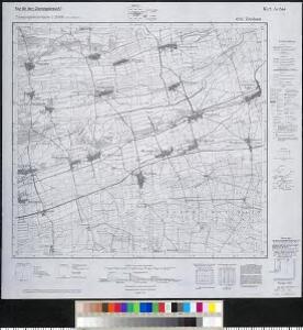
Meßtischblatt 6715 : Zeiskam, 1943
1 : 250000 Zeiskam. - Aufn. 1898, 1902, 1909, hrsg. 1912, bericht. 193. - 1:25000. - Wiesbaden: Hauptvermessungsabteilung XI, 1943. - 1 Kt.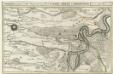
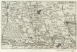
Die Gegend zwischen Landau, Speyer u. Philipsburg
1 : 100000 Mollova mapová sbírka Bodenehr, Gabriel Bodenehr, Gabriel
Les environs de Landau
1 Karte : Kupferdruck ; 23 x 33 cm Fer; Inselin Nicolas de Fer
[Philipsbourg]
1 Blatt : 60 x 91 cm s.n.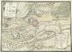
Carte des Environs de Landav avec le Camp et l'Attaque De L'Arméé Imperiale qui forme sou Siege en MDCCII
Mollova mapová sbírka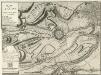
Plann von Landau
Mollova mapová sbírka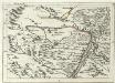
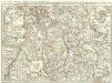
Geographica Provinciarum Sveviae Descriptio =
Mollova mapová sbírka Hurter, Johann Christoph Bodenehr, Gabriel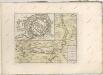
Landau mitt umbliegenden dörfferen und Stätten
1 : 170000 Mollova mapová sbírka Person, Nikolaus Person, Nicolas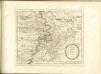
Accurate Special-Charte der Gegend des Rheins, von Ettlingen, Carls Ruhe, Philippsburg, Bruchsal, bis Mannheim, etc. Entworffen
Riecke, Gustav Friedrich; Ostertag, Heinrich Jonas; Cöntgen, Bartolomäus Anton Brönner
160. Landau, uit: Topographische Uebersichtskarte des Deutschen Reiches / herausgegeben v. d. Kartogr. Abt. d. Königl. Preuß. Landesaufnahme
1 : 200000 titelvariant: Topogr. Übersichtskarte des Deutschen Reiches; Annotatie: Titel boven bladen ook: Topogr. Übersichtskarte des Deutschen Reiches; Annotatie geografische gegevens: Op elk blad twee maatstokken: 10 Kilometer = 5,5 cm; 1 geogr. Meile = 3,6 cm; Legenda onder op elk blad Königlich Preußische Landesaufnahme. Kartographische Abtheilung [S.l : Königlich Preußische Landesaufnahme, Kartographische Abtheilung]
Carte Particuliere de Pays qui sont situéz entre le Rhein, la Saare, la Moselle, et la Basse Alsace
1 : 150000 Mollova mapová sbírka Jaillot, Alexis-Hubert Jaillot, Alexis Hubert
Exact und Gantz accurater Plan
1 : 570000 Mollova mapová sbírka Geyer, Friedrich W. Berndt, Johann Christoph Geyer, Friedrich
Suevia Universa
1 : 170000 Mollova mapová sbírka Michal, Jacques de Seutter, Matthäus Seutter, Matthäus
Partie du Cours du Rhein, ou se Trouvent les Villes de Spire Philipsbourg Landau Hagenau et le Fort Louis, Dessigne et Levee sur les Lieues
1 : 160000 Mollova mapová sbírka Baillieul, Gaspard Bailleul, Gaspard
Carlsruhe - Stuttgart
1 : 200000 Herder, Benjamin
Carte Particuliere des Pays qui sont situéz entre le Rhein, la Saare, la Moselle, et la Basse Alsace
1 : 150000 Mollova mapová sbírka Mortier, Pieter Mortier, Pierre
Territorium Seculare Episcopatvs Spirensis una cum terris adiacentibus
1 : 140000 Mollova mapová sbírka Blödtner, Cyriak Homann, Johann Baptista - dědici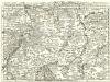
Staaten ahm Rhein, und Necker
1 : 180000 Mollova mapová sbírka Person, Nikolaus Person, Nicolas
Specialkarte Der Gegenden Zwischen Dem Rhein Und Der Saar
1 : 170000 Rheinwald, Johann Ludwig Christian; Dewarat, Peter; Walbert
Mannheim 113, uit: [W. Liebenow's Special-Karte von Mittel-Europa]
1 : 300000 titelvariant: W. Liebenow's Mittel-Europa; Annotatie: Titel boven de bladen: W. Liebenow's Mittel-Europa Johannes Wilhelm Liebenow 1822-1897 Hannover : Hermann Oppermann

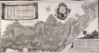
Suevia universa IX. tabulis delineata, 1
1 Blatt : s.n.
Mannheim 113, uit: Special-Karte von Mittel-Europa / nach amtlichen Quellen bearbeitet von W. Liebenow
1 : 300000 titelvariant: W. Liebenow's Mittel-Europa; Annotatie: Titel boven de bladen: W. Liebenow's Mittel-Europa Johannes Wilhelm Liebenow 1822-1897 Frankfurt a. M. : Ludwig Ravenstein
Geognostische Reise-Karte der Umgegend von Heidelberg
1 : 250000 Groos
Carte Particuliere Des Pays Qui Sont Situéz Entre Le Rhein, La Saare, la Moselle, Et La Basse Alsace [...] [Karte], in: Atlas nouveau, contenant toutes les parties du monde [...], Bd. 1, S. 244.
1 Karte aus Atlas Sanson, Nicolas Jaillot, Alexis Hubert und Mortier, Pieter
Partie du Haut Rhein, où se trouvent la Haute et Basse Alsace, Suntgow, Brisgow, Ortenaw, et partie des marquisats de Baden, 1
1 Blatt : 51 x 39 cm de Fer
Des Herzogthums Würtemberg nordwestliche Aemter mit der freyen Reichsstadt Weil
1 Karte : Kupferdruck ; 23 x 26 cm Reilly F. J. J. von Reilly