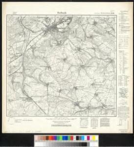
Maps of Théding

Meßtischblatt 3556 : Forbach, 1936
1 : 250000 Forbach. - Hrsg. 1883, bericht. 1929, einzelne Nachtr. 1936. - 1:25000. - Berlin: Reichsamt für Landesaufnahme, 1936. - 1 Kt.
Le Flambeau de la Guerre Allumee au Rhin
Mollova mapová sbírka Delisle, Guillaume Schenk, Peter II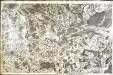
[Metz]
1 Blatt : 60 x 91 cm s.n.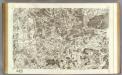
141 Metz.
1 : 86400 Cassini family; Cassini, Cesar-Francois, 1714-1784
Le Flambeau de la Guerre Allumee au Rhin
Mollova mapová sbírka Delisle, Guillaume Schenk, Peter II
Obszar zagłębia Saary
Deutschland Frankreich Saargebiet Grenze Wierzbicki, B.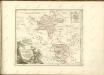

Sbírka map a diagramů použitých na mírových konferencích v Paříži v letech 1919 - 1920

Die Grenzen des Saargebietes nach dem Wortlaut des Friedensvertrages vom 25. 6. 1919
1 : 100000
Carte Particuliere de Pays qui sont situéz entre le Rhein, la Saare, la Moselle, et la Basse Alsace
1 : 150000 Mollova mapová sbírka Jaillot, Alexis-Hubert Jaillot, Alexis Hubert
Partie Meridionale Des Pays Qui Sont Situéz Entre Le Rhein, La Saare, La Moselle Et La Basse Alsace
1 : 150000 Mollova mapová sbírka Mortier, Pieter Covens, Johannes I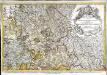
Le pays Messin, partie du temporel de l'evesché de Metz et partie du balliage allemand, dans le duché de Lorraine
1 Karte : Kupferdruck ; 44 x 68 cm Jaillot Alexis-Hubert Jaillot
Lotharingia Septentrionalis Loraine vers le Seption.
1 : 330000 Mollova mapová sbírka Valk, Gerhard Schenk, Peter I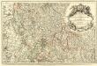
Les Estats du Duc de Lorraine ou sont les Duchez de Lorraine et de Bar :
1 : 180000 Mollova mapová sbírka Jaillot, Alexis-Hubert Jaillot, Alexis Hubert
Trier 112, uit: [W. Liebenow's Special-Karte von Mittel-Europa]
1 : 300000 titelvariant: W. Liebenow's Mittel-Europa; Annotatie: Titel boven de bladen: W. Liebenow's Mittel-Europa Johannes Wilhelm Liebenow 1822-1897 Hannover : Hermann Oppermann
Mediomatrici
1 Karte : Kupferdruck ; 43 x 50 cm Sanson chez l'auteur
Partie Meridionale Des Pays Qui Sont Situéz Entre Le Rhein, La Saare, La Moselle, Et La Basse Alsace. [Karte], in: Atlas nouveau, contenant toutes les parties du monde [...], Bd. 1, S. 241.
1 Karte aus Atlas Sanson, Nicolas Jaillot, Alexis Hubert und Mortier, Pieter
Archid.conné de Sarbovrg dans l'Evesché de Metz
1 : 240000 Mollova mapová sbírka Sanson, Nicolas Mariette, Pierre Sanson, Nicolas
Mediomatrici
1 Karte : Kupferdruck ; 41 x 48 cm Sanson; Mariette chez P. Mariette
Trier 112, uit: Special-Karte von Mittel-Europa / nach amtlichen Quellen bearbeitet von W. Liebenow
1 : 300000 titelvariant: W. Liebenow's Mittel-Europa; Annotatie: Titel boven de bladen: W. Liebenow's Mittel-Europa Johannes Wilhelm Liebenow 1822-1897 Frankfurt a. M. : Ludwig Ravenstein
Mediomatrici
1 Karte : Kupferdruck ; 41 x 48 cm Sanson; Robert de Vaugondy ches le Sr. Robert geog. du roi quai de l'horloge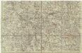
[Lotrinsko a Sársko]
Lotrinsko (Francie) Buna, Wilhelm C.
Le Theatre de Bellone :
Mollova mapová sbírka Schenk, Pieter Braakman, Adriaan
Carte topographique d'Allemagne
1 : 224000 Falc Rýnská Jaeger, Johann Wilhelm Abraham I. W. A. Iaeger
Mediomatrici
1 Karte : Kupferdruck ; 44 x 51 cm Sanson; Robert de Vaugondy chez l'auteur, chés le Sr. Robert geog. ord. du roi quai de l'horloge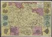
Carte du Duché de Lorraine, gravée sur les derniers memoires
1 : 600000 [Amsterdam] : [De La Feuille?]
Département de la Meurte
1 Karte : Kupferdruck ; 48 x 48 cm Houdan au bureau de l'atlas national rue de la Harpe no. 26, et au dépôt du dit atlas rue de la Monnoye no. 5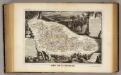
Dept. De La Moselle.
1 : 455000 Levasseur, Victor.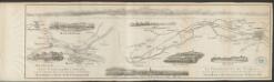
Alsatia inferior [Karte], in: Gerardi Mercatoris Atlas, sive, Cosmographicae meditationes de fabrica mundi et fabricati figura, S. 365.
1 Karte aus Atlas Mercator, Gerhard Montanus, Petrus