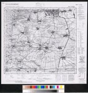
Maps of Billigheim-Ingenheim

Meßtischblatt 6814 : Landau, 1944
1 : 250000 Landau. - Aufn. 1912, hrsg. 1916, bericht. 1938, letzte Na. - 1:25000. - Wiesbaden: Hauptvermessungsabteilung XI, 1944. - 1 Kt.
Die Accurateste Fürstellung, der Belägerungs Arbeit vor Landau wie solche im Sept. 1704 zu infestirn angefangen und den 25. Nov. zu unsterblicher Glorie ihrer May. des Röm. Königs erobert worden
Landau in der Pfalz (Německo) Marchand, Johann Christian Ioh. Christian Marchand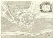
Plan der Situation und Fortification von Landau
1 : 5000 Mollova mapová sbírka Du Chaffat, Antoine Bourgoin, P.
Landau :
1 : 15000 Mollova mapová sbírka Bodenehr, Gabriel Bodenehr, Gabriel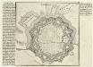
Landau.
1 : 15000 Mollova mapová sbírka Bodenehr, Gabriel Bodenehr, Gabriel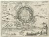
Die Belagerung Landau in Ao. 1702.
1 : 15000 Mollova mapová sbírka Bodenehr, Gabriel Bodenehr, Gabriel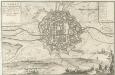
Landau
Mollova mapová sbírka Nolin, Jean-Baptiste Bourgoin, P. Nolin, Jean Baptiste II.
Landau]
Mollova mapová sbírka
Landau
Mollova mapová sbírka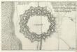
Landaw :
Mollova mapová sbírka Person, Nikolaus Person, Nicolas
Landaw
Mollova mapová sbírka Person, Nikolaus Person, Nicolas
Landau, Ville dans la Basse Alsace sur le Rhin
Mollova mapová sbírka Seutter, Matthäus Seutter, Matthäus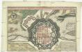
Landau, ville dans la Basse Alsace sur le Rhin, celebre des diverses siéges, et presentement tres fortificée du roy de France
Landau in der Pfalz (Německo) Seutter, Matthäus M. Seutter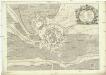
Plan der Situation und Fortification von Landau
Landau in der Pfalz (Německo) Du Chaffat, Antoine Hondt, Pierre de par du Chaffat
Plan de Landau avec tous ses nouveaux ouvrages
1 : 4000 Landau in der Pfalz (Německo) Inselin, Charles chez C. Inselin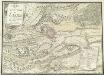
Carte des Environs de Landav avec le Camp et l'Attaque De L'Arméé Imperiale qui forme sou Siege en MDCCII
Mollova mapová sbírka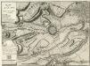
Plann von Landau
Mollova mapová sbírka
Landau, op de nieuweste wyse gesterkt door de Fransse, in Neder-Elsas, aan het rieviertie de Queiche in den Rhyn vallende by Germesheim
Landau in der Pfalz (Německo) Schenk, Pieter P. Schenk
Les environs de Landau
1 Karte : Kupferdruck ; 23 x 33 cm Fer; Inselin Nicolas de Fer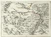
Geographica Provinciarum Sveviae Descriptio =
Mollova mapová sbírka Hurter, Johann Christoph Bodenehr, Gabriel
Le cours du Rhin de Bâle à Hert près Philisbourg contenant l'Alsace et partie du Brisgau, 5
1 Blatt : 77 x 52 cm Le Rouge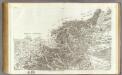
161 Landau, Wissembourg.
1 : 86400 Cassini family; Cassini, Cesar-Francois, 1714-1784
Le Flambeau de la Guerre Allumee au Rhin
Mollova mapová sbírka Delisle, Guillaume Schenk, Peter II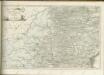
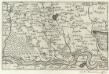
Landau mitt umbliegenden dörfferen und Stätten
1 : 170000 Mollova mapová sbírka Person, Nikolaus Person, Nicolas
160. Landau, uit: Topographische Uebersichtskarte des Deutschen Reiches / herausgegeben v. d. Kartogr. Abt. d. Königl. Preuß. Landesaufnahme
1 : 200000 titelvariant: Topogr. Übersichtskarte des Deutschen Reiches; Annotatie: Titel boven bladen ook: Topogr. Übersichtskarte des Deutschen Reiches; Annotatie geografische gegevens: Op elk blad twee maatstokken: 10 Kilometer = 5,5 cm; 1 geogr. Meile = 3,6 cm; Legenda onder op elk blad Königlich Preußische Landesaufnahme. Kartographische Abtheilung [S.l : Königlich Preußische Landesaufnahme, Kartographische Abtheilung]
[Landau - Wissembourg]
1 Blatt : 60 x 90 cm Brunet s.n.
Alasatia superior et inferior III. tabulis delineata, 3
1 Blatt : 62 x 59 cm s.n.
Carte Particuliere de Pays qui sont situéz entre le Rhein, la Saare, la Moselle, et la Basse Alsace
1 : 150000 Mollova mapová sbírka Jaillot, Alexis-Hubert Jaillot, Alexis Hubert