Maps of Kraichtal

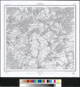
Meßtischblatt 47 : Odenheim, 1876
1 : 250000 Odenheim. - 1:25000. - Leipzig: Giesecke & Devrient, 1876. - 1 Kt.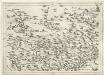
Geographica Provinciarum Sveviae Descriptio :
Mollova mapová sbírka Hurter, Johann Christoph Küsel, Melchior Bodenehr, Johann Georg
Vorstellung des Campements der kayserl. u. Reichs-Armee zu Bruchsal
1 Karte auf 2 Blättern : Kupferdruck ; je 23 x 44 cm Riecke Homännische Erben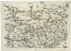
Geographica Provinciarum Sveviae Descriptio =
Mollova mapová sbírka Hurter, Johann Christoph Bodenehr, Gabriel
Le Flambeau de la Guerre Allumee au Rhin
Mollova mapová sbírka Delisle, Guillaume Schenk, Peter II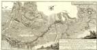
Carte von Linie und Innondation, von Bruchsal bis Kethsch, woselbst die Innondation in Rhein fließet.
1 : 65000 Mollova mapová sbírka Riecke, Gustav Friedrich Bodenehr, Gabriel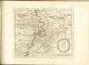

Der Pfinz und Enz Kreis im Grossherzogthum Baden
1 : 200000 Bádensko (Německo) Krauth Wolff, F. C.F. Müllerschen Buchhandlung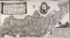
Accurate Special-Charte der Gegend des Rheins, von Ettlingen, Carls Ruhe, Philippsburg, Bruchsal, bis Mannheim, etc. Entworffen
Riecke, Gustav Friedrich; Ostertag, Heinrich Jonas; Cöntgen, Bartolomäus Anton Brönner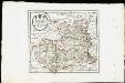
Des Herzogthums Würtemberg nordwestliche Aemter mit der freyen Reichsstadt Weil : Nro. 187
Reilly, Franz Johann Joseph von
Suevia Universa
1 : 170000 Mollova mapová sbírka Michal, Jacques de Seutter, Matthäus Seutter, Matthäus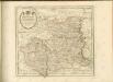

Carlsruhe - Stuttgart
1 : 200000 Herder, Benjamin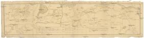
Camps et marches de l'armée imperiale com[m]andée par S.A.S. le prince de Savoye pour retourner de Wesenthal prés de Philippsbourg, et aller passer le Rhein a Mayence, l'armée de France étant campé a Oppenheim prés de céte ville
Mannheim (Německo) Müller, Johann Conrad
Territorium Seculare Episcopatvs Spirensis una cum terris adiacentibus
1 : 140000 Mollova mapová sbírka Blödtner, Cyriak Homann, Johann Baptista - dědici
Die untere Markgrafschaft Baaden oder die Grafschaft Eberstein mit den Durlachischen Landen
1 Karte : Kupferdruck ; 18 x 24 cm Reilly F. J. J. von Reilly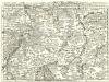
Staaten ahm Rhein, und Necker
1 : 180000 Mollova mapová sbírka Person, Nikolaus Person, Nicolas
Kriegs-Theatrum.
Mollova mapová sbírka Lidl, Johann Jakob Lidl, Johann Jacob

Suevia universa IX. tabulis delineata, 1
1 Blatt : s.n.
Geognostische Reise-Karte der Umgegend von Heidelberg
1 : 250000 Groos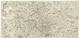
S.R.Imp. Circuli Franconici Geographica Delineatio Francken-Land mit Seinen Gräntzen
Mollova mapová sbírka Endter, Wolfgang Moritz Endter, Wolfgang Moritz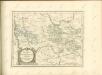

Des Herzogthums Würtemberg nordwestliche Aemter mit der freyen Reichsstadt Weil
1 Karte : Kupferdruck ; 23 x 26 cm Reilly F. J. J. von Reilly
Le Theatre de la Guerre Sur le Haut Rhein
1 : 142000 Mollova mapová sbírka Sanson, Guillaume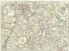
Novissima Statuum Imperii Intra Rhenum & Tuberum Repraesentatio
1 : 210000 Mollova mapová sbírka Buna, Wilhelm C. Reinhardt, Andreas Broenner, Heinrich Ludwig
Partie Orientale du Palatinat et Eslectorat du Rhein. Les Eveschés de Spire, de Wormes et le Comté de Linange
1 : 260000 Mollova mapová sbírka Sanson, Guillaume Jaillot, Alexis Hubert
Nova et accuratißima Ducatus Wurtenbergici
1 : 300000 Mollova mapová sbírka Seutter, Matthäus Seutter, Matthäus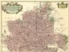
Carte tres Particuliere du Duché de Wirtemberg
1 : 240000 Mollova mapová sbírka Fer, Nicolas de Loon, Herman van L'Isle, Guillaume de