Maps of Mécleuves

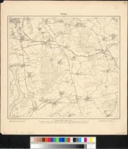
Meßtischblatt 6903 : Verny, 1882
1 : 250000 Verny. - Aufn. 1880. - 1:25000. - [Berlin]: Reichsamt für Landesaufnahme, 1882. - 1 Kt.
Meßtischblatt 6903 : Verny, 1876
1 : 250000 Verny. - Aufn. 1857. - 1:25000. - [Berlin]: Reichsamt für Landesaufnahme, 1876. - 1 Kt.
Schlacht bei Colombey-Nouilly
1 : 25000 Mety (Francie)
Die Kriegsoperationen um Metz im Jahr 1870
1 : 50000 Algermissen, Johann Ludwig [s.n.]

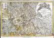
Territorivm Metense
1 : 160000 Mollova mapová sbírka Fabert, Abraham Schenk, Peter I
TERRITORIVM | METENSE
Auctore | AB. FABERT | Consule urbis | Metensis | LE PAIS | MESSIN Amsterdami | Apud Guiljelmum et | Johannem Blaeuw
Messin Nova Territorii Metensis Descriptio [Karte], in: Gerardi Mercatoris et I. Hondii Newer Atlas, oder, Grosses Weltbuch, Bd. 2, S. 44.
1 Karte aus Atlas Mercator, Gerhard und Hondius, Jodocus Jansson, Jan
Territorium Metense
1 : 67000
Territorivm Metense
1 Karte : Kupferdruck ; 36 x 47 cm Fabert; Schenk; Valck apud G. Valk et P. Schenk
Territorivm Metense
1 Karte : Kupferdruck ; 37 x 48 cm Fabert; Blaeu; Blaeu apud Guiljelmum et Johannem Blaeuw
Nova territorii Metensis descriptio
1 Karte : Kupferdruck ; 35 x 45 cm Fabert; Hondius; Hondius excusum apud Iodocum et Henricum Hondium fratres
Territorium Metense [...] Le Pais Messin. [Karte], in: Novus atlas absolutissimus, Bd. 4, S. 88.
1 Karte aus Atlas Janssonius Offizin
Territorium Metense [...] Le Pais Messin. [Karte], in: Novus Atlas, das ist, Weltbeschreibung, Bd. 2, S. 71.
1 Karte aus Atlas Blaeu, Joan Blaeu, Willem Janszoon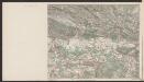
Territorium Metense [...] Le Pais Messin. [Karte], in: Le théâtre du monde, ou, Nouvel atlas contenant les chartes et descriptions de tous les païs de la terre, Bd. 2, S. 69.
1 Karte aus Atlas Blaeu, Willem Janszoon und Blaeu, Joan Blaeu, Willem Janszoon
[Metz]
1 Blatt : 60 x 91 cm s.n.
141 Metz.
1 : 86400 Cassini family; Cassini, Cesar-Francois, 1714-1784
158. Metz, uit: Topographische Uebersichtskarte des Deutschen Reiches / herausgegeben v. d. Kartogr. Abt. d. Königl. Preuß. Landesaufnahme
1 : 200000 titelvariant: Topogr. Übersichtskarte des Deutschen Reiches; Annotatie: Titel boven bladen ook: Topogr. Übersichtskarte des Deutschen Reiches; Annotatie geografische gegevens: Op elk blad twee maatstokken: 10 Kilometer = 5,5 cm; 1 geogr. Meile = 3,6 cm; Legenda onder op elk blad Königlich Preußische Landesaufnahme. Kartographische Abtheilung [S.l : Königlich Preußische Landesaufnahme, Kartographische Abtheilung]
Umgegend von Metz
Le pays Messin, partie du temporel de l'evesché de Metz et partie du balliage allemand, dans le duché de Lorraine
1 Karte : Kupferdruck ; 44 x 68 cm Jaillot Alexis-Hubert Jaillot
Lotharingia Septentrionalis Loraine vers le Seption.
1 : 330000 Mollova mapová sbírka Valk, Gerhard Schenk, Peter I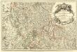
Les Estats du Duc de Lorraine ou sont les Duchez de Lorraine et de Bar :
1 : 180000 Mollova mapová sbírka Jaillot, Alexis-Hubert Jaillot, Alexis Hubert
Mediomatrici
1 Karte : Kupferdruck ; 43 x 50 cm Sanson chez l'auteur
Nancy 126, uit: [W. Liebenow's Special-Karte von Mittel-Europa]
1 : 300000 titelvariant: W. Liebenow's Mittel-Europa; Annotatie: Titel boven de bladen: W. Liebenow's Mittel-Europa Johannes Wilhelm Liebenow 1822-1897 Hannover : Hermann Oppermann
Archid.conné de Sarbovrg dans l'Evesché de Metz
1 : 240000 Mollova mapová sbírka Sanson, Nicolas Mariette, Pierre Sanson, Nicolas
Mediomatrici
1 Karte : Kupferdruck ; 41 x 48 cm Sanson; Mariette chez P. Mariette
Nancy 126, uit: Special-Karte von Mittel-Europa / nach amtlichen Quellen bearbeitet von W. Liebenow
1 : 300000 titelvariant: W. Liebenow's Mittel-Europa; Annotatie: Titel boven de bladen: W. Liebenow's Mittel-Europa Johannes Wilhelm Liebenow 1822-1897 Frankfurt a. M. : Ludwig Ravenstein
Mediomatrici
1 Karte : Kupferdruck ; 41 x 48 cm Sanson; Robert de Vaugondy ches le Sr. Robert geog. du roi quai de l'horloge
Nova & Accurata delineatio geographica | EPISCOPATUS METENSIS | Quo ad Iurisdictionem temporalem
[Amsterdam : Joan Blaeu]