Maps of Walzbachtal

Maps of Walzbachtal

$title$

Meßtischblatt 52 : Weingarten, 1876

1 : 250000 Weingarten. - 1:25000. - Leipzig: Giesecke & Devrient, 1876. - 1 Kt.
$title$

173 Philipsbourg.

1 : 86400 Cassini family; Cassini, Cesar-Francois, 1714-1784
$title$

Vorstellung des Campements der kayserl. u. Reichs-Armee zu Bruchsal

1 Karte auf 2 Blättern : Kupferdruck ; je 23 x 44 cm Riecke Homännische Erben
$title$

Geographica Provinciarum Sveviae Descriptio =

Mollova mapová sbírka Hurter, Johann Christoph Bodenehr, Gabriel
$title$

Carte von der Innondation von Ettlingen biss zu dem Kislauer Schlosse

1 Karte auf 2 Blatt : Kupferdruck ; 23 x 94 cm Riecke; Bodenehr
$title$

[Philipsbourg]

1 Blatt : 60 x 91 cm s.n.
$title$

Carte von der Innondation Von Ettlingen biss zu dem Kislauer Schlosse

1 : 35000 Mollova mapová sbírka Riecke, Gustav Friedrich Bodenehr, Gabriel
$title$

Vorstellung des Campements der Kayserl. u. Reichs-Armee zu Bruchsal mit denen Inondationen u. neuen Linien 1735 in denen Gegenden von Ettlingen bis Langenbruck

1 : 45000 Mollova mapová sbírka Riecke, Gustav Friedrich Homann, Johann Baptista - dědici
$title$

Vorstellung des Campements der Kayserl. u. Reichs-Armee zu Bruchsal mit denen Inondationen u. neuen Linien 1735 in denen Gegenden von Ettlingen bis Langenbruck

1 : 45000 Mollova mapová sbírka Riecke, Gustav Friedrich Homann, Johann Baptista - dědici
$title$

Carte von Linie und Innondation, von Bruchsal bis Kethsch, woselbst die Innondation in Rhein fließet.

1 : 65000 Mollova mapová sbírka Riecke, Gustav Friedrich Bodenehr, Gabriel
$title$

Le Flambeau de la Guerre Allumee au Rhin

Mollova mapová sbírka Delisle, Guillaume Schenk, Peter II
$title$

$title$

Der Pfinz und Enz Kreis im Grossherzogthum Baden

1 : 200000 Bádensko (Německo) Krauth Wolff, F. C.F. Müllerschen Buchhandlung
$title$

Accurate Special-Charte der Gegend des Rheins, von Ettlingen, Carls Ruhe, Philippsburg, Bruchsal, bis Mannheim, etc. Entworffen

Riecke, Gustav Friedrich; Ostertag, Heinrich Jonas; Cöntgen, Bartolomäus Anton Brönner
$title$

Des Herzogthums Würtemberg nordwestliche Aemter mit der freyen Reichsstadt Weil : Nro. 187

Reilly, Franz Johann Joseph von
$title$

Carte Particuliere de Pays qui sont situéz entre le Rhein, la Saare, la Moselle, et la Basse Alsace

1 : 150000 Mollova mapová sbírka Jaillot, Alexis-Hubert Jaillot, Alexis Hubert
$title$

Exact und Gantz accurater Plan

1 : 570000 Mollova mapová sbírka Geyer, Friedrich W. Berndt, Johann Christoph Geyer, Friedrich
$title$

$title$

Suevia Universa

1 : 170000 Mollova mapová sbírka Michal, Jacques de Seutter, Matthäus Seutter, Matthäus
$title$

$title$

Carlsruhe - Stuttgart

1 : 200000 Herder, Benjamin
$title$

Camps et marches de l'armée imperiale com[m]andée par S.A.S. le prince de Savoye pour retourner de Wesenthal prés de Philippsbourg, et aller passer le Rhein a Mayence, l'armée de France étant campé a Oppenheim prés de céte ville

Mannheim (Německo) Müller, Johann Conrad
$title$

Territorium Seculare Episcopatvs Spirensis una cum terris adiacentibus

1 : 140000 Mollova mapová sbírka Blödtner, Cyriak Homann, Johann Baptista - dědici
$title$

Die untere Markgrafschaft Baaden oder die Grafschaft Eberstein mit den Durlachischen Landen

1 Karte : Kupferdruck ; 18 x 24 cm Reilly F. J. J. von Reilly
$title$

Staaten ahm Rhein, und Necker

1 : 180000 Mollova mapová sbírka Person, Nikolaus Person, Nicolas
$title$

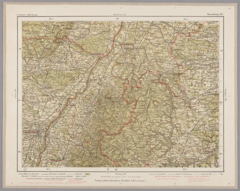
Strassburg 127, uit: Special-Karte von Mittel-Europa / nach amtlichen Quellen bearbeitet von W. Liebenow

1 : 300000 titelvariant: W. Liebenow's Mittel-Europa; Annotatie: Titel boven de bladen: W. Liebenow's Mittel-Europa Johannes Wilhelm Liebenow 1822-1897 Frankfurt a. M. : Ludwig Ravenstein
$title$

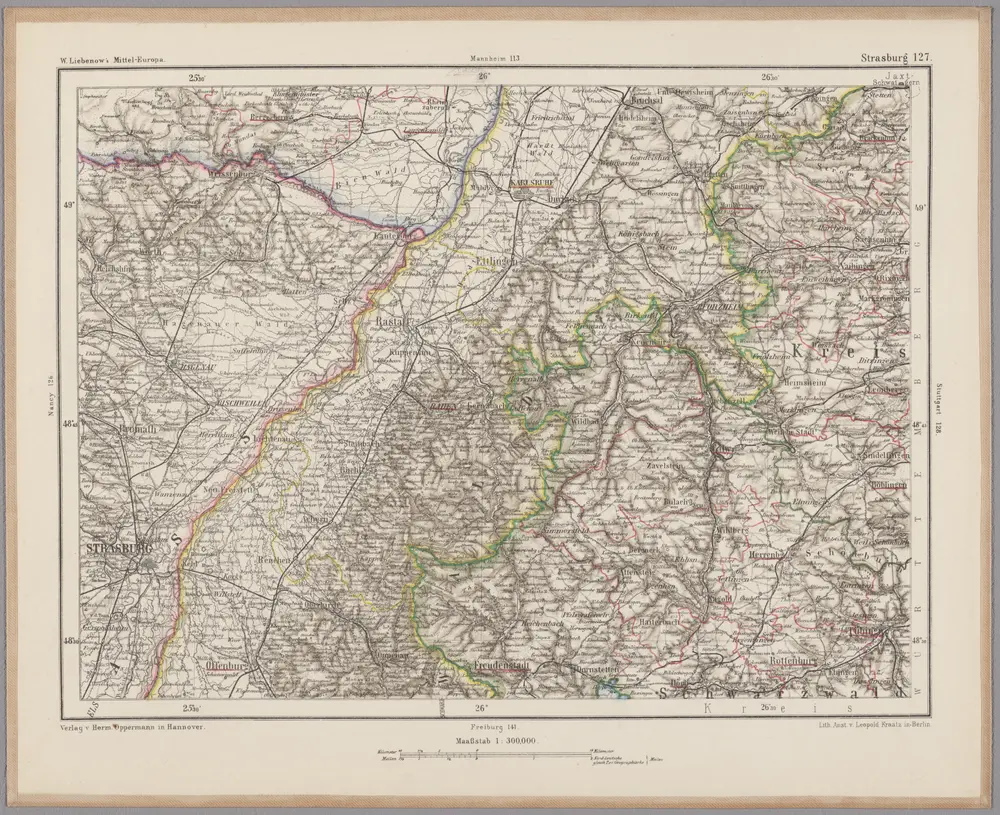
Strasburg 127, uit: [W. Liebenow's Special-Karte von Mittel-Europa]

1 : 300000 titelvariant: W. Liebenow's Mittel-Europa; Annotatie: Titel boven de bladen: W. Liebenow's Mittel-Europa Johannes Wilhelm Liebenow 1822-1897 Hannover : Hermann Oppermann
$title$

Kriegs-Theatrum.

Mollova mapová sbírka Lidl, Johann Jakob Lidl, Johann Jacob
$title$

$title$

Suevia universa IX. tabulis delineata, 1

1 Blatt : s.n.
© MapTiler © OpenStreetMap contributors
How does it work?
These instructions will show you how to find historical maps online.
Getting started
Type the place name in the search box to find the exact location. You can further adjust the search by zooming in and out.
Zoom
Zoom in and out with the buttons or use your mouse or touchpad natively.
Exact Area tool
Click here and draw a rectangle over the map to precisely define the search area.
Set filters
Narrow your search with advanced settings, such as Years (from/to), Fulltext, Publisher, etc.
Results
See the results of your search on the right side. You can scroll down to find more maps of this location.
?

Download OldMapsOnline Mobile